Bridge Data Fields
Bridge data can be edited on either the Bridge Grid Window of the Links Grid or the Bridge Property Sheet.
To view and edit all bridge data, use the Property Sheet.
This table describes all the bridge specific data which can be used to define a bridge.
 Common Data Fields
 Fields that are common to the majority of objects can be found in the Common Fields topic.
Bridge Data
Database Table Name: hw_bridge
|
Show Columns |
Database Names |
|
Size, Type and Units |
|
|
Defaults and Error Limits |
|
Field Name |
Help Text |
Database Field |
Size |
Precision |
Default |
Error Lower Limit |
Error Upper Limit |
Warning Lower Limit |
Warning Upper Limit |
||||||||||||||||||||||||||||||||||||||||||||||||||||||||||||||||||||||||||||||||||||||||||||||||||||||
|---|---|---|---|---|---|---|---|---|---|---|---|---|---|---|---|---|---|---|---|---|---|---|---|---|---|---|---|---|---|---|---|---|---|---|---|---|---|---|---|---|---|---|---|---|---|---|---|---|---|---|---|---|---|---|---|---|---|---|---|---|---|---|---|---|---|---|---|---|---|---|---|---|---|---|---|---|---|---|---|---|---|---|---|---|---|---|---|---|---|---|---|---|---|---|---|---|---|---|---|---|---|---|---|---|---|---|---|---|---|---|---|
| US node ID | Type in a node reference or choose an existing node reference from the drop down list. This makes up the first part of the link reference. | us_node_id | Text | 64 | 0 | ||||||||||||||||||||||||||||||||||||||||||||||||||||||||||||||||||||||||||||||||||||||||||||||||||||||||||
| DS node ID | Type in a node reference, or choose an existing node reference from the drop down list. | ds_node_id | Text | 64 | 0 | ||||||||||||||||||||||||||||||||||||||||||||||||||||||||||||||||||||||||||||||||||||||||||||||||||||||||||
| Link suffix | A single character between A and Z or 0 and 9 which completes the link reference. This allows a node to have up to 36 downstream links. The suffix is automatically allocated by the software. | link_suffix | Text | 1 | 0 | 1 | |||||||||||||||||||||||||||||||||||||||||||||||||||||||||||||||||||||||||||||||||||||||||||||||||||||||||
| Link type |
Type of link object, (Bridge). There are no additional options. The field is hidden on the grid, and read-only on the property sheet |
link_type | Text | 6 | 0 | Bridge | |||||||||||||||||||||||||||||||||||||||||||||||||||||||||||||||||||||||||||||||||||||||||||||||||||||||||
| Asset ID | For reference only. Designed as a reference to an asset database, but could be used for anything. | asset_id | Text | 64 | 0 | ||||||||||||||||||||||||||||||||||||||||||||||||||||||||||||||||||||||||||||||||||||||||||||||||||||||||||
| System type |
Choose the System Type from the dropdown list. See System Type for more information.
|
system_type | Text | 10 | 0 | Other | |||||||||||||||||||||||||||||||||||||||||||||||||||||||||||||||||||||||||||||||||||||||||||||||||||||||||
| Branch ID | Numeric field used to identify to which long section the link is associated. Can be set manually or automatically (see Defining Branches topic for more information). | branch_id | Long Integer | 0 | 0 | ||||||||||||||||||||||||||||||||||||||||||||||||||||||||||||||||||||||||||||||||||||||||||||||||||||||||||
| Sediment depth |
You can define a depth of sediment in the invert of the bridge. This sediment reduces the capacity of the bridge by obstructing the flow. The maximum value for the Sediment Depth is 80% of bridge height. The Sediment Depth represents permanent, consolidated sediment deposits. The system assumes that the sediment is constant; it does not allow for the erosion or deposition of sediment. The transport of sediment through the system is not modelled. |
||||||||||||||||||||||||||||||||||||||||||||||||||||||||||||||||||||||||||||||||||||||||||||||||||||||||||||||
| Length | Length of the bridge link | length | Double | L | 1 | 1 | |||||||||||||||||||||||||||||||||||||||||||||||||||||||||||||||||||||||||||||||||||||||||||||||||||||||||
| Inflow |
If the Inflow is lateral simulation parameter is checked, the simulation engine applies this inflow value laterally along the link. If the Inflow is lateral parameter is not checked, the simulation engine applies this inflow value to the node at the end of the link with the highest invert level. In the case of equal invert levels, the flow is assigned to the upstream node. There is a default figure for inflow in the user-defined defaults. |
inflow | Double | 5 | |||||||||||||||||||||||||||||||||||||||||||||||||||||||||||||||||||||||||||||||||||||||||||||||||||||||||||
| US headloss type |
This defines the headloss conditions at the upstream end of the opening. InfoWorks ICM provides four built-in headloss curves, or you can define your own headloss curves. The four built-in curves are:
Select the curve you want from the dropdown list. The default value is set from User Defined Defaults. For more information on headloss, and how to define your own headloss curves, see Headloss Curves. |
us_headloss_type | Text | 64 | |||||||||||||||||||||||||||||||||||||||||||||||||||||||||||||||||||||||||||||||||||||||||||||||||||||||||||
| US headloss coefficient | Multiplying factor for the selected headloss curve to represent additional losses | us_headloss_coeff | Double | 2 | 0 | ||||||||||||||||||||||||||||||||||||||||||||||||||||||||||||||||||||||||||||||||||||||||||||||||||||||||||
| DS headloss type | See US headloss type | ds_headloss_type | Text | 64 | |||||||||||||||||||||||||||||||||||||||||||||||||||||||||||||||||||||||||||||||||||||||||||||||||||||||||||
| DS headloss coefficient | Multiplying factor for the selected headloss curve to represent additional losses | ds_headloss_coeff | Double | 2 | 0 | ||||||||||||||||||||||||||||||||||||||||||||||||||||||||||||||||||||||||||||||||||||||||||||||||||||||||||
| US invert level |
Read-only field. Invert level for the upstream end of the link. Value is set to the lowest level of the Contraction reach US link section data. |
us_invert | Double | Z | 3 | -9999 | 9999 | 6000 | |||||||||||||||||||||||||||||||||||||||||||||||||||||||||||||||||||||||||||||||||||||||||||||||||||||||
| DS invert level |
Read-only field. Invert level for the downstream end of the link. Value is set to the lowest level of the Expansion reach DS link section data. |
ds_invert | Double | Z | 3 | -9999 | 9000 | 6000 | |||||||||||||||||||||||||||||||||||||||||||||||||||||||||||||||||||||||||||||||||||||||||||||||||||||||
|
US link section data |
Cross section data for upstream end of the link. This is generally the same as the downstream section of the previous reach. Offset (cross chainage) values are automatically calculated from X and Y coordinates, but are not exported or imported when exporting to / importing from external files. If a ground model is loaded onto the GeoPlan Window, a trace displaying the ground model elevation can be turned on or off on the graph at the bottom of the editor. If results are loaded onto the GeoPlan Window, a trace displaying the water level at this section at the current timestep will be displayed on the graph at the bottom of the editor. Database Table Name: hw_bridge_sect
|
us_link_section |
Array |
|
|
|
|
|
|
|
|
||||||||||||||||||||||||||||||||||||||||||||||||||||||||||||||||||||||||||||||||||||||||||||||||||||
| Contraction loss | Contraction coefficient applied to forward flow in contraction reach. | contraction_loss | Double | 2 | 0.3 | 0 | |||||||||||||||||||||||||||||||||||||||||||||||||||||||||||||||||||||||||||||||||||||||||||||||||||||||||
| Reverse flow expansion loss | Expansion coefficient applied to reverse flow in contraction reach | reverse_contraction_loss | Double | 2 | 0.5 | 0 | |||||||||||||||||||||||||||||||||||||||||||||||||||||||||||||||||||||||||||||||||||||||||||||||||||||||||
| US contraction sediment grading |
Defines the bed material distribution at the upstream end of the contraction reach. Select a Sediment Grading from the dropdown list. InfoWorks ICM provides a default Sediment Grading, or user defined gradings may be added in the Sediment Grading Window of the Links Grid. |
us_sediment_grading_contraction | Text | 64 | 0 | Default | |||||||||||||||||||||||||||||||||||||||||||||||||||||||||||||||||||||||||||||||||||||||||||||||||||||||||
| DS contraction sediment grading |
Defines the bed material distribution at the downstream end of the contraction reach. Select a Sediment Grading from the dropdown list. InfoWorks ICM provides a default Sediment Grading, or user defined gradings may be added in the Sediment Grading Window of the Links Grid. |
ds_sediment_grading_contraction | Text | 64 | 0 | Default | |||||||||||||||||||||||||||||||||||||||||||||||||||||||||||||||||||||||||||||||||||||||||||||||||||||||||
| Limit erosion in contraction by |
Select method to be used to specify bed level at which erosion will be prevented from occurring in the contraction reach:
|
erosion_limit_type_contraction | Text | 20 | 0 | Depth | |||||||||||||||||||||||||||||||||||||||||||||||||||||||||||||||||||||||||||||||||||||||||||||||||||||||||
| Erosion depth limit in contraction |
Erosion in the contraction reach will be prevented from occurring below the depth specified, where depth is measured relative to river section invert level. A value of zero or null specifies that erosion will not occur below the original bed level. Enabled when Limit erosion by is set to Depth or Depth and level. |
erosion_depth_limit_contraction | Double | Y | 3 | 0 | 0 | ||||||||||||||||||||||||||||||||||||||||||||||||||||||||||||||||||||||||||||||||||||||||||||||||||||||||
| Erosion level limit in contraction |
Erosion in the contraction reach will be prevented from occurring below the level specified. Enabled when Limit erosion by is set to Level or Depth and level. |
erosion_level_limit_contraction | Double | Z | 3 | 0 | |||||||||||||||||||||||||||||||||||||||||||||||||||||||||||||||||||||||||||||||||||||||||||||||||||||||||
| Limit deposition depth in contraction |
Check this option to impose an upper limit on depth of sediment in contraction reach that can be deposited above the original section depth. |
limit_deposit_depth_contraction | Boolean | ||||||||||||||||||||||||||||||||||||||||||||||||||||||||||||||||||||||||||||||||||||||||||||||||||||||||||||
| Deposition limit in contraction |
Maximum allowable depth of deposition in contraction reach above the original section depth. Enabled when Limit deposition depth in contraction is checked. |
deposit_limit_contraction | Double | Y | 3 | 0 | 0 | ||||||||||||||||||||||||||||||||||||||||||||||||||||||||||||||||||||||||||||||||||||||||||||||||||||||||
| Bed updating in contraction |
Select the method to be used to update bed level in the contraction reach:
|
bed_updating_contraction | Text | 20 | 0 | Invert | |||||||||||||||||||||||||||||||||||||||||||||||||||||||||||||||||||||||||||||||||||||||||||||||||||||||||
| Active layer depth in contraction |
Active layer thickness in contraction reach. Applicable when Active layer depth method in Water Quality and Sediment Parameters is set to Explicit. |
aldepth_contraction | Double | Y | 0 | User Defined Defaults | 0 | ||||||||||||||||||||||||||||||||||||||||||||||||||||||||||||||||||||||||||||||||||||||||||||||||||||||||
| Active layer depth factor in contraction |
Multiplying factor for calculating active layer thickness in contraction reach. Applicable when Active layer depth method in Water Quality and Sediment Parameters is set to D50 or D90. |
aldepth_factor_contraction | Double | 0 | User Defined Defaults | 0 | |||||||||||||||||||||||||||||||||||||||||||||||||||||||||||||||||||||||||||||||||||||||||||||||||||||||||
| Limit erosion rate in contraction |
Check this option to impose an upper limit on rate of erosion in the contraction reach when modelling sediment transport. |
limit_erosion_rate_contraction | Boolean | ||||||||||||||||||||||||||||||||||||||||||||||||||||||||||||||||||||||||||||||||||||||||||||||||||||||||||||
| Max erosion rate in contraction |
Enabled if Limit erosion rate in contraction is checked. The maximum rate of erosion that will be applied in the contraction reach when modelling sediment transport. |
max_erosion_rate_contraction | Double | ERODERATE | 0 | User Defined Defaults | 0 | ||||||||||||||||||||||||||||||||||||||||||||||||||||||||||||||||||||||||||||||||||||||||||||||||||||||||
| Limit deposition rate in contraction |
Check this option to impose an upper limit on rate of deposition in the contraction reach when modelling sediment transport. |
limit_deposit_rate_contraction | Boolean | ||||||||||||||||||||||||||||||||||||||||||||||||||||||||||||||||||||||||||||||||||||||||||||||||||||||||||||
| Max deposition rate in contraction |
Enabled if Limit deposition rate in contraction is checked. The maximum rate of deposition that will be applied in the contraction reach when modelling sediment transport. |
max_deposition_rate_contraction | Double | ERODERATE | 0 | User Defined Defaults | 0 | ||||||||||||||||||||||||||||||||||||||||||||||||||||||||||||||||||||||||||||||||||||||||||||||||||||||||
|
Base Height (contraction) |
Height above invert of link. Indicates where the nominal base is with regards to the use of the two (side and base) infiltration coefficients. |
base_height_con |
Double |
|
PS |
0 |
0.0 |
0 |
|
0 |
|
||||||||||||||||||||||||||||||||||||||||||||||||||||||||||||||||||||||||||||||||||||||||||||||||||||
|
Contraction base infiltration loss coefficient |
The rate of infiltration from the base of the bridge contraction into the ground. Applicable between the invert and the Base Height of the bridge contraction. |
infiltration_coeff_base_con |
Double |
|
I |
2 |
0 |
0 |
|
0 |
36000 |
||||||||||||||||||||||||||||||||||||||||||||||||||||||||||||||||||||||||||||||||||||||||||||||||||||
| Contraction side infiltration loss coefficient |
The rate of infiltration from the side of the bridge contraction into the ground. Applicable above the Base Height of the bridge contraction. |
infiltration_coeff_side_con |
Double |
|
I |
2 |
0 |
0 |
|
0 |
36000 |
||||||||||||||||||||||||||||||||||||||||||||||||||||||||||||||||||||||||||||||||||||||||||||||||||||
|
1D diffusion type (contraction) |
The type 1D diffusion can be set to River or Estuary. The default is Estuary unless overridden by a user-defined default. Set to Estuary to calculate a diffusion coefficient that varies with tidal discharge and/or the longitudinal salinity gradient, or set to River to calculate a diffusion coefficient that is related to shear velocity. Used for 1D diffusion water quality simulations only. |
diff1_type_cont |
Text |
|
|
8 |
|
|
|
|
|||||||||||||||||||||||||||||||||||||||||||||||||||||||||||||||||||||||||||||||||||||||||||||||||||||
|
1D diffusion d0 (contraction) |
If 1D diffusion type is set to Estuary, then d0 is a constant which is used to prevent unrealistically low values of dispersion from arising. If 1D diffusion type is set to River, then d0 is the minimum diffusion coefficient. The value of d0 must be ≥0 m2/s. The default is 0 m2/s unless overridden by a user-defined default. Used for 1D diffusion water quality simulations only. |
diff1_d0_cont |
Double |
|
DC |
2 |
|
|
|
|
|||||||||||||||||||||||||||||||||||||||||||||||||||||||||||||||||||||||||||||||||||||||||||||||||||||
|
1D diffusion d1 (contraction) |
If 1D diffusion type is set to Estuary, then d1 is a constant which represents the amount of dispersion caused by tidal mixing in the estuary. If 1D diffusion type is set to River, then d1 is the shear velocity factor. The value of d1 must be ≥0 m2/s. The default is 0 m2/s unless overridden by a user-defined default. 
Note
If the values d1 and d2 are zero, the diffusion coefficient is constant (the value of d0). Used for 1D diffusion water quality simulations only. |
diff1_d1_cont |
Double |
|
DC |
2 |
|
|
|
|
|||||||||||||||||||||||||||||||||||||||||||||||||||||||||||||||||||||||||||||||||||||||||||||||||||||
|
1D diffusion d2 (contraction) |
This field is only enabled when 1D diffusion type is set to Estuary. d2 is a constant which determines the effect of salinity gradient on dispersion. The value of d2 must be ≥0 m2/s. The default is 0 m2/s unless overridden by a user-defined default.
Note
If the value of d2 is non-zero then you should ensure that SAL (salt) is specified as a determinant in the QM parameters dialog. If the values d1 and d2 are zero the diffusion coefficient is constant (the value of d0). Used for 1D diffusion water quality simulations only. |
diff1_d2_cont |
Double | DC | 2 |
|
|
|
|
||||||||||||||||||||||||||||||||||||||||||||||||||||||||||||||||||||||||||||||||||||||||||||||||||||||
| US bridge section data |
Cross section data for upstream face of the bridge, at the toe of the embankment. See US link section data |
us_bridge_section | Array | ||||||||||||||||||||||||||||||||||||||||||||||||||||||||||||||||||||||||||||||||||||||||||||||||||||||||||||
| DS bridge section data |
Cross section data for downstream face of the bridge, at the toe of the embankment. See US link section data |
ds_bridge_section | Array | ||||||||||||||||||||||||||||||||||||||||||||||||||||||||||||||||||||||||||||||||||||||||||||||||||||||||||||
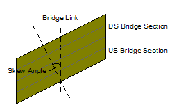
| Skew angle (degree) |
Angle of the bridge deck in relation to the centre line of the bridge link. Default value is the angle between the bridge link and the upstream face bridge section.
|
skew_angle | Double | 2 | -89.99 | 89.99 | |||||||||||||||||||||||||||||||||||||||||||||||||||||||||||||||||||||||||||||||||||||||||||||||||||||||||
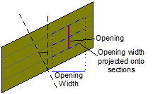
| Skew openings and piers |
If this field is checked, it is assumed that the width of openings associated with the bridge are measured along the line of the bridge section, i.e. the opening is perpendicular to the section. If this field is unchecked, it is assumed that widths are measured perpendicular to the bridge link, i.e. the opening is parallel with the river. Openings will be projected onto the bridge sections by dividing the bridge opening width by the cosine of the Skew angle. This has the effect of lengthening the bridge opening width. Any piers belonging to the opening are also projected.
|
skew_openings | Boolean | 0 | |||||||||||||||||||||||||||||||||||||||||||||||||||||||||||||||||||||||||||||||||||||||||||||||||||||||||||
| Bridge deck data |
Cross section data for deck of bridge. See US link section data |
bridge_deck | Array | ||||||||||||||||||||||||||||||||||||||||||||||||||||||||||||||||||||||||||||||||||||||||||||||||||||||||||||
| Discharge coefficient | Coefficient of discharge | discharge_coeff | Double | 2 | 1.7 | 0.01 | |||||||||||||||||||||||||||||||||||||||||||||||||||||||||||||||||||||||||||||||||||||||||||||||||||||||||
| Modular limit | The ratio (downstream depth above crest) / (upstream depth above crest) over which the bridge is assumed to be drowned. | modular_limit | Double | 2 | 0.9 | 0 | 1 | ||||||||||||||||||||||||||||||||||||||||||||||||||||||||||||||||||||||||||||||||||||||||||||||||||||||||
| DS link section data |
Cross section data for downstream end of the link. See US link section data |
ds_link_section | Array | ||||||||||||||||||||||||||||||||||||||||||||||||||||||||||||||||||||||||||||||||||||||||||||||||||||||||||||
| Expansion loss | Expansion coefficient applied to forward flow in expansion reach. | expansion_loss | Double | 2 | 0.5 | 0 | |||||||||||||||||||||||||||||||||||||||||||||||||||||||||||||||||||||||||||||||||||||||||||||||||||||||||
| Reverse flow contraction loss | Contraction coefficient applied to reverse flow in expansion reach. | reverse_expansion_loss | Double | 2 | 0.3 | 0 | |||||||||||||||||||||||||||||||||||||||||||||||||||||||||||||||||||||||||||||||||||||||||||||||||||||||||
| US expansion sediment grading |
Defines the bed material distribution at the upstream end of the expansion reach. Select a Sediment Grading from the dropdown list. InfoWorks ICM provides a default Sediment Grading, or user defined gradings may be added in the Sediment Grading Window of the Links Grid. |
us_sediment_grading_expansion | Text | 64 | 0 | Default | |||||||||||||||||||||||||||||||||||||||||||||||||||||||||||||||||||||||||||||||||||||||||||||||||||||||||
| DS expansion sediment grading |
Defines the bed material distribution at the downstream end of the expansion reach. Select a Sediment Grading from the dropdown list. InfoWorks ICM provides a default Sediment Grading, or user defined gradings may be added in the Sediment Grading Window of the Links Grid. |
ds_sediment_grading_expansion | Text | 64 | 0 | Default | |||||||||||||||||||||||||||||||||||||||||||||||||||||||||||||||||||||||||||||||||||||||||||||||||||||||||
| Limit erosion in expansion by |
Select method to be used to specify bed level at which erosion will be prevented from occurring in the expansion reach:
|
erosion_limit_type_expansion | Text | 20 | 0 | Depth | |||||||||||||||||||||||||||||||||||||||||||||||||||||||||||||||||||||||||||||||||||||||||||||||||||||||||
| Erosion depth limit in expansion |
Erosion in the expansion reach will be prevented from occurring below the depth specified, where depth is measured relative to river section invert level. A value of zero or null specifies that erosion will not occur below the original bed level. Enabled when Limit erosion by is set to Depth or Depth and level. |
erosion_depth_limit_expansion | Double | Y | 3 | 0 | 0 | ||||||||||||||||||||||||||||||||||||||||||||||||||||||||||||||||||||||||||||||||||||||||||||||||||||||||
| Erosion level limit in expansion |
Erosion in the expansion reach will be prevented from occurring below the level specified. Enabled when Limit erosion by is set to Level or Depth and level. |
erosion_level_limit_expansion | Double | Z | 3 | 0 | |||||||||||||||||||||||||||||||||||||||||||||||||||||||||||||||||||||||||||||||||||||||||||||||||||||||||
| Limit deposition depth in expansion |
Check this option to impose an upper limit on depth of sediment in expansion reach that can be deposited above the original section depth. |
limit_deposit_depth_expansion | Boolean | ||||||||||||||||||||||||||||||||||||||||||||||||||||||||||||||||||||||||||||||||||||||||||||||||||||||||||||
| Deposition limit in expansion |
Maximum allowable depth of deposition in expansion reach above the original section depth. Enabled when Limit deposition depth in expansion reach is checked. |
deposit_limit_expansion | Double | Y | 3 | 0 | 0 | ||||||||||||||||||||||||||||||||||||||||||||||||||||||||||||||||||||||||||||||||||||||||||||||||||||||||
| Bed updating in expansion |
Select the method to be used to update bed level in the expansion reach:
|
bed_updating_expansion | Text | 20 | 0 | Invert | |||||||||||||||||||||||||||||||||||||||||||||||||||||||||||||||||||||||||||||||||||||||||||||||||||||||||
| Active layer depth in expansion |
Active layer thickness in expansion reach. Applicable when Active layer depth method in Water Quality and Sediment Parameters is set to Explicit. |
aldepth_expansion | Double | Y | 0 | User Defined Defaults | 0 | ||||||||||||||||||||||||||||||||||||||||||||||||||||||||||||||||||||||||||||||||||||||||||||||||||||||||
| Active layer depth factor in expansion |
Multiplying factor for calculating active layer thickness in expansion reach. Applicable when Active layer depth method in Water Quality and Sediment Parameters is set to D50 or D90. |
aldepth_factor_expansion | Double | 0 | User Defined Defaults | 0 | |||||||||||||||||||||||||||||||||||||||||||||||||||||||||||||||||||||||||||||||||||||||||||||||||||||||||
| Limit erosion rate in expansion |
Check this option to impose an upper limit on rate of erosion in the expansion reach when modelling sediment transport. |
limit_erosion_rate_expansion | Boolean | ||||||||||||||||||||||||||||||||||||||||||||||||||||||||||||||||||||||||||||||||||||||||||||||||||||||||||||
| Max erosion rate in expansion |
Enabled if Limit erosion rate in expansion is checked. The maximum rate of erosion that will be applied in the expansion reach when modelling sediment transport. |
max_erosion_rate_expansion | Double | ERODERATE | 0 | User Defined Defaults | 0 | ||||||||||||||||||||||||||||||||||||||||||||||||||||||||||||||||||||||||||||||||||||||||||||||||||||||||
| Limit deposition rate in expansion |
Check this option to impose an upper limit on rate of deposition in the expansion reach when modelling sediment transport. |
limit_deposit_rate_expansion | Boolean | ||||||||||||||||||||||||||||||||||||||||||||||||||||||||||||||||||||||||||||||||||||||||||||||||||||||||||||
| Max deposition rate in expansion |
Enabled if Limit deposition rate in expansion is checked. The maximum rate of deposition that will be applied in the expansion reach when modelling sediment transport. |
max_deposition_rate_expansion | Double | ERODERATE | 0 | User Defined Defaults | 0 | ||||||||||||||||||||||||||||||||||||||||||||||||||||||||||||||||||||||||||||||||||||||||||||||||||||||||
|
Base Height (expansion) |
Height above invert of link. Indicates where the nominal base is with regards to the use of the two (side and base) infiltration coefficients. |
base_height_exp |
Double |
|
PS |
0 |
0.0 |
0 |
|
0 |
|
||||||||||||||||||||||||||||||||||||||||||||||||||||||||||||||||||||||||||||||||||||||||||||||||||||
|
Expansion base infiltration loss coefficient |
The rate of infiltration from the base of the bridge expansion into the ground. Applicable between the invert and the Base Height of the bridge expansion. |
infiltration_coeff_base_exp |
Double |
|
I |
2 |
0 |
0 |
|
0 |
36000 |
||||||||||||||||||||||||||||||||||||||||||||||||||||||||||||||||||||||||||||||||||||||||||||||||||||
| Expansion side infiltration loss coefficient |
The rate of infiltration from the side of the bridge expansion into the ground. Applicable above the Base Height of the bridge expansion. |
infiltration_coeff_side_exp |
Double |
|
I |
2 |
0 |
0 |
|
0 |
36000 |
||||||||||||||||||||||||||||||||||||||||||||||||||||||||||||||||||||||||||||||||||||||||||||||||||||
|
1D diffusion type (expansion) |
The type of 1D diffusion can be set to River or Estuary. The default is Estuary unless overridden by a user-defined default. Set to Estuary to calculate a diffusion coefficient that varies with tidal discharge and/or the longitudinal salinity gradient, or set to River to calculate a diffusion coefficient that is related to shear velocity. Used for 1D diffusion water quality simulations only. |
diff1_type_exp |
Text |
|
|
8 |
User Defined Default |
|
|
|
|
||||||||||||||||||||||||||||||||||||||||||||||||||||||||||||||||||||||||||||||||||||||||||||||||||||
|
1D diffusion d0 (expansion) |
If 1D diffusion type is set to Estuary, then d0 is a constant which is used to prevent unrealistically low values of dispersion from arising. If 1D diffusion type is set to River, then d0 is the minimum diffusion coefficient. The value of d0 must be ≥0 m2/s. The default is 0 m2/s unless overridden by a user-defined default. Used for 1D diffusion water quality simulations only. |
diff1_d0_exp |
Double |
|
DC |
|
User Defined Default |
|
|
|
|
||||||||||||||||||||||||||||||||||||||||||||||||||||||||||||||||||||||||||||||||||||||||||||||||||||
|
1D diffusion d1 (expansion) |
If 1D diffusion type is set to Estuary, then d1 is a constant which represents the amount of dispersion caused by tidal mixing in the estuary. If 1D diffusion type is set to River, then d1 is the shear velocity factor. The value of d1 must be ≥0 m2/s. The default is 0 m2/s unless overridden by a user-defined default.
Note
If the values d1 and d2 are zero, the diffusion coefficient is constant (the value of d0). Used for 1D diffusion water quality simulations only. |
diff1_d1_exp |
Double |
|
DC |
|
User Defined Default |
|
|
|
|
||||||||||||||||||||||||||||||||||||||||||||||||||||||||||||||||||||||||||||||||||||||||||||||||||||
|
1D diffusion d2 (expansion) |
This field is only enabled when 1D diffusion type is set to Estuary. d2 is a constant which determines the effect of salinity gradient on dispersion. The value of d2 must be ≥0 m2/s. The default is 0 m2/s unless overridden by a user-defined default.
Note
If the value of d2 is non-zero then you should ensure that SAL (salt) is specified as a determinant in the QM parameters dialog. If the values d1 and d2 are zero the diffusion coefficient is constant (the value of d0).
Used for 1D diffusion water quality simulations only. |
diff1_d2_exp |
Double | DC | User Defined Default |
|
|
|
|
||||||||||||||||||||||||||||||||||||||||||||||||||||||||||||||||||||||||||||||||||||||||||||||||||||||
| Length | Length of the bridge link | length | Double | L | 1 | 1 |
 Water Quality