Node Data Fields (InfoWorks)
A network can include different types of node: manholes, storage structures, ponds, outfalls and breaks. Information relating to a node can be viewed and edited on the Node Grid Window of the Nodes Grid or on the Node Property Sheet, which contains all the properties related to a node.
To view and edit all node data, use the Property Sheet.
The table below describes all the data which can be used to define a Node. For details of results fields for nodes, see the Node Results Data Fields topic.
 Common Data Fields
 Fields that are common to the majority of objects can be found in the Common Fields topic.
Node Data
Database Table Name: hw_node
|
Field Name |
Help Text |
Database Field |
Size |
Precision |
Default |
Error Lower Limit |
Error Upper Limit |
Warning Lower Limit |
Warning Upper Limit |
||||||||||||||||||||||||||||||||||||||||||||||||||||||
|---|---|---|---|---|---|---|---|---|---|---|---|---|---|---|---|---|---|---|---|---|---|---|---|---|---|---|---|---|---|---|---|---|---|---|---|---|---|---|---|---|---|---|---|---|---|---|---|---|---|---|---|---|---|---|---|---|---|---|---|---|---|---|---|
| Node ID | A unique name for the node, up to 30 letters, numbers and underscore characters. Upper and lower case letters are treated as being the same. | node_id | Text | 64 | 0 | ||||||||||||||||||||||||||||||||||||||||||||||||||||||||||
| Node type | Choose one of the following types of node from the drop-down menu:
|
node_type |
Text |
10 |
|
0 |
Manhole |
|
|
|
|
||||||||||||||||||||||||||||||||||||||||||||||||||||
|
Asset ID |
An optional reference - usually the asset database name for this node (if applicable). |
asset_id |
Text |
64 |
|
0 |
|
|
|
|
|
||||||||||||||||||||||||||||||||||||||||||||||||||||
|
System type |
Choose the system type from the dropdown list. See System Type for more information
|
system_type |
Text |
10 |
|
0 |
Other |
|
|
|
|
||||||||||||||||||||||||||||||||||||||||||||||||||||
|
Only enabled when Node type is set to Connect 2D. These are used to determine how flow is to be calculated when a conduit of type Conduit (2D) or Linear drainage (2D) is connected to a Connect 2D type of node. Choose the connection type from the dropdown list:
See 2D Conduits for further information. |
connection_type |
Text |
10 |
|
0 |
Lost |
|
|
|
|
|||||||||||||||||||||||||||||||||||||||||||||||||||||
|
x |
The X co-ordinate for the node position. |
x |
Double |
|
XY |
1 |
|
|
|
|
|
||||||||||||||||||||||||||||||||||||||||||||||||||||
|
y |
The Y co-ordinate for the node position. |
y |
Double |
|
XY |
1 |
|
|
|
|
|
||||||||||||||||||||||||||||||||||||||||||||||||||||
|
Ground level |
The ground level of the node, specified relative to a common datum. Not enabled when Node type is set to Connect 2D. |
ground_level |
Double |
|
Z |
3 |
|
-9999 |
9999 |
|
6000 |
||||||||||||||||||||||||||||||||||||||||||||||||||||
|
Flood level |
Level above which any water depth will be displayed as flooding. This will often be the same as ground level but you may wish to give a basement level, for example. Not enabled when Node type is set to Connect 2D. |
flood_level |
Double |
|
Z |
3 |
|
-9999 |
9999 |
|
6000 |
||||||||||||||||||||||||||||||||||||||||||||||||||||
|
Shaft additional storage: user |
Allows user defined additional storage to be applied to the manhole shaft. |
shaft_area_additional |
Double |
|
NA |
1 |
0.0 |
|
|
|
100000 |
||||||||||||||||||||||||||||||||||||||||||||||||||||
|
Shaft additional storage: compensation |
Used to apply additional storage to the shaft as part of the process of compensating for storage in unmodelled pipes. You can edit this field yourself, but we recommend that you use the Additional storage: user fields for user defined compensation. See Compensation for Unmodelled Pipes for more details |
shaft_area_add_comp |
Double |
|
NA |
1 |
|
|
|
|
100000 |
||||||||||||||||||||||||||||||||||||||||||||||||||||
|
Shaft additional storage: simplification |
Used to apply additional storage to the shaft as part of the process of merging or pruning. You can edit this field yourself, but we recommend that you use the Additional storage: user fields for user defined compensation. See Storage Compensation during Merging and Pruning for more details |
shaft_area_add_simplify |
Double |
|
NA |
1 |
|
|
|
|
100000 |
||||||||||||||||||||||||||||||||||||||||||||||||||||
|
Shaft additional storage: correction |
Used to apply additional storage to the shaft as part of the process of mathematical correction. You can edit this field yourself, but we recommend that you use the Additional storage: user fields for user defined compensation. See Preissmann Slot and Baseflow Correction for more details |
shaft_area_add_ncorrect |
Double |
|
NA |
1 |
|
|
|
|
100000 |
||||||||||||||||||||||||||||||||||||||||||||||||||||
|
Chamber additional storage: user |
Allows user defined additional storage to be applied to the manhole chamber. |
chamber_area_additional |
Double |
|
NA |
1 |
0.0 |
|
|
|
100000 |
||||||||||||||||||||||||||||||||||||||||||||||||||||
|
Chamber additional storage: compensation |
Used to apply additional storage to the chamber as part of the process of compensating for storage in unmodelled pipes. You can edit this field yourself, but we recommend that you use the Additional storage: user fields for user defined compensation. See Compensation for Unmodelled Pipes for more details |
chamber_area_add_comp |
Double |
|
NA |
1 |
|
|
|
|
100000 |
||||||||||||||||||||||||||||||||||||||||||||||||||||
|
Chamber additional storage: simplification |
Used to apply additional storage to the chamber as part of the process of merging or pruning. You can edit this field yourself, but we recommend that you use the Additional storage: user fields for user defined compensation. See Storage Compensation during Merging and Pruning for more details |
chamber_area_add_simplify |
Double |
|
NA |
1 |
|
|
|
|
100000 |
||||||||||||||||||||||||||||||||||||||||||||||||||||
|
Chamber additional storage: correction |
Used to apply additional storage to the chamber as part of the process of mathematical correction. You can edit this field yourself, but we recommend that you use the Additional storage: user fields for user defined compensation. See Preissmann Slot and Baseflow Correction for more details |
chamber_area_add_ncorrect |
Double |
|
NA |
1 |
|
|
|
|
100000 |
||||||||||||||||||||||||||||||||||||||||||||||||||||
|
Chamber roof level |
The manhole chamber area applies up to this level. Above this level, the manhole shaft area applies up to ground level. The default is the maximum of all soffit levels (of conduits or orifices connected to this node) or pump switch-on levels for wet wells or levels of other connected controls. |
chamber_roof |
Double |
|
Z |
3 |
|
-9999 |
9999 |
|
6000 |
||||||||||||||||||||||||||||||||||||||||||||||||||||
|
Chamber floor level |
The base of the manhole chamber. The chamber area applies between this level and the chamber roof. The default is either:
Where a link has both an upstream and downstream invert defined, ICM uses the invert of the one nearest the node. When a link has only a single invert then this will be used. For user-defined controls type of link, the initial level is used as the invert. For weirs, screens and siphons, ICM uses the crest as the invert. |
chamber_floor |
Double |
|
Z |
3 |
|
-9999 |
9999 |
|
6000 |
||||||||||||||||||||||||||||||||||||||||||||||||||||
|
Chamber plan area |
The manhole storage area between the chamber floor and the chamber roof. The default is calculated as:
|
chamber_area |
Double |
|
NA |
1 |
|
0 |
|
|
|
||||||||||||||||||||||||||||||||||||||||||||||||||||
|
Shaft plan area |
The manhole storage area between the chamber roof and ground level. The default is calculated as:
|
shaft_area |
Double |
|
NA |
1 |
|
0 |
|
|
|
||||||||||||||||||||||||||||||||||||||||||||||||||||
|
Flood type |
Note for Storage Nodes : Unlike manholes, storage nodes do not include any alteration of the flood cone or stage / area characteristics to account for transition. If the last stage value is below ground level, the storage node is treated as sealed. If the last value is the same as ground level then it is lost. If it is above then it is stored, in which case the flood cone rises vertically and has an area equal to the last defined plan area. Choose one of the following from the drop-down menu:
|
flood_type |
Text |
8 |
|
0 |
|
|
|
|
|
||||||||||||||||||||||||||||||||||||||||||||||||||||
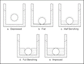
| Benching method |
Benching method options:
Access hole benching methods (Figure 7-6 FHWA HEC 22 Urban Drainage Manual) |
benching_method | Text | 13 | 0 | Full Benching | |||||||||||||||||||||||||||||||||||||||||||||||||||||||||
|
2D element area factor |
Enabled when Flood type is set to 2D or Gully 2D. Multiplying factor applied to manhole Shaft plan area to determine effective area of a 2D manhole. The effective area is used when creating a 2D mesh to ensure that flow feeding into each 2D manhole comes from a single element. Mesh triangles at each 2D manhole will be aggregated to form an element with an area that is at least the effective area of the manhole. |
element_area_factor_2d |
Double |
|
|
1 |
1 |
1 |
|
|
|
||||||||||||||||||||||||||||||||||||||||||||||||||||
|
Floodable area |
The total area that can store flood water for this node. If the default (#D) flag is set, the default value is the sum of the contributing areas of all subcatchments draining to the node. |
floodable_area |
Double |
|
CA |
3 |
|
0 |
|
|
|
||||||||||||||||||||||||||||||||||||||||||||||||||||
|
Flood depth 1 |
The depth at which the flood water spreads over flood area 1. |
flood_depth_1 |
Double |
|
Y |
1 |
|
0 |
|
|
|
||||||||||||||||||||||||||||||||||||||||||||||||||||
|
Flood depth 2 |
The depth at which the flood water spreads over flood area 2. |
flood_depth_2 |
Double |
|
Y |
1 |
|
0 |
|
|
|
||||||||||||||||||||||||||||||||||||||||||||||||||||
|
Flood area 1 (%) |
The percentage of the floodable area acting as the first part of a double conical flood storage volume. The first cone extends from the manhole area at ground level to this area at flood level 1. |
flood_area_1 |
Long Integer |
|
|
0 |
|
0 |
100 |
|
|
||||||||||||||||||||||||||||||||||||||||||||||||||||
|
Flood area 2 (%) |
The percentage of the floodable area acting as the second part of a double conical flood storage volume. The second cone extends from flood area 1 at flood level to this area at flood level 2. |
flood_area_2 |
Long Integer |
|
|
0 |
|
0 |
100 |
|
|
||||||||||||||||||||||||||||||||||||||||||||||||||||
|
Flooding discharge coefficient |
Discharge coefficient for weir flow equations used for 2D flooding nodes. |
flooding_discharge_coeff |
Double |
|
|
2 |
0.5 |
0.01 |
|
|
|
||||||||||||||||||||||||||||||||||||||||||||||||||||
|
Chamber additional storage: total |
The total from the four Chamber Additional Storage fields. See above for more information. |
chamber_area_additional_total |
Double |
|
NA |
1 |
|
|
|
|
|
||||||||||||||||||||||||||||||||||||||||||||||||||||
|
Gully head discharge table |
Add a New table or select a table from the dropdown list and click the Properties button to view the Head Discharge Table Property Sheet. Use the grid to enter the Head / Discharge pairs that define the discharge between the surface storage area and the manhole part of the node. |
head_discharge_id |
Text |
64 |
|
0 |
|
|
|
|
|
||||||||||||||||||||||||||||||||||||||||||||||||||||
|
Number of gullies |
A scaling factor used to multiply the discharge values of the Head / Discharge Table. |
n_gullies |
Double |
|
|
3 |
1 |
0 |
|
0 |
|
||||||||||||||||||||||||||||||||||||||||||||||||||||
|
Relative stages |
Check this box to define the Level values entered in the Level / Plan Area Grid as relative to Ground level. If this box is unchecked, the Level values are taken to be level above system datum. |
relative_stages |
Boolean |
|
|
0 |
False |
1 |
|
|
|
||||||||||||||||||||||||||||||||||||||||||||||||||||
|
Storage array |
If the Node type is set to Pond or Storage, then this array represents the storage capacity of the node. 
Note
When running a simulation, porosity is applied as a factor on area, but only for storage array entries that are at or below ground level. If you have a storage array with one level significantly below ground level and the next above, this may cause unexpected results.
If Node type is set to Manhole and the Flood type is set to Gully or Inlet, then this array represents the volume above the surface. The parameters for the array are entered on a Storage Array dialog which is displayed by clicking on the Database Table Name: hw_node_storage
|
storage_array |
Array |
|
|
0 |
|
0 |
0 |
0 |
0 |
||||||||||||||||||||||||||||||||||||||||||||||||||||
|
Liner level |
Level to which pond is lined. Liner infiltration coefficient will be applied between lowest stage in the Storage level array and Liner Level. Default value is the level of the lowest stage in the Perimeter array. |
liner_level |
Double |
|
Z |
3 |
0 |
|
|
|
|
||||||||||||||||||||||||||||||||||||||||||||||||||||
|
Vegetation level |
Level at which vegetation starts. Vegetation infiltration coefficient will be applied above the Vegetation level. Default value is the invert of the lowest attached link. |
vegetation_level |
Double |
|
Z |
3 |
0 |
|
|
|
|
||||||||||||||||||||||||||||||||||||||||||||||||||||
|
Infiltration loss coefficient above vegetation |
The rate of infiltration from the pond into the ground, applicable above the Vegetation level of the pond. Default value is value of Infiltration coefficient above liner. |
infiltratn_coeff_abv_vegn |
Double |
|
I |
2 |
|
0 |
|
0 |
36000 |
||||||||||||||||||||||||||||||||||||||||||||||||||||
|
Infiltration loss coefficient above liner |
The rate of infiltration from the pond into the ground, applicable between the Liner level and the Vegetation level of the pond. Default value is 0. |
infiltratn_coeff_abv_liner |
Double |
|
I |
2 |
0 |
0 |
|
0 |
36000 |
||||||||||||||||||||||||||||||||||||||||||||||||||||
|
Infiltration loss coefficient below liner |
The rate of infiltration from the pond into the ground, applicable below the Liner level. Default value is 0. |
infiltratn_coeff_blw_liner |
Double |
|
I |
2 |
0 |
0 |
|
0 |
36000 |
||||||||||||||||||||||||||||||||||||||||||||||||||||
|
Base area |
The area of the base of the SUDS structure. This is the area through which water infiltrates into the ground from a 2d structure Used for modelling SUDS structures |
base_area |
Double |
|
NA |
2 |
|
0 |
|
0 |
|
||||||||||||||||||||||||||||||||||||||||||||||||||||
|
Perimeter |
The perimeter length for the SUDS structure. All 2d structures will have a Perimeter of 0 because no infiltration takes place through the sides of the structure. For 3d structures, the Perimeter * structure depth represent the area for infiltration through the sides. The actual area for infiltration at any point in the simulation is Base Area + (Perimeter * water level in the structure). Used for modelling SUDS structures |
perimeter |
Double |
|
L |
3 |
0 |
0 |
|
0 |
|
||||||||||||||||||||||||||||||||||||||||||||||||||||
|
Infiltration loss Coefficient |
The rate of infiltration from the structure into the ground. Infiltration is given by Actual Infiltration Area * Infiltration Coefficient. Used for modelling SUDS structures |
infiltration_coeff |
Double |
|
I |
2 |
0 |
0 |
|
0 |
|
||||||||||||||||||||||||||||||||||||||||||||||||||||
|
Porosity |
Some SUDS structures are filled with stones or gravel for example. The Porosity represents this infill. A Porosity of 0.3 represents 30% air volume in the structure (70% of the volume is taken up by fill material). This infill will affect the water level in the structure. Used for modelling SUDS structures |
porosity |
Double |
|
|
3 |
1 |
0.001 |
1 |
0.001 |
1 |
||||||||||||||||||||||||||||||||||||||||||||||||||||
|
Inlet type |
Type of inlet being modelled:
|
inlet_type |
Text |
30 |
|
0 |
SagC |
|
|
|
|
||||||||||||||||||||||||||||||||||||||||||||||||||||
|
Inlet input type |
Calculation option for inlet:
|
inlet_input_type |
Text |
30 |
|
0 |
Params |
|
|
|
|
||||||||||||||||||||||||||||||||||||||||||||||||||||
|
Inlet head discharge table |
Select an existing Head Discharge Table from the dropdown list or click the arrow button to create a new table. Head / Discharge pairs define the discharge between the surface storage area and the manhole part of the node. Required for inlet nodes when Inlet input type is set to HeadD. |
head_discharge_id |
Text |
64 |
|
0 |
|
|
|
|
|
||||||||||||||||||||||||||||||||||||||||||||||||||||
|
Inlet flow efficiency table |
Select an existing Flow Efficiency Table from the dropdown list or click the arrow button to create a new table. Flow / Efficiency pairs define the efficiency of interception of flow at the node at varying flow values. Required for inlet nodes when Inlet input type is set to FlowEff. |
flow_efficiency_id |
Text |
64 |
|
0 |
|
|
|
|
|
||||||||||||||||||||||||||||||||||||||||||||||||||||
|
User equation A value |
Required when Inlet input type is set to EQU. Constant used in equation to calculate flow through inlet: Q=ayb Where: Q = flow a = constant defined in User equation A value field y = depth of flow at inlet b = constant defined in User equation B value field |
inlet_UE_a |
Double |
|
|
3 |
0.000 |
0 |
|
0 |
|
||||||||||||||||||||||||||||||||||||||||||||||||||||
|
User equation B value |
See User equation A value |
inlet_UE_b |
Double |
|
|
3 |
0.000 |
0 |
|
0 |
|
||||||||||||||||||||||||||||||||||||||||||||||||||||
| Cross slope |
Rate of change of roadway elevation with respect to distance perpendicular to the direction of travel. Also known as transverse slope. Required for inlet nodes when Inlet input type is set to Params. |
cross_slope |
Double |
|
|
3 |
0.000 |
0 |
|
0 |
|
||||||||||||||||||||||||||||||||||||||||||||||||||||
| Grate width |
Grate dimension Required for Inlet type of Continuous grate, Sag grate, Sag combination and UPC grate when Inlet input type is set to Params. |
grate_width |
Double |
|
L |
3 |
0.000 |
0 |
|
0 |
|
||||||||||||||||||||||||||||||||||||||||||||||||||||
| Grate length |
Grate dimension Required for Inlet type of Continuous grate, Sag grate, Sag combination and UPC grate when Inlet input type is set to Params. |
grate_length |
Double |
|
L |
3 |
0.000 |
0 |
|
0 |
|
||||||||||||||||||||||||||||||||||||||||||||||||||||
| Gutter depression |
Depth of gutter depression. Used when modelling a depressed inlet. Required for Inlet type of Sag curb-opening and Continuous curb-opening when Inlet input type is set to Params. |
gutter_depression |
Double |
|
L |
3 |
0.000 |
0 |
|
0 |
|
||||||||||||||||||||||||||||||||||||||||||||||||||||
| Opening length |
Length of curb opening. Required for Inlet Type of Continuous Curb-Opening, Sag Curb-Opening and Sag Combination when Inlet Input Type is set to Params. |
opening_length |
Double |
|
L |
3 |
0.000 |
0 |
|
0 |
|
||||||||||||||||||||||||||||||||||||||||||||||||||||
| Opening height |
Height of curb opening. Required for Inlet Type of Sag Curb-Opening and Sag Combination when Inlet Input Type is set to Params. |
opening_height |
Double |
|
L |
3 |
0.000 |
0 |
|
0 |
|
||||||||||||||||||||||||||||||||||||||||||||||||||||
| Lateral depression |
Lateral width of gutter depression. Used when modelling a depressed inlet. Required for Inlet type of Sag curb-opening and Continuous curb-opening when Inlet input type is set to Params. |
lateral_depression |
Double |
|
L |
3 |
0.000 |
0 |
|
0 |
|
||||||||||||||||||||||||||||||||||||||||||||||||||||
| Splashover velocity |
Velocity at which water first begins to splash over inlet grate. Required for Inlet type of Continuous grate when Inlet input type is set to Params. |
velocity_splashover |
Double |
|
V |
3 |
0.000 |
0 |
|
0 |
|
||||||||||||||||||||||||||||||||||||||||||||||||||||
| Weir behaviour depth |
Depth of water up to which grate inlet behaves as a weir. Above this depth the inlet will be modelled as an orifice. Required for all Sag inlet types when Inlet input type is set to Params. Default set to 1.4 x Opening height for Inlet type of Sag curb-opening and Sag combination. Default set to 0.0 for Inlet type of Sag grate. |
depth_weir |
Double |
|
L |
3 |
0.000 |
0 |
|
0 |
|
||||||||||||||||||||||||||||||||||||||||||||||||||||
| % Clogging |
Factor used to model the effect of clogging from debris. Represents percentage reduction in the width of the grate when Inlet type is Sag grate or Sag combination. Represents percentage reduction in flow when Inlet type is Continuous grate. |
debris |
Double |
|
|
3 |
0.000 |
0 |
|
0 |
|
||||||||||||||||||||||||||||||||||||||||||||||||||||
| Clear opening |
Clear area of grate or opening. Required for all Sag inlet types when Inlet input type is set to Params. |
clear_opening |
Double |
|
NA |
3 |
0.000 |
0 |
|
0 |
|
||||||||||||||||||||||||||||||||||||||||||||||||||||
| Area of voids |
Area of grate voids. Required when Inlet type is UPC grate and Inlet input type is set to Params. |
area_of_voids | Double | NA | 0 | ||||||||||||||||||||||||||||||||||||||||||||||||||||||||||
| Minimum area including voids |
Area of smallest rectangle having sides parallel to the kerb containing all the void areas of the grate (including the area occupied by the bars). Required when Inlet type is UPC grate and Inlet input type is set to Params. |
min_area_inc_voids | Double | NA | 0 | ||||||||||||||||||||||||||||||||||||||||||||||||||||||||||
| Number of transverse bars |
Number of grate bars perpendicular to the kerb. Required when Inlet Type is UPC grate and Inlet input type is set to Params. |
num_transverse_bars | Long Integer | 0 | 0 | 255 | |||||||||||||||||||||||||||||||||||||||||||||||||||||||||
| Number of diagonal bars |
Number of grate bars diagonal to the kerb. Required when Inlet type is UPC grate and Inlet input type is set to Params. |
num_diagonal_bars | Long Integer | 0 | 0 | 255 | |||||||||||||||||||||||||||||||||||||||||||||||||||||||||
| Number of longitudinal bars |
Number of grate bars parallel to the kerb. Required when Inlet type is UPC Grate and Inlet Input Type is set to Params. |
num_longitudinal_bars | Long Integer | 0 | 0 | 255 | |||||||||||||||||||||||||||||||||||||||||||||||||||||||||
| Half road width |
Half the full width of the road (it is assumed that there will be gullies along both kerbs). Required when Flood type is Inlet 2D, Inlet type is UPC grate and Inlet input type is set to Params. |
half_road_width | Double | L | 3 | ||||||||||||||||||||||||||||||||||||||||||||||||||||||||||
|
InfoAsset Unique ID |
Unique ID associated with the corresponding object in an InfoAsset Manager database. When importing from InfoAsset Manager, the InfoAsset Unique ID can be copied from the InfoAsset Manager database in order to maintain links between the two networks. |
asset_uid |
GUID |
|
|
0 |
|
0 |
0 |
0 |
0 |
||||||||||||||||||||||||||||||||||||||||||||||||||||
| InfoAsset ID |
Used to store the ID of the corresponding InfoAsset Manager object when Importing from a Collection Network. |
infonet_id | Text | 40 | 0 | ||||||||||||||||||||||||||||||||||||||||||||||||||||||||||
| 1D-2D linkage basis |
Choose the basis for the transfer of flow from the drop-down list:
If left blank, the setting of Use 2d elevations instead of depths field in the simulation parameters is used. |
2d_link_type | Text | 12 | 0 | Depth |
 button.