Spatial Data Analysis Wizard - Allocate Page

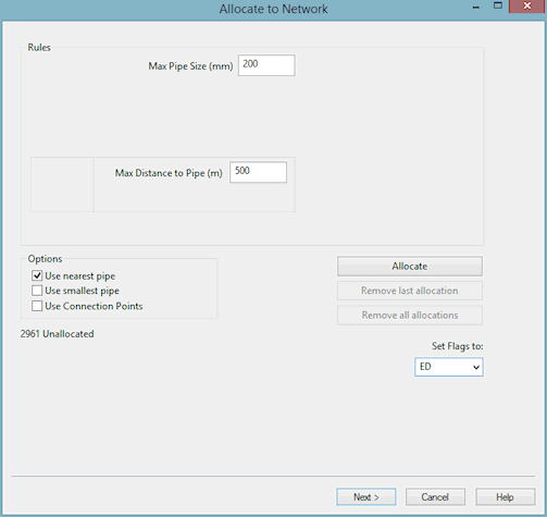
The Allocate Page of the Spatial Data Analysis Wizard is used to set rules and options for allocating spatial data points to pipes in the network.

The allocation process is iterative. You can:

  1. allocate spatial data points
  2. see the summary of results
  3. view the effects on the GeoPlan Window
  4. change the allocation rules and try again

Unallocated items can then be reviewed on the Unallocated Page. It is possible to return to this page from the Unallocated Page to try allocation again.

For each customer point, InfoWorks uses the Rules settings to create a list of available pipes for use with allocation.

Note that a value of zero for the Max Pipe Size or Max Distance to Pipe rules, is taken to mean that the rule should not be used in the allocation process.

ClosedShow image

Rules

Max Pipe Size

Pipes with a larger diameter than the specified diameter will be excluded from the allocation process.

Max Distance to Pipe

If the distance to the nearest point on a pipe from the customer point exceeds the specified distance, the spatial data point will not be allocated.

Options

Use nearest pipe

Check this option for spatial data to be allocated to nearest pipe to the spatial data point that satisfies the above rules.

If neither the nearest pipe option or the smallest pipe option is selected, InfoWorks will allocate spatial data to any pipe that satisfies the above rules.

Use smallest pipe

Check this option for spatial data to be allocated to the pipe with smallest diameter that satisfies the above rules.

If neither the nearest pipe option or the smallest pipe option is selected, InfoWorks will allocate spatial data to any pipe that satisfies the above rules.

Buttons

Allocate

Attempts to allocate the demand using the above Rules and Options. When the allocation is complete, the Rules box will contain additional information about how the rules that have been applied have affected the allocation process.

Remove last allocation

Clears allocations carried out from the last click of the Allocate button

Remove all allocations

Removes all allocations for the current set of points. This is the list that was displayed on the Review Page. Allocations from previous uses of the wizard will not be displayed unless the Reallocate options on the Start Page have been selected.

Set Flags to:

Select a flag from the dropdown list if required. This will flag the Allocated Pipe ID field of successfully allocated points. This can be viewed in the Spatial Data Grid or the Spatial Data Property Sheet of individual spatial data points.

Finally

Click Next. A progress bar entitled Scanning Unallocated Items may appear. This then displays the Unallocated Page of the wizard.

You can switch back to this page from the Unallocated Page if you want to try different allocation rules.


Spatial Data Analysis Wizard

Processing Spatial Data

Spatial Data

Spatial Data Analysis Wizard - Start Page

Spatial Data Analysis Wizard - Acquisition Page

Spatial Data Analysis Wizard - Review Page

Spatial Data Analysis Wizard - Pre-Allocate Page

Spatial Data Analysis Wizard - Unallocated Page

Spatial Data Analysis Wizard - Apply Page