2D Zone Results Data Fields

Time varying results for 2D Zone mesh elements are displayed
on the
Results for 2D Zone mesh elements are displayed on the 2D Zone Mesh Element Properties Dialog. Time varying results are shown with the field name in an alternate colour on the grid and property sheets. For all time varying results a Max and Min result displaying the value of the maximum and minimum value reached during the simulation will also be displayed. Non-time varying results have the field name in the normal black type.
Time varying and summary results can be exported to csv file.
Database Table Name: __IWR_2DZone
|
Field Name |
Help Text |
Database Field |
Time Varying | |
|---|---|---|---|---|
|
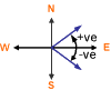
Direction |
Direction of flow. Angle in radians from due East.
|
ANGLER |
ANGLE2D |
True |
|
Depth |
Depth of water |
Y |
DEPTH2D |
True |
| Cumulative infiltration |
Cumulative infiltration depth. Only displayed when an infiltration surface is associated with the 2D Zone. See 2D Infiltration Model for further information. |
Y | CUMINF2D | True |
| Eddy viscosity | The eddy viscosity during simulation. | VI | EDDYVISCOSITY2D | True |
| Effective infiltration |
Effective infiltration rate (derived from Cumulative infiltration result). Only displayed when an infiltration surface is associated with the 2D Zone. See 2D Infiltration Model for further information. |
I | EFFINF2D | True |
|
Elevation |
Elevation of 2D element at time t, calculated as: elevation(t) = depth(t) + ground level When carrying out a Water Quality simulation including modelling of 2D erosion-deposition, elevation is calculated as: elevation(t) = depth(t) + level active layer(t) No value is shown when the element is dry. |
Z |
elevation2d |
True |
|
Froude number |
Froude Number of 2D element at time t, is calculated as: Fr(t) = velocity(t) /√(g+depth(t)) If depth(t) = 0 then Fr(t) = 0 Fr(t) is always > 0 |
|
froude2d |
True |
| Green-Ampt Saturation flag |
Indicates whether or not the soil for that element has reached saturation point: 1 = saturated 0 = unsaturated Only displayed when an infiltration surface using the Green-Ampt model is associated with the 2D Zone. |
|
GASFLAG2D | True |
| Green-Ampt moisture content of the upper zone |
The soil moisture content of the upper zone. Only displayed when an infiltration surface using the Green-Ampt model is associated with the 2D Zone. |
Y |
GAMCUZ2D | True |
| Green-Ampt Soil moisture deficit (%) |
The soil moisture deficit. Only displayed when an infiltration surface using the Green-Ampt model is associated with the 2D Zone. If the soil moisture deficit falls below zero during a simulation, the soil moisture deficit is automatically reset to zero. |
GASMD2D | True | |
| Green-Ampt Time needed to drain upper zone |
The time taken to drain upper zone. Only displayed when an infiltration surface using the Green-Ampt model is associated with the 2D Zone. |
TS | GATDUZ2D | True |
| Infiltration potential |
Potential infiltration rate. Only displayed when an infiltration surface using the Horton model is associated with the 2D Zone. See 2D Infiltration Model for further information. |
I | POTINF2D | True |
|
Speed |
Velocity of water |
V |
SPEED2D |
True |
| Soil water content percentage |
Soil water content. Only displayed when an infiltration surface using the Horton model is associated with the 2D Zone. See 2D Infiltration Model for further information. |
SWCP2D | True | |
|
Unit flow |
Flow per unit length in 2D element. Unit Flow at time t, is calculated as: f(t) = depth(t) x speed(t) |
UQ |
unitflow2d |
True |
| Direction at first max velocity | Flow direction at first occurrence of maximum velocity. | ANGLER | MAXANGLE2D | False |
| Direction at first min velocity | Flow direction at first occurrence of minimum velocity. This field is undefined if minimum velocity is zero. | ANGLER | MINANGLE2D | False |
| Direction at first max hazard | Flow direction at first occurrence of maximum hazard. | ANGLER | MAXHAZANGLE2D | False |
| Depth at first max hazard | Depth at first occurrence of maximum hazard. | Y |
MAXHAZDEPTH2D |
False |
| Speed at first max hazard | Velocity at first occurrence of maximum hazard. | V |
MAXHAZSPEED2D |
False |
| Direction at first max depth | Flow direction at first occurrence of maximum depth | ANGLER | MAXDEPTHANGLE2D | False |
| Direction at first max velocity above threshold | Flow direction at first occurrence of maximum velocity if it occurs when the depth is above the inundation threshold. Otherwise, this field is undefined. | ANGLER | MAXVELDEPTHANGLE2D | False |
|
Mesh element area |
Area of 2D element. |
NA |
AREA2D |
False |
|
Element level |
Ground level of 2D element. If ground level modification has been applied via Mesh Zone, this is the adjusted ground level. |
Z |
GNDLEV2D |
False |
|
Max hazard |
Maximum Flood Hazard Rating value during simulation. Flood Hazard Rating is calculated using the DEFRA Hazard formula presented in technical reports FD2320/TR2 and FD2321/TR1: HR = d x (v + 0.5) + DF Where: d = depth of flooding (m) v = velocity of floodwaters (m/s) DF = Debris Factor Where Debris Factor is assumed to be:
as used in Table 4 of the document: Explanatory Note for FD2320 and FD2321 |
HAZARD2D |
False |
|
|
Rainfall profile |
Rainfall profile that has been assigned to the mesh element |
RAINPROF2D |
False |
|
| Time to last inundation |
Time (from start of simulation) at which depth exceeds the Inundation mapping depth threshold for the last time during the simulation. The Inundation mapping depth threshold is specified on the Advanced tab of the 2D Parameters Dialog when scheduling a run. Set to -1 if the depth threshold is not met. |
TS | T_END_INUNDATION_2D | False |
| Total inundation duration |
Total time over which depth exceeds the Inundation mapping depth threshold during the simulation. The Inundation mapping depth threshold is specified on the Advanced tab of the 2D Parameters Dialog when scheduling a run. Set to -1 if the depth threshold is not met. |
TS | T_FLOOD_DURATION_2D | False |
|
Time to first inundation |
Time (from start of simulation) at which depth first exceeds the Inundation mapping depth threshold specified on the Advanced tab of the 2D Parameters Dialog when scheduling a run. Set to -1 if the depth threshold is not met. |
TS |
T_INUNDATION_2D |
False |
|
Time to peak inundation |
Time (from start of simulation) when the Max Depth in the element is first achieved. Set to -1 if the depth in the element is zero throughout the simulation. |
TS |
T_PEAK_2D |
False |
| Concentration <CFX> dissolved 2D |
Concentration of dissolved pollutant, where <CFX> represents the coliform pollutant name. Only displayed when carrying out a Water Quality simulation. |
MCSI | MC<CFX>DIS2D | True |
| Concentration <PPP> dissolved 2D |
Concentration of dissolved pollutant, where <PPP> represents the pollutant name. Only displayed when carrying out a Water Quality simulation. |
MCSI | MC<PPP>DIS2D | True |
| Concentration <PPP> detrital |
Concentration of detrital pollutant, where <PPP> represents the pollutant name. Only displayed when carrying out a Water Quality simulation. |
MCSI | MC<PPD>DET2D | True |
| Concentration <CFX> <SFX> 2D |
Concentration of pollutant by sediment fraction, where <CFX> represents the coliform pollutant name and <SFX> represents the sediment fraction name. Only displayed when carrying out a Water Quality simulation. |
MCSI | MC<CFX><SFX>2D | True |
| Concentration <PPP> <SFX> 2D |
Concentration of pollutant by sediment fraction, where <PPP> represents the pollutant name and <SFX> represents the sediment fraction name. Only displayed when carrying out a Water Quality simulation. |
MCSI | MC<PPP><SFX>2D | True |
| Concentration <SFX> 2D |
Concentration of sediment fraction, where <SFX> represents the sediment fraction name. Only displayed when carrying out a Water Quality simulation. |
MCSI | MC<SFX>2D | True |
| Saturated DO 2D |
Concentration of saturated dissolved oxygen. Only displayed when carrying out a Water Quality simulation including modelling of Dissolved Oxygen. |
MCSI | DO_SAT2D | True |
| Coliforms 2D | Concentration of coliforms. | MCCOLDDIS2D | True | |
| pH 2D | pH | PH2D | True | |
| Water temperature 2D | Temperature of water. | CF | TW2D | True |
| Unionised NH3 2D | Unionised ammoniacal nitrogen. | MCSI | UNNH32D | True |
| Dimensionless <SFX> concentration |
Dimensionless concentration of sediment fraction as m3 of sediment per m3 of water sediment mixture, where <SFX> represents sediment fraction. Calculated as: Concentration <SFX> / Density <SFX> Where, density of sediment fraction is specified in the Water Quality and Sediment Parameters. Only displayed when carrying out 2D Water Quality Simulations. |
AC<SFX>2D | True | |
| Dimensionless sediment concentration |
Sum of all Dimensionless sediment concentration values over all sediment fractions. Only displayed when carrying out 2D Water Quality Simulations. |
AC2D | True | |
| Combined carrying capacity |
Compound carrying capacity of flow for dependent sediment fractions. Only displayed when carrying out 2D Water Quality Simulations including modelling of dependent sediment fractions. |
DENSITY | CC2D | True |
| Carrying capacity <SFX> |
Carrying capacity of flow for each sediment fraction, where <SFX> represents the sediment fraction. Only displayed when carrying out 2D Water Quality Simulations. |
DENSITY | CC<SFX>2D | True |
| Compacted depth <BSL> layer |
Compacted depth of each sediment layer without taking into consideration the porosity of the sediment fractions, where <BSL> represents the bed sediment layer. Only displayed when carrying out 2D Water Quality Simulations. |
Y | COMPDEP<BSL>2D | True |
| Sediment depth |
Total sediment depth calculated as the sum of Sediment depth values over all sediment fractions. Only displayed when carrying out 2D Water Quality Simulations. |
Y | DPT2D | True |
| Sediment depth <SFX> |
Sediment depth of sediment fraction, where <SFX> represents the sediment fraction. Only displayed when carrying out 2D Water Quality Simulations. |
Y | DPT<SFX>2D | True |
| Deposited sediment depth |
Total deposited sediment depth calculated as sum of Deposited sediment depth values over all sediment fractions. Only displayed when carrying out 2D Water Quality Simulations. |
Y | INCD2D | True |
| Deposited sediment depth <SFX> |
Total depth of sediment deposited since start of simulation for each sediment fraction, where <SFX> represents sediment fraction. Calculated as: Sediment depth <SFX> (t) - Sediment depth <SFX> (t0) Only displayed when carrying out 2D Water Quality Simulations. |
Y | INCD<SFX>2D | True |
| Total deposited sediment depth due to bed load |
Total depth of sediment deposited due to bed load calculated as sum of Deposited sediment depth due to bed load values over all sediment fractions. Only displayed when carrying out 2D Water Quality Simulations. |
Y | INCDBL2D | True |
| Deposited sediment depth <SFX> due to bed load |
Total depth of sediment deposited due to bed load since start of simulation for each sediment fraction, where <SFX> represents the sediment fraction. Only displayed when carrying out 2D Water Quality Simulations. |
Y | INCDBL<SFX>2D | True |
| Total deposited sediment depth due to suspended load |
Total depth of sediment deposited due to suspended load calculated as sum of Deposited sediment depth due to suspended load values over all sediment fractions. Only displayed when carrying out 2D Water Quality Simulations. |
Y | INCDSL2D | True |
| Deposited sediment depth <SFX> due to suspended load |
Total depth of sediment deposited due to suspended load since start of simulation for each sediment fraction, where <SFX> represents the sediment fraction. Only displayed when carrying out 2D Water Quality Simulations. |
Y | INCDSL<SFX>2D | True |
| Total net erosion rate due to bed load |
Total net erosion rate due to bed load calculated as sum of Net erosion rate due to bed load values over all sediment fractions. Only displayed when carrying out 2D Water Quality Simulations. |
ERODERATE | ERBL2D | True |
| Net erosion rate <SFX> due to bed load |
Net erosion rate due to bed load per sediment fraction, where <SFX> represents the sediment fraction. Calculated as: (Dbed <SFX> (t-1) - Dbed <SFX> (t))/(results timestep) Where Dbed is Deposited sediment depth due to bed load. Only displayed when carrying out 2D Water Quality Simulations. |
ERODERATE | ERBL<SFX>2D | True |
| Total net erosion rate due to suspended load |
Total net erosion rate due to suspended load calculated as sum of Net erosion rate due to suspended load values over all sediment fractions. Only displayed when carrying out 2D Water Quality Simulations. |
ERODERATE | ERSL2D | True |
| Net erosion rate <SFX> due to suspended load |
Net erosion rate due to suspended load per sediment fraction, where <SFX> represents the sediment fraction. Calculated as: (Dsus <SFX> (t-1) - Dsus <SFX> (t))/(results timestep) Where Dsus is Deposited sediment depth due to suspended load. Only displayed when carrying out 2D Water Quality Simulations. |
ERODERATE | ERSL<SFX>2D | True |
| Total net erosion rate |
Total net erosion rate calculated as the sum of Net erosion rate values over all sediment fractions. Only displayed when carrying out 2D Water Quality Simulations. |
ERODERATE | ER2D | True |
| Net erosion rate <SFX> |
Net erosion rate per sediment fraction, where <SFX> represents the sediment fraction. Calculated as: (Sediment depth <SFX>(t-1) - Sediment depth <SFX> (t))/(results timestep) Only displayed when carrying out 2D Water Quality Simulations. |
ERODERATE | ER<SFX>2D | True |
| Non-erodible level |
Level of non-erodible layer above datum. Only displayed when carrying out 2D Water Quality Simulations. |
Z | LEVEL_NE2D | False |
| Level <BSL> layer |
Level of bed sediment layer above datum, where <BSL> represents the bed sediment layer. Only displayed when carrying out 2D Water Quality Simulations. |
Z | LEVEL<BSL>2D | True |
| Rouse number <SFX> |
Rouse number of sediment fraction, where <SFX> represents the sediment fraction. Only displayed when carrying out 2D Water Quality Simulations. |
RN<SFX>2D | True | |
| Rouse number |
Rouse number. Only displayed when carrying out 2D Water Quality Simulations. |
RN2D | True | |
| Shear stress <SFX> |
Shear stress of sediment fraction, where <SFX> represents the sediment fraction. Only displayed when carrying out 2D Water Quality Simulations. |
SHEARSTRESS | TAU<SFX>2D | True |
| Shear stress |
Only displayed when carrying out 2D Water Quality Simulations. |
SHEARSTRESS | TAU2D | True |
| Transport parameter <SFX> |
Transport parameter of sediment fraction, where <SFX> represents sediment fraction. Only displayed when carrying out 2D Water Quality Simulations. |
TP<SFX>2D | True | |
| Transport parameter |
Transport parameter. Only displayed when carrying out 2D Water Quality Simulations. |
TP2D | True | |
| Volume concentration <SFX> <BSL> layer |
Volume concentration of each sediment fraction in each sediment layer, where <SFX> represents the sediment fraction and <BSL> represents the bed sediment layer. Only displayed when carrying out 2D Water Quality Simulations. |
VC<SFX><BSL>2D | True | |
| InfoWorks CS element ID |
ID used to identify the triangles that have been aggregated into larger elements in order to meet the minimum element area of the triangle's 2D Zone or mesh zone. An InfoWorks CS element ID of zero indicates that the triangle has not been aggregated. A non zero value indicates that the triangle has been aggregated; the other triangles that it is aggregated with will be given the same InfoWorks CS element ID. Only generated for networks containing meshes that have been imported from InfoWorks CS or SD. Note: The import of InfoWorks CS/SD data is deprecated from version 2023.1. However, this result will still be available for data imported using an earlier version of the software. If a network contains meshes that were created in InfoWorks ICM as well as meshes created in InfoWorks CS or SD, then elements in those meshes created in InfoWorks ICM will be given a blank InfoWorks CS Element ID, regardless of the aggregation. If there are no InfoWorks CS or SD meshes in the network, then this result will not be generated at all. Aggregation of meshes created in InfoWorks ICM can instead be viewed using the control settings on the Elements tab of the Geoplan Properties dialog. |
virtual2d | False | |
| Volume error |
The volume error accumulated at the 2D Zone element during the simulation. |
VO | VOLERROR2D | False |