Runoff Surface Data Fields (InfoWorks)
Runoff Surface data can be edited on either the Runoff Surface Grid Window of the Subcatchments Grid or the Runoff Surface Property Sheet.
Most data can be edited on the grid, but some fields cannot be displayed in the grid format.
To view and edit all runoff surface data, use the Property Sheet.
The following describes all the data which can be used to define a runoff surface.
 Common Data Fields
 Fields that are common to the majority of objects can be found in the Common Fields topic.
Runoff Surface Data
Database Table Name: hw_runoff_surface
|
Show Columns |
Database Names |
|
Size, Type and Units |
|
|
Defaults and Error Limits |
|
Field Name |
Help Text |
Database Field |
Size |
Precision |
Default |
Error Lower Limit |
Error Upper Limit |
Warning Lower Limit |
Warning Upper Limit |
||||||||||||||||||||||||||||||||||||||||||
|---|---|---|---|---|---|---|---|---|---|---|---|---|---|---|---|---|---|---|---|---|---|---|---|---|---|---|---|---|---|---|---|---|---|---|---|---|---|---|---|---|---|---|---|---|---|---|---|---|---|---|---|
|
Runoff surface ID |
An integer that identifies this runoff surface. Each surface ID must be unique. |
runoff_index |
Long Integer |
|
|
0 |
|
1 |
99999 |
|
|
||||||||||||||||||||||||||||||||||||||||
| Description | Description of Runoff Surface. Maximum 80 characters. | surface_description | Text | 80 | 0 | ||||||||||||||||||||||||||||||||||||||||||||||
| Surface type |
|
surface_type | Text | 10 | 0 | Unknown | |||||||||||||||||||||||||||||||||||||||||||||
| Routing model |
Further information on these routing models is given in the Runoff routing models section.
|
routing_model | Text | 10 | 0 | ||||||||||||||||||||||||||||||||||||||||||||||
| User-specified RAFTS B |
A check (x) in the box indicates that the RAFTS B value to be used by InfoWorks ICM is specified by the user in the Runoff routing value field. An unchecked box indicates that InfoWorks ICM calculates the RAFTS B value. See the RAFTS Routing Model for details about how this is calculated. |
rafts_user_b | Boolean | ||||||||||||||||||||||||||||||||||||||||||||||||
| Runoff routing type |
Choose one of the following. This determines the nature of the runoff routing value you give.
|
runoff_routing_type | Text | 10 | 0 | ||||||||||||||||||||||||||||||||||||||||||||||
| Runoff routing value |
This is either the storage delay time coefficient (RAFTS B), or depending on the runoff routing type you chose it is:
When using SWMM routing, the value represents the Manning roughness, regardless of the type. When using Kadoya routing, the value represents the Kadoya C value, regardless of the type. When using RAFTS routing, this field is editable if the User-specified RAFTS B box is checked, enabling you to specify the RAFTS B value to be used. If unchecked, the RAFTS B value is calculated by InfoWorks ICM. See the RAFTS Routing Model for details about how this is calculated. |
runoff_routing_value | Double | 3 | 0 | ||||||||||||||||||||||||||||||||||||||||||||||
| Ground slope |
InfoWorks ICM uses the ground slope when calculating runoff rate and initial losses. If a value is not entered, or a value of zero is entered, InfoWorks ICM will attempt to obtain a value for slope in the following ways:
((ground level at node to which subcatchment is attached) - (ground level at d/s node of .1 link from node to which subcatchment is attached)) / length of .1 link from node to which subcatchment is attached |
ground_slope | Double | S | 6 | 0 | 1 | 0.1 | |||||||||||||||||||||||||||||||||||||||||||
| Runoff volume type |
Choose a runoff volume model from the drop-down menu. Further information on these routing models is given in the Runoff volume models section.
|
runoff_volume_type | Text | 10 | 0 | ||||||||||||||||||||||||||||||||||||||||||||||
| Initial abstraction factor |
The quantity of rainfall required to just cause overland flow is the initial loss. The initial part of a rainstorm is assumed to cause no runoff because it is lost in wetting the ground surface and in forming puddles. This field is only enabled if you set the Initial loss type field to SCS, and its value represents:
|
initial_abstraction_factor | Double | 8 | 0 | 0 | |||||||||||||||||||||||||||||||||||||||||||||
| Fixed runoff coefficient |
This is a proportion. For example, 0.1 indicates 10% runoff from this surface. Used for Runoff volume type of Fixed or ConstInf. |
runoff_coefficient | Double | 5 | 0 | 1 | |||||||||||||||||||||||||||||||||||||||||||||
| Maximum deficit |
Amount of water that the soil layer can hold (depth). Used for Runoff volume type of DefConLoss |
maximum_deficit | Double | RD | 1 | 0 | |||||||||||||||||||||||||||||||||||||||||||||
| Infiltration loss coefficient |
Used to calculate the infiltration loss when Runoff volume type is set to ConstInf. See Sustainable Urban Drainage Systems for more information. Infiltration rate when soil layer is saturated when runoff volume type is set to DefConLoss. |
infiltration_coeff | Double | I | 1 | 0 | 0 | ||||||||||||||||||||||||||||||||||||||||||||
| Green Ampt conductivity |
The minimum or asymptotic infiltration rate of the soil. This is equivalent to limiting infiltration rate in Horton. Used when Runoff volume type is set to GreenAmpt. |
saturated_hydraulic_conductivity | Double | R | 1 | 0 | |||||||||||||||||||||||||||||||||||||||||||||
| Green Ampt suction |
This is the average capillary suction at the wetting front. It depends on the soil type. Typical values in mm:
Used when Runoff volume type is set to GreenAmpt. |
average_capillary_suction | Double | RD | 1 | 0 | |||||||||||||||||||||||||||||||||||||||||||||
| Horner alpha |
Parameter used to define loss coefficient. Used when Runoff volume type is set to Horner. |
halpha | Double | 2 | 0 | 1 | |||||||||||||||||||||||||||||||||||||||||||||
| Horner beta |
Parameter used to define loss coefficient. Used when Runoff volume type is set to Horner. |
hbeta | Double | 2 | 0 | 5 | |||||||||||||||||||||||||||||||||||||||||||||
| Horner recovery (min) |
Time to recover to initial conditions. Used when Runoff volume type is set to Horner. |
hrecovery | Double | 1 | 50 | 0 | |||||||||||||||||||||||||||||||||||||||||||||
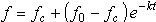
| Decay factor (1/hour) |
Exponential term (k) (1/hr) from the equation to calculate rate:
Used when Runoff volume type is set to Horton, HortonSWMM or DWA. |
decay_factor | Double | HR | 3 | 0 | |||||||||||||||||||||||||||||||||||||||||||||
| Initial infiltration |
Initial infiltration (
Used when Runoff volume type is set to Horton, HortonSWMM or DWA. |
initial_infiltration | Double | I | 3 | 0 | |||||||||||||||||||||||||||||||||||||||||||||
| Limiting infiltration |
Limiting infiltration (
Used when Runoff volume type is set to Horton, HortonSWMM or DWA. |
limiting_infiltration | Double | I | 3 | 0 | |||||||||||||||||||||||||||||||||||||||||||||
| Recovery factor |
The value (or lack of value) in this field determines how the simulation recovers infiltration capacity during dry periods. If the value is zero or blank then the simulation recovers infiltration capacity with a linear function.
If the value is non-zero then recovery is exponential, like SWMM.
The exponential function for infiltration capacity recovery can also be written as:
Used when Runoff volume type is set to Horton or DWA. |
recovery_factor | Double | HR | 3 | 0 | |||||||||||||||||||||||||||||||||||||||||||||
| Horton drying time |
Time in days for a fully saturated soil to dry completely. Typical values range from 2 to 14 days. Used when Runoff volume type is set to HortonSWMM. |
drying_time | Double | TD | 3 | ||||||||||||||||||||||||||||||||||||||||||||||
| Horton max infiltration volume |
Maximum infiltration volume possible. Used when Runoff volume type is set to HortonSWMM. |
max_infiltration_volume | Double | RD | 3 | ||||||||||||||||||||||||||||||||||||||||||||||
| SCS depth | The storage depth is the maximum potential storage depth, S (in metres), for this surface. Used when Runoff volume type is set to SCS. | storage_depth | Double | Y | 3 | 0 | 5 | ||||||||||||||||||||||||||||||||||||||||||||
| Wal. proc. distribution |
This is the weighting factor for dividing the runoff calculated by the Wallingford runoff model between pervious and impervious areas:
Used when Runoff volume type is set to Wallingfrd. |
runoff_distribution_factor | Double | 3 | 0 | 1 | |||||||||||||||||||||||||||||||||||||||||||||
| Initial loss porosity |
The initial loss porosity can be used to represent a runoff surface where the initial storage volume (as defined using the Initial loss type and Initial loss value fields) actually contains some sort of fill material such as sand, gravel or rocks. The fill material reduces the potential capacity for water storage. An Initial loss porosity of 0.3 represents 30% air volume in the structure (70% of the volume is taken up by fill material). This feature is particularly useful when using a runoff surface to represent a permeable pavement. See Sustainable Urban Drainage Systems. |
initial_loss_porosity | Double | 3 | 1 | 0.001 | 1 | ||||||||||||||||||||||||||||||||||||||||||||
| Initial loss type |
The initial loss type determines the nature of the value in the Initial loss value or Initial abstraction factor fields.
|
initial_loss_type | Text | 10 | 0 | ||||||||||||||||||||||||||||||||||||||||||||||
| Initial loss value |
The quantity of rainfall required to just cause overland flow is the initial loss. The initial part of a rainstorm is assumed to cause no runoff because it is lost in wetting the ground surface and in forming puddles. This field is only enabled if the Initial loss type field is set to Absolute, Slope or DWA, and its value represents:
|
initial_loss_value | Double | L | 8 | 0 | 0 | ||||||||||||||||||||||||||||||||||||||||||||
| Equivalent Manning's n |
Enabled when Routing model is set to RAFTS and the User-specified RAFTS B box is unchecked but is only used if the Per-surface RAFTS box is checked on the subcatchment which uses this runoff surface. Used in the calculation of RAFTS B on a per runoff surface basis. The specified value must be within the range of 0.01 to 0.1. A default value of 0.025 is used if no other value is specified. See the RAFTS Routing Model for further information. |
equivalent_roughness | Double | 3 | |||||||||||||||||||||||||||||||||||||||||||||||
| RAFTS adapt factor |
Enabled when Routing model is set to RAFTS and the User-specified RAFTS B box is unchecked but is only used if the Per-surface RAFTS box is checked on the subcatchment which uses this runoff surface. A calibration factor used to calculate the storage factor that is output for the runoff surface in the subcatchment. See the RAFTS Routing Model for further information. |
rafts_adapt_factor | Double | 3 | 0 | ||||||||||||||||||||||||||||||||||||||||||||||
| New UK depth |
The moisture depth parameter, PF, is one factor which determines the volume of runoff form pervious surfaces in the variable PR (New UK) runoff model. Calibration of this model suggests that you should normally use a value of 200mm. Larger values will yield less runoff from pervious surfaces, smaller values will yield more runoff. Used when Runoff volume type is set to NewUK. |
moisture_depth_parameter | Double | Y | 3 | 0 | 1 | ||||||||||||||||||||||||||||||||||||||||||||
| Green Ampt deficit |
This is the fraction difference between the soil porosity and actual moisture content. Used when Runoff volume type is set to GreenAmpt. |
initial_moisture_deficit | Double | 2 | 0 | 1 | |||||||||||||||||||||||||||||||||||||||||||||
| Saturated rainfall |
Amount of rainfall required for saturation. Used when Runoff volume type is set to f1-Rsa. |
saturated_rainfall | Double | RD | 1 | ||||||||||||||||||||||||||||||||||||||||||||||
| Maximum runoff |
This is a proportion indicating the maximum amount of runoff this surface will contribute. For example, 0.8 indicates no more than 80% runoff of the rainfall from this surface. Used when Runoff volume type is set to Wallingfrd, f1-Rsa or DWA. |
maximum_runoff | Double | 5 | 0 | 1 | |||||||||||||||||||||||||||||||||||||||||||||
| Minimum runoff |
This is a proportion indicating the minimum amount of runoff this surface contributes. For example, 0.2 indicates at least 20% runoff of the rainfall from this surface. Used when Runoff volume type is set to Wallingfrd, f1-Rsa or DWA.
|
minimum_runoff | Double | 5 | 0 | 1 | |||||||||||||||||||||||||||||||||||||||||||||
| Effective impermeability, IF |
Effective impermeability factor used by the UKWIR Model. Used when Runoff volume type is set to UKWIRPaved. |
effective_impermeability | Double | 8 | 0.65 | 0 | 1 | 0.5 | 1 | ||||||||||||||||||||||||||||||||||||||||||
| Precipitation decay coefficient, Cpv |
Paved decay constant used by the UKWIR Model. Used when Runoff volume type is set to UKWIRPaved. |
precipitation_decay | Double | 8 | 0.1 | 0.001 | 1 | 0.1 | 0.2 | ||||||||||||||||||||||||||||||||||||||||||
| Power coefficient for PI, Beta |
Paved power factor used by the UKWIR Model. Used when Runoff volume type is set to UKWIRPaved. |
power_coeff_paved | Double | 8 | 0.5 | 0.001 | 1 | 0.5 | 1 | ||||||||||||||||||||||||||||||||||||||||||
| Storage depth, PFpv |
Storage depth for paved and roof surfaces used by the UKWIR Model. Used when Runoff volume type is set to UKWIRPaved. |
storage_depth_paved | Double | 1 | 10 | 0.001 | 10 | 10 | |||||||||||||||||||||||||||||||||||||||||||
| Wetness decay for NAPI, Cs |
Wetness decay constant used by the UKWIR Model. Used when Runoff volume yype is set to UKWIRPerv. |
napi_decay_coeff | Double | 8 | 0.8 | 0.001 | 1 | 0.7 | 0.9 | ||||||||||||||||||||||||||||||||||||||||||
| Power coefficient, Cr |
Pervious power factor used by the UKWIR Model. Used when Runoff volume type is set to UKWIRPerv. |
power_coeff_pervious | Double | 8 | 0.8 | 0.001 | 0.8 | 1 | |||||||||||||||||||||||||||||||||||||||||||
| Storage depth, PFs |
Soil store depth used by the UKWIR Model. Used when Runoff volume type is set to UKWIRPerv. |
storage_depth_pervious | Double | 1 | 35 | 0.001 | 30 | 100 | |||||||||||||||||||||||||||||||||||||||||||
| Minimum NAPI |
Minimum value of NAPI that will be used during the simulation. Used to set a cap on negative values of NAPI when using the UKWIR Model. Used when Runoff volume type is set to UKWIRPerv. |
minimum_napi | Double | 1 | -15 | 0 | |||||||||||||||||||||||||||||||||||||||||||||
| Depression loss |
The depth of rainfall, in depressions (resevoirs), which is lost to runoff. This must be equal or greater than 0 (≥0). See the DWA Model for further information. Used when Runoff volume type is set to DWA. |
depression_loss | Double | RD | 3 | 0 | 0 | ||||||||||||||||||||||||||||||||||||||||||||
| Number of reservoirs |
The number of reservoirs. Used when Routing model is set to Cascade. If set to 0, no routing will be performed. |
number_of_reservoirs | Integer | 0 | 1 | 0 |
 ) from the equation to calculate rate:
 ) from the equation to calculate rate:
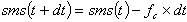
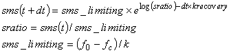
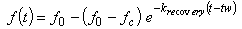
 - the current infiltration rate (m/s)
 on the recovery curve (s)
