The table below displays the list of validation messages that will be displayed in the Output
Window. Click on the message text for further information.
| E0005 |
 RTC definition must not contain spaces RTC definition must not contain spaces
|
Info
|
Network object ID
|
|
Cause
|
The name of an RTC Table or Variable referenced in the RTC definition field of the sections editor for a bank or base linear structure contains spaces.
|
|
Advice
|
Review RTC definition values in sections editor.
|
|

|
| E0006 |
RTC definition for breach must have a measurement type of Depth or Height above datum
|
Info
|
Network object ID
|
|
Cause
|
An RTC Table or Variable has been referenced in the RTC definition field of the sections editor for a bank or base linear structure, but the Output measurement field (for a Table) or Measurement field (for a Variable) of the RTC definition is not set to Depth or Height above datum.
See Modelling Breaches in Banks and Linear Structures.
|
|
Advice
|
Set measurement field of RTC definition to either Depth or Height above datum.
|
|
|
| E0150 |
Bank array has at least one vertex with undefined level
|
Info
|
River Reach / Inline Bank ID
|
|
Cause
|
The section data of a River Reach bank or Inline Bank object has one or more vertices with a missing Bank level value.
|
|
Advice
|
Ensure banks have Bank level values set at all points.
|
|
|
| E2001 |
The network contains no nodes or links or 2D zones
|
Info
|
-
|
|
Cause
|
There are no node or link objects, or 2D zone objects present in the network.
Simulations cannot be run if none of these objects exist.
|
|
Advice
|
Add node, link and/or 2D zone objects to the network.
|
|
|
| E2002 |
Number of 2d elements <number of elements> exceeds the licence limit <licence limit>
|
Info
|
-
|
|
Cause
|
The number of 2D elements in the network exceeds the number of elements that are included in the InfoWorks ICM licence.
|
|
Advice
|
Either reduce the number of 2D elements in the network or increase the element limit included in your licence.
|
|
|
| E2003 |
The number of nodes <number of nodes> exceeds the licence limit <licence limit>
|
Info
|
-
|
|
Cause
|
The number of nodes in the network exceeds the number of nodes that are included in the InfoWorks ICM licence.
|
|
Advice
|
Either reduce the number of nodes in the network or increase the node limit included your licence.
|
|
|
|
E2025
|
Node is not connected to a link
|
Info
|
Node ID
|
|
Cause
|
A node whose Node type is set to Connect 2D is not connected to a link. A Connect 2D node must be connected to a conduit whose Conduit type is set to either Linear Drainage (2D) or Conduit (2D).
|
|
Advice
|
Ensure that the Connect 2D node is connected to a conduit whose type is set to either Linear Drainage (2D) or Conduit (2D). Alternatively, change the Node type setting to another type of node.
|
|

|
|
E2026
|
Manhole floor above manhole roof
|
Info
|
Node ID
|
|
Cause
|
Applicable to nodes whose Type is set to Manhole.
Chamber floor value > Chamber roof value.
|
|
Advice
|
Check the manhole parameters of the reported node.
|
|
|
|
E2026
|
Not in head discharge table
|
Info
|
Node ID
|
|
Cause
|
Applicable to nodes whose Node type is set to Manhole and Flood type is set to Gully or Inlet.
Head discharge table associated with the node has not been defined.
|
|
Advice
|
Define new Head Discharge Table, or select an existing table.
|
|
|
|
E2027
|
Flood depth 2 not above flood depth 1
|
Info
|
Node ID
|
|
Cause
|
Applicable to nodes whose Node type is set to Manhole and whose Flood type is either Storage or Gully where no Storage array has been defined for the gully.
Flood depth 1 value > Flood depth 2 value.
|
|
Advice
|
Check the manhole parameters of the reported node.
|
|
|
|
E2028
|
Not greater than 0.0
|
Info
|
Node ID
|
|
Cause
|
Applicable to nodes of whose Type is set to Storage or Manhole and whose Flood type is set to Gully.
Applicable to rows in the Level/Plan Area Storage Grid except for first and last row:
Plan Area value in the Level / Plan Storage Grid of the node <= 0
|
|
Advice
|
Check Level / Plan Area Storage Grid values.
|
|
|
|
E2033
|
Lowest storage level is below chamber
floor
|
Info
|
Node ID
|
|
Cause
|
Applicable to nodes whose Node type is set to Manhole and Flood type is set to Gully.
The lowest Level value in the Level / Plan Area Storage Grid of the gully node < Chamber floor level.
|
|
Advice
|
Check Level / Plan Area Storage Grid values. Set Relative to Ground option if required.
|
|
|
|
E2034
|
Lowest storage level is above ground
|
Info
|
Node ID
|
|
Cause
|
Applicable to nodes whose Node type is set to Manhole and whose Flood Type is set to Gully.
The lowest Level value in the Level / Plan Area Storage Grid of the gully node > Ground level.
|
|
Advice
|
Check Level / Plan Area Storage Grid values.
|
|
|
|
E2035
|
Vegetation level is above the highest
storage level
|
Info
|
Node ID
|
|
Cause
|
Applicable to nodes whose Node type is set to Pond.
The Vegetation level value is outside of the range defined in the Level / Plan Area / Perimeter Grid of the Pond node.
|
|
Advice
|
Check Level / Plan Area / Perimeter Grid and Vegetation levels.
|
|
|
|
E2036
|
Vegetation level is below the lowest
storage level
|
Info
|
Node ID
|
|
Cause
|
Applicable to nodes whose Node type is set to Pond.
The Vegetation level value is outside of the range defined in the Level / Plan Area / Perimeter Grid of the Pond node.
|
|
Advice
|
Check Level / Plan Area / Perimeter Grid and Vegetation levels.
|
|
|
|
E2037
|
Liner level is below the lowest storage
level
|
Info
|
Node ID
|
|
Cause
|
Applicable to nodes whose Type is set to Pond.
The Liner level value is outside of the range defined in the Level / Plan Area / Perimeter Grid of the Pond node.
|
|
Advice
|
Check Level / Plan Area / Perimeter Grid and Liner levels.
|
|
|
|
E2038
|
Vegetation level is below liner level
|
Info
|
Node ID
|
|
Cause
|
Applicable to nodes whose Node type is set to Pond.
The Vegetation level value is below the Liner level of the Pond node.
|
|
Advice
|
Check Vegetation and Liner levels.
|
|
|
|
E2039
|
Highest pond storage level is above ground
|
Info
|
Node ID
|
|
Cause
|
Applicable to nodes whose Node type is set to Pond.
The highest Level value in the Level / Plan Area / Perimeter Grid > Ground level value of the Pond node.
|
|
Advice
|
Check pond level values and ground level value.
|
|
|
|
E2040
|
More than one subcatchment drains to this
pond
|
Info
|
Node ID
|
|
Cause
|
Applicable to nodes whose Node type is set Pond.
The pond node is the associated node ID for more than one subcatchment.
|
|
Advice
|
Check subcatchments are associated with the correct nodes.
|
|
|
|
E2046
|
No more than two overland links may be connected to this node
|
Info
|
Node ID
|
|
Cause
|
Applicable to nodes whose Node type is set to Manhole and Flood type is set to Inlet.
There are more than two links of System type set to Overland connected to the node identified.
|
|
Advice
|
Check connectivity of inlet node.
|
|
|
|
E2047
|
One or more overland links must be attached to this inlet node
|
Info
|
Node ID
|
|
Cause
|
Applicable to nodes whose Node type is set to Manhole and Flood type is set to Inlet for continuous and flow-efficiency inlets.
There are no links of System type set to Overland connected to the node identified.
|
|
Advice
|
Check connectivity of inlet node.
|
|
|
|
E2048
|
The highest storage level on an inlet cannot be equal to ground level
|
Info
|
Node ID
|
|
Cause
|
Applicable to nodes whose Node type is set to Manhole and whose Flood type is set to Inlet.
The highest Level value in the Storage Level / Plan Area grid is equal to the Ground Level value.
This is not allowed for inlet nodes, as storage type is assumed to be Lost in this case.
|
|
Advice
|
Add an extra Level entry in the Storage Level / Plan Area grid that is 1 mm above ground level.
|
|
|
|
E2050
|
Unconnected to outfall
|
Info
|
Conduit / Ancillary ID
|
|
Cause
|
The branch of the network that the link is connected in to does not lead to an Outfall Node.
|
|
Advice
|
Check the connectivity of the branch of the network containing the reported link.
|
|
|
|
E2051
|
Below attached node's lowest storage
level
|
Info
|
Conduit ID
|
|
Cause
|
Applicable to conduits linked to Nodes of type Storage.
Upstream/Downstream Invert Level of downstream/upstream link < lowest level in connected Storage Node Level / Plan Area grid.
|
|
Advice
|
Check invert levels of connected links and Storage Node Level values.
|
|
|
|
E2051
|
Not in flow efficiency table
|
Info
|
Node ID
|
|
Cause
|
Applicable to nodes whose node type is set to Manhole and whose Flood type is set to Inlet.
The Flow Efficiency Table associated with node has not been defined.
|
|
Advice
|
Define new Flow Efficiency Table, or select an existing table.
|
|
|
|
E2052
|
Below attached node's chamber floor level
|
Info
|
Node ID
|
|
Cause
|
Applicable to conduits linked to Nodes of type Manhole.
US/DS Invert level of conduit < Chamber floor level of connected node.
|
|
Advice
|
Check invert levels of connected links and Node levels.
|
|
|
|
E2053
|
This field must be expressed as a percentage
|
Info
|
Node ID
|
|
Cause
|
Applicable to nodes of whose Node type is set to Manhole and whose Flood type is set to Inlet.
% Clogging value is less than 0 or greater than 100.
|
|
Advice
|
Redefine % Clogging value as a percentage.
|
|
|
|
E2060
|
Less than width/2
|
Info
|
Conduit ID
|
|
Cause
|
Applicable to conduits whose Shape ID is set to UTOP, OU, ARCH, OEGB and CNET.
Cross Section Height (m) < 0.5 x Width (m).
|
|
Advice
|
Check Cross Section parameters of reported conduit.
|
|
|
|
E2061
|
Less than width
|
Info
|
Conduit ID
|
|
Cause
|
Applicable to conduits whose Shape ID is set to OVAL.
Cross Section Height (m) < Width (m).
|
|
Advice
|
Check Cross Section parameters of reported conduit
|
|
|
|
E2062
|
Less than width
|
Info
|
Conduit ID
|
|
Cause
|
Applicable to conduits whose Shape ID is set to EGG.
Cross Section Height (m) < Width (m).
|
|
Advice
|
Check Cross Section parameters of reported conduit.
|
|
|
|
E2063
|
Less than height/2
|
Info
|
Conduit ID
|
|
Cause
|
Applicable to conduits whose Shape ID is set to EGG.
Cross Section Width (m) < 0.5 x Height (m).
|
|
Advice
|
Check Cross Section parameters of reported conduit
|
|
|
|
E2064
|
Less than width
|
Info
|
Conduit ID
|
|
Cause
|
Applicable to conduits whose Shape ID is set to EGG2.
Cross Section Height (m) < Width (m).
|
|
Advice
|
Check Cross Section parameters of reported conduit.
|
|
|
|
E2065
|
Less than (height-width)/2
|
Info
|
Conduit ID
|
|
Cause
|
Applicable to conduits whose Shape ID is set to EGG2.
Cross Section Width < 0.5 x (Height - Width).
Where Height and Width are in m.
|
|
Advice
|
Check Cross Section parameters of reported conduit.
|
|
|
|
E2066
|
Less than width
|
Info
|
Conduit ID
|
|
Cause
|
Applicable to conduits whose Shape ID is set to OEGN.
Cross Section Height (m) < 0.5 x Width (m).
|
|
Advice
|
Check Cross Section parameters of reported conduit.
|
|
|
|
E2067
|
Less than (height-width/2)/2
|
Info
|
Conduit ID
|
|
Cause
|
Applicable to conduits whose Shape ID is set to OEGN.
0.5 x Width < Height - (0.5 x Width).
Where Height and Width are in m.
|
|
Advice
|
Check Cross Section parameters of reported conduit.
|
|
|
|
E2069
|
Less than height-(width/2)
|
Info
|
Conduit ID
|
|
Cause
|
Applicable to conduits whose Shape ID is set to CNET.
0.5 x Width < Height - (0.5 x Width)
Where Height and Width are in m.
|
|
Advice
|
Check Cross Section parameters of reported conduit.
|
|
|
|
E2070
|
Not in shape set
|
Info
|
Conduit ID
|
|
Cause
|
The shape specified in the Shape ID field of the conduit does not exist.
|
|
Advice
|
Define new Shape or select existing Shape.
|
|
|
|
E2072
|
Less than height - width/2
|
Info
|
Conduit ID
|
|
Cause
|
Applicable to conduits whose Shape ID is set to OEGB.
Width < Height - (0.5 x Width)
Where Height and Width are in m.
|
|
Advice
|
Check Cross Section parameters of reported conduit.
|
|
|
|
E2072
|
Fill Material Conductivity is required for
modelling Permeable Media solution-type conduits
|
Info
|
Conduit ID
|
|
Cause
|
Applicable to conduits whose Solution model is set to Permeable.
Fill material conductivity has not been defined.
|
|
Advice
|
Enter a value in the Fill material conductivity field.
|
|
|
|
E2073
|
The base flow depth exceeds the conduit
height. Check simulation parameters
|
Info
|
Conduit ID
|
|
Cause
|
|
Sediment Depth + minimum base flow depth >= Conduit Height
|
1
|
Where minimum base flow depth is the greater of:
|
(conduit height - sediment depth) x Base Flow Factor
Where:
Base Flow Factor is defined in Simulation Parameters
If Gradient > Slope Where Base Flow is Doubled (defined in Simulation Parameters), minimum base flow depth = Equation 2 x 2
|
2
|
and
|
Minimum Base Flow Depth (defined in Simulation Parameters)
|
3
|
|
|
Advice
|
Check Simulation Parameters are as expected.
|
|
|
|
E2073
|
Porosity is required for modelling
Permeable Media solution-type conduits
|
Info
|
Conduit ID
|
|
Cause
|
Applicable to conduits whose Solution model is set to Permeable.
Porosity has not been defined.
|
|
Advice
|
Enter a value in the Porosity field.
|
|
|
|
E2074
|
Hazen-Williams roughness can only be
used on ForceMain pipes
|
Info
|
Conduit ID
|
|
Cause
|
Roughness Type field of conduit is set to HW, but Solution model field is not set to ForceMain.
|
|
Advice
|
Check Solution model and Roughness type fields are as expected.
|
|
|
|
E2075
|
Normal or high headlosses are not allowed
for ForceMain Solution types
|
Info
|
Conduit ID
|
|
Cause
|
Solution Model field of conduit is set to ForceMain and Downstream headloss type or Upstream headloss type field is set to NORMAL or HIGH.
Headloss type must be set to FIXED or NONE when using the ForceMain solution model.
|
|
Advice
|
Check Solution Model and Headloss Type fields are as expected.
|
|
|
|
E2076
|
Below attached node's lowest storage level
|
Info
|
Flap Valve ID
|
|
Cause
|
Applicable to Flap Valves linked to Nodes of type Storage.
Upstream/Downstream Invert Level of downstream/upstream link < lowest level in connected Storage Node Level / Plan Area grid.
|
|
Advice
|
Check invert levels of connected links and Storage Node Level values.
|
|
|
|
E2076
|
Roughness value must be greater than zero
|
Info
|
Conduit ID
|
|
Cause
|
Top or Bottom Roughness value of conduit identified is less than zero.
|
|
Advice
|
Set roughness of conduit to value greater than zero.
|
|
|
|
E2077
|
Below attached node's chamber floor
|
Info
|
Flap Valve ID
|
|
Cause
|
Applicable to Flap Valve objects linked to Nodes of type Manhole.
Invert Level of Flap Valve < Chamber Floor Level of connected node
|
|
Advice
|
Check invert levels of connected links and Node Levels.
|
|
|
|
E2077
|
Springing height must be less than height
|
Info
|
Conduit ID
|
|
Cause
|
Conduit Shape ID is set to SPRUNGARCH and conduit Springing height is greater than conduit Height.
|
|
Advice
|
Check Springing height of conduit.
|
|
|
|
E2078
|
This 2D manhole/2D outfall is not contained within a
2D zone
|
Info
|
Node ID
|
|
Cause
|
2D node is not within a 2D Zone.
2D nodes are:
- Nodes whose Node type is set to Manhole and Flood type is set to 2D or Gully 2D
- Nodes whose Node typeis set to Outfall 2D
|
|
Advice
|
Add a 2D Zone that includes the 2D node within its boundary.
|
|
|
|
E2078
|
Height of arch above springing must be less than half of width
|
Info
|
Conduit ID
|
|
Cause
|
Conduit Shape ID is set to SPRUNGARCH and conduit Height - Springing height is greater than conduit Width/2.
|
|
Advice
|
Check Springing height of conduit.
|
|
|
|
E2079
|
This 2D manhole/2D outfall is not contained within a
2D zone mesh element
|
Info
|
Node ID
|
|
Cause
|
A 2D node is within a 2D Zone, but not within a mesh element.
2D nodes are:
- Nodes whose Node type is set to Manhole and Flood type is set to 2D or Gully 2D
- Nodes whose Node type is set to Outfall 2D
|
|
Advice
|
The 2D node may be within a void in the 2D mesh.
Check that the node location is as expected.
Check that the objects or file used to define voids are as expected.
|
|
|
|
E2080
|
FHWA is only valid as a US/DS headloss type if the US/DS node is a manhole
FHWA is only valid as a US or DS headloss type if the conduit is closed
FHWA is only valid if the solution model of the conduit is FULL
|
Info
|
Conduit ID
|
|
Cause
|
US/DS headloss type has been set to FHWA but the headloss type is not valid in the following conditions:
- connected node has Node type set to type other than Manhole
- conduit has Shape ID that defines an open pipe
- conduit has Solution model set to type other than Full
|
|
Advice
|
Select a suitable headloss type for the conduit.
|
|
|
|
E2082
|
2D node with Chamber floor level >= Ground level
|
Info
|
Node ID
|
|
Cause
|
The node has Flood type of Gully 2D or 2D and the value in the Chamber floor level field is greater than or equal to the value in the Ground level field.
This can cause simulation convergence problems if the level in the 2D zone in which the node is located is lower than the node's chamber floor.
|
|
Advice
|
Check the level parameters of the node.
|
|
|
| E2083 |
The minimum area including voids (Ag) is outside of the accepted range of 0 >= Ag <= W x L
|
Info
|
Node ID
|
|
Cause
|
The node has Inlet type of UPC Grate and the value in the Minimum area including voids field is greater than or equal to zero, or less than or equal to Grate width x Grate length. |
|
Advice
|
Review the Inlet parameter field values. |
|
|
| E2084 |
The area of voids (Ah) is greater than the minimum area including voids (Ag)
|
Info
|
Node ID
|
|
Cause
|
The node has Inlet type of UPC Grate and the value in the Area of voids field is greater than the value in the Minimum area including voids field. |
|
Advice
|
Review the Inlet parameter field values. |
|
|
| E2086 |
A value must be specified for this field when conduit headloss is FHWA
|
Info
|
Node ID
|
|
Cause
|
The Benching method field for the node has not been set and the conduit end that the node is connected to has headloss type set to FHWA.
|
|
Advice
|
Select a Benching method value for the node. |
|
|
|
E2087
|
Flood type is lost; chamber floor height should not be greater than ground level
|
Info
|
Node ID
|
|
Cause
|
The node has Flood type of Lost and the value in the Chamber floor level field is greater than the value in the Ground level field.
|
|
Advice
|
Check the level parameters of the node.
|
|
|
|
E2088
|
The weir behaviour depth is less than or equal to the curb opening height of <opening height value>
|
Info
|
Node ID
|
|
Cause
|
Applicable to nodes with Flood type of Inlet or Inlet 2D and Inlet type of SagC or SagCO.
The Weir behaviour depth field is not greater than the value in the Opening height field.
|
|
Advice
|
Set the Weir behaviour depth to a value greater than the Opening height.
|
|
|
|
E2089
|
Node of type 'Connect 2D' and connection type '2D' must be inside a 2D zone's boundary
|
Info
|
Node
|
|
Cause
|
A Connect 2D type of node with a connection type of 2D is not located within a 2D zone.
|
|
Advice
|
Either move the node so that it is located within a 2D zone or change the type of node in the Node type field or the type of connection in the Connection type field.
|
|
|
|
E2090
|
Node of type 'Connect 2D' and connection type 'Break' must be connected to exactly 2 conduits of type 'Conduit 2D' or 'Linear Drainage 2D'
|
Info
|
Node
|
|
Cause
|
A Break type of Connect 2D node is not currently connected to two conduits which are of the type Conduit (2D) or Linear Drainage (2D).
|
|
Advice
|
Ensure that the Connect 2D node of type Break is connected to two conduits (one at either end) of the type Conduit (2D) or Linear Drainage (2D), or change the type of connection node in the Connection type field, or the type of conduit in the Conduit type field.
|
|
|
|
E2091
|
Node of type 'Connect 2D' can only be connected to conduits of type 'Conduit 2D' or 'Linear Drainage 2D'
|
Info
|
Node (Connectivity)
|
|
Cause
|
A Connect 2D node is not currently connected to a conduit which is of the type Conduit (2D) or Linear Drainage (2D).
|
|
Advice
|
Ensure that the Connect 2D node is connected to a conduit of the type Conduit (2D) or Linear Drainage (2D), or change the type of connection node in the Connection type field, or the type of conduit in the Conduit type field.
|
|
|
|
E2092
|
Linked by 2D conduits(s) to node <node id> which is connected to a different 2D zone
|
Info
|
Node ID
|
|
Cause
|
Either a single conduit of type Conduit (2D) or Linear Drainage (2D), or a chain of them, is connected (at either end) to 2 different Connect 2D nodes of connection type 2D, which are located in different 2D zones.
Note that this message is displayed for each node at either end of the conduit or chain of conduits.
|
|
Advice
|
A single Conduit (2D) or Linear Drainage (2D) type of conduit or a chain must be connected to nodes that are located in the same 2D zone. Therefore, move the applicable nodes so that they are located within the same 2D zone.
|
|
|
|
E2093
|
Linked by 2D conduits(s) to conduit <conduit id> which is connected to a different 2D zone
|
Info
|
Node
|
|
Cause
|
Two or more conduits of the type Linear Drainage (2D), which are connected to Connect 2D nodes with the connection type 2D, are located in different 2D zones.
|
|
Advice
|
Move the conduit(s), and any associated Connect 2D nodes of the type 2D, if applicable, so that they are located within the same 2D zone.
|
|
|
|
E2094
|
Must be either CIRC or RECT for conduit types 'Conduit (2D)' or 'Linear Drainage (2D)'
|
Info
|
Conduit
|
|
Cause
|
The Shape ID field is not set to either CIRC or RECT. Conduits with their Conduit type set to Conduit 2D or Linear Drainage 2D must have a Shape ID set to either CIRC or RECT.
|
|
Advice
|
Either change the Shape ID field to either CIRC or RECT, or change the Conduit type field to Conduit.
|
|
|
|
E2095
|
Must be N (Manning's n) for conduit types 'Conduit (2D)' or 'Linear Drainage (2D)'
|
Info
|
Conduit (Top/Bottom roughness)
|
|
Cause
|
The Roughness type field is not set to N (Manning's n). Conduits with their Conduit type set to Conduit 2D or Linear Drainage 2D must have the Roughness type field is set to N (Manning's n).
|
|
Advice
|
Either change the Roughness type field to N (Manning's n) or change the Conduit type field to Conduit.
|
|
|
|
E2096
|
Top and bottom roughness be Manning's n values must be the equal for conduit types 'Conduit (2D)' or 'Linear Drainage (2D)'
|
Info
|
Conduit (Roughness type)
|
|
Cause
|
The Roughness type field is set to N (Manning's n) and the Conduit type is set to either Conduit 2D or Linear Drainage 2D. But the different values have been specified for the Top roughness and Bottom roughness fields; these should be the same.
|
|
Advice
|
Either specify the same value for the Top roughness and Bottom roughness fields, or change the Conduit type field to Conduit.
|
|
|
|
E2097
|
Slot width must not exceed conduit width
|
Info
|
Conduit
|
|
Cause
|
The specified width for the slot is greater than the width specified for the conduit.
|
|
Advice
|
Either change the value specified in the Slot width field so that it is smaller than width for the conduit (specified in the Width field), or increase the value in the conduit Width field.
|
|
|
|
E2098
|
Conduit of type 'Linear drainage (2D)' must be fully inside a single 2D zone's boundary
|
Info
|
Conduit ID
|
|
Cause
|
One or more conduits of type of Linear drainage (2D) are not located with the same 2D zone.
|
|
Advice
|
Ensure that a single Linear drainage (2D) type of conduit, or all the conduits which comprise a chain of them, are located within the same 2D zone boundary. Move the applicable conduit(s) if necessary.
|
|
|
|
E2099
|
Conduit of type '<conduit type>' must be connected to at least one node of type 'Connect 2D'
|
Info
|
Conduit ID
|
|
Cause
|
A conduit of type Linear drainage (2D) or Conduit 2D is not connected to a node of type Connect 2D but it must be connected to at least one node of that type.
|
|
Advice
|
Ensure that the node selected in the conduit's US Node ID or DS Node ID field is a Connect 2D type of node.
|
|
|
|
E2100
|
Linked by 2D conduits(s) to conduit <conduit id> which is connected to a different 2D zone
|
Info
|
Conduit ID
|
|
Cause
|
Two or more conduits of the type Linear Drainage (2D) are located in different 2D zones.
|
|
Advice
|
Move the conduit(s), and any associated Connect 2D nodes of the type 2D if applicable, so that they are located within the same 2D zone.
|
|
|
|
E2101
|
Less than minimum flow
|
Info
|
Orifice ID
|
|
Cause
|
Applicable to VLDorf link types.
Maximum flow < Minimum Flow.
|
|
Advice
|
Check the Regulator parameters of the reported VLDorf object.
|
|
|
|
E2101
|
Below attached node's lowest storage level
|
Info
|
Orifice ID
|
|
Cause
|
Applicable to Orifice objects linked to Nodes of type Storage.
Invert Level of orifice < lowest level in connected Storage Node Level / Plan Area grid.
|
|
Advice
|
Check invert levels of orifice and Storage Node Level values.
|
|
|
|
E2102
|
Below attached node's chamber floor
|
Info
|
Orifice ID
|
|
Cause
|
Applicable to Orifice objects linked to Nodes of type Manhole.
Invert Level of Orifice < Chamber Floor Level of connected node.
|
|
Advice
|
Check invert levels of connected links and Node Levels.
|
|
|
|
E2103
|
No Bridge inlet/outlet exists with ID <inlet/outlet ID>
|
Info
|
Bridge Opening ID
|
|
Cause
|
An ID has been entered in the Inlet ID / Outlet ID field of the bridge opening, but a bridge inlet/outlet of that name does not exist in the network.
|
|
Advice
|
Review Inlet ID / Outlet ID values.
|
|
|
|
E2104
|
Cannot specify both an Inlet ID and an Inlet Blockage ID
|
Info
|
Bridge Opening - Inlet ID
|
|
Cause
|
An ID has been specified for the Inlet ID and Inlet Blockage ID fields of the bridge opening, but you can only specify one or the other; not both at the same time.
|
|
Advice
|
Select an Inlet ID or an Inlet Blockage ID.
|
|
|
|
E2105
|
Not linked to either Connect 2D node of connection type '2D' or, via a chain of conduits, to a conduit of type 'Linear Drainage (2D)'
|
Info
|
Conduit
|
|
Cause
|
A conduit of type Conduit (2D) is not currently connected to either a Connect 2D node of connection type 2D, or via a chain of conduits to a conduit type of Linear Drainage (2D).
|
|
Advice
|
Check the connections for this conduit or change it's Connection type.
|
|
|
|
E2106
|
The Min space step field cannot exceed the Max space step field defined for the network’s simulation parameters
|
Info
|
Conduit
|
|
Cause
|
The Max space step field specified for this network's simulation parameters is smaller than the Min space step defined for this Conduit 2D type of conduit.
|
|
Advice
|
Change the Min space step for the conduit so that it is smaller than the Max space step set in the simulation parameters. Alternatively, increase the Max space step set in the simulation parameters but this may affect the results for other objects in the network when a simulation is run.
|
|
|
|
E2107
|
Linked by 2D conduits(s) to node <node id> which is connected to a different 2D zone
|
Info
|
Conduit
|
|
Cause
|
Two or more conduits of the type Linear Drainage (2D) are connected to Connect 2D nodes of type 2D which are located in different 2D zones.
|
|
Advice
|
Move the Connect 2D nodes of the type 2D, and any associated Linear Drainage (2D) conduits, if applicable, so that they are located within the same 2D zone.
|
|
|
|
E2108
|
Not linked to a Connect 2D node of connection type '2D'
|
Info
|
Conduit
|
|
Cause
|
A single conduit of type Conduit (2D) is not currently connected to a Connect 2D node of connection type 2D.
|
|
Advice
|
If the conduit is connected to a Connect 2D node then ensure that the Connection type for the node is set to 2D. Otherwise, set the Node type to Connect 2D node and the Connection type to 2D.
|
|
|
|
E2126
|
Not in head discharge table
|
Info
|
Pump ID
|
|
Cause
|
Applicable to pumps of Link type ScrPmp and RotPmp.
Head Discharge object selected in the Head Discharge Table field of the Pump object has not been defined.
|
|
Advice
|
Define new Head Discharge Table or select an existing table.
|
|
|
|
E2126
|
Minimum speed > Nominal Speed > Maximum Speed
|
Info
|
Pump ID
|
|
Cause
|
Applicable to pumps of Link type VfdPmp
This error message may be displayed for the following reasons:
- Minimum Speed is greater than Maximum Speed
- Nominal Speed is less than Minimum Speed
- Nominal Speed is greater than Maximum Speed
Where:
Nominal Speed is defined in the Head Discharge table accessed from the Pump Definition page of the Pump property sheet.
Minimum Speed and Maximum Speed are defined on the Regulator page of the Pump property sheet.
|
|
Advice
|
Review speed values for the pump.
|
|
|
|
E2127
|
Less than minimum flow
|
Info
|
Pump ID
|
|
Cause
|
Applicable to VspPmp link types.
Maximum flow < Minimum Flow.
|
|
Advice
|
Check the Regulator parameters of the reported VspPmp object.
|
|
|
|
E2127
|
Springing height must be less than height
|
Info
|
Bridge Opening ID
|
|
Cause
|
Bridge Opening Shape ID is set to SPRUNGARCH and opening Springing height is greater than opening Height.
|
|
Advice
|
Check Springing height of opening
|
|
|
|
E2128
|
Less than switch off level
|
Info
|
Pump ID
|
|
Cause
|
Switch on level < Switch off level.
|
|
Advice
|
Check the Pump Definition fields of the reported Pump object.
|
|
|
|
E2128
|
Height of arch above springing must be less than half of width
|
Info
|
Bridge Opening ID
|
|
Cause
|
Bridge Opening Shape ID is set to SPRUNGARCH and opening Height - Springing height is greater than opening Width/2.
|
|
Advice
|
Check Springing height of opening.
|
|
|
|
E2151
|
Less than minimum opening
|
Info
|
Sluice ID
|
|
Cause
|
Applicable to VSGate objects.
Regulator parameter Maximum Opening < Minimum Opening.
|
|
Advice
|
Check the Regulator Parameters fields of the VSGate object.
|
|
|
|
E2151
|
Below attached node's lowest storage level
|
Info
|
Sluice ID
|
|
Cause
|
Applicable to Sluice objects linked to Nodes of type Storage.
Invert Level of Sluice < lowest level in connected Storage Node Level / Plan Area grid.
|
|
Advice
|
Check Sluice invert level and Storage Node Level values.
|
|
|
|
E2152
|
Below attached node's chamber floor
|
Info
|
Sluice ID
|
|
Cause
|
Applicable to Sluice objects linked to Nodes of type Manhole.
Invert Level of Sluice < Chamber Floor Level of connected node
|
|
Advice
|
Check invert levels of connected links and Node Levels.
|
|
|
| E2153 |
Must be greater than Depth threshold 1
|
Info
|
Roughness definition
|
|
Cause
|
The value specified for Depth threshold 2 is less than the value specified for Depth threshold 1 but it must be greater.
|
|
Advice
|
Check the Depth threshold 1 and Depth threshold 2 values for the relevant Roughness definition object, and ensure that the value specified for Depth threshold 2 is greater than the value specified for Depth threshold 1.
|
|
|
|
E2176
|
Not in head discharge table
|
Info
|
User Control ID
|
|
Cause
|
Head Discharge object selected in the Head Discharge Table field of the User Control object has not been defined.
|
|
Advice
|
Define new Head Discharge Table or select an existing table.
|
|
|
|
E2176
|
Below attached node's lowest storage level
|
Info
|
User Control ID
|
|
Cause
|
Applicable to User Control objects linked to Nodes of type Storage.
Invert Level of User Control < lowest level in connected Storage Node Level / Plan Area grid.
|
|
Advice
|
Check invert levels of connected links and Storage Node Level values.
|
|
|
|
E2177
|
Below attached node's chamber floor
|
Info
|
User Control ID
|
|
Cause
|
Applicable to User Control objects linked to Nodes of type Manhole.
Invert Level of User Control < Chamber Floor Level of connected node.
|
|
Advice
|
Check invert levels of connected links and Node Levels.
|
|
|
| E2177 |
TVD connector specified for input does not exist
|
Info
|
TVD Connector ID
|
|
Cause
|
The TVD connector specified in one of the Input fields does not exist in the network.
|
|
Advice
|
Review the TVD ID entered in the Input field.
If the ID refers to a TSDB data stream, prefix the ID with a '#'.
|
|
|
|
E2180
|
Connected object not found in network
|
Info
|
TVD Connector ID
|
|
Cause
|
Applicable to TVD Connectors.
Displayed if the Connected object id does not correspond with the ID of a network object of type specified in the Connected object type field.
Displayed if Connected object type is set to hw_rtc and the specified Connected object id does not correspond to an RTC table ID. (When referencing RTC tables, the reference should take the form RegulatorID.TableName for tables defined in regulators in the RTC, or TableName for tables defined in the Global section of the RTC.)
|
|
Advice
|
Review the Connected object type and Connected object id fields.
|
|
|
| E2182 |
Input attribute is invalid or has wrong units
|
Info
|
TVD Connector ID
|
|
Cause
|
The Connection usage field is set to Input and the value in the Input attribute field does not have the same units as the Output units type specified.
|
|
Advice
|
Review the Input attribute and Output units type fields.
|
|
|
| E2183 |
Result attribute is invalid or has wrong units
|
Info
|
TVD Connector ID
|
|
Cause
|
The Connection usage field is set to Comparison and the value in the Comparison result field does not have the same units as the Output units type specified. |
|
Advice
|
Review the Comparison result and Output units type fields. |
|
|
| E2183 |
Object type and result type attribute not allowed for ARAM output
|
Info
|
TVD Connector ID
|
|
Cause
|
The selected Connected object type and the selected Comparison result are not a valid combination for ARMA post-processing. |
|
Advice
|
Review the selection of the Connected object type and the Comparison result fields. The permitted combinations are listed in the TVD Connector Data Fields topic. |
|
|
| E2184 |
TVD connectors require at least one input
|
Info
|
TVD Connector ID
|
|
Cause
|
There are no values defined in any of the input fields.
|
|
Advice
|
Specify an Input (either TVD connector ID or data stream).
|
|
|
| E2187 |
There can be at most one TVD connector with output units of evaporation or temperature
|
Info
|
TVD Connector ID
|
|
Cause
|
More than one TVD connector has Output units type set to EV -evaporation or CF - temperature.
|
|
Advice
|
Currently only one evaporation or temperature profile can be applied to the network using TVD connectors.
|
|
|
| E2188 |
Invalid connector unit for output unit type
|
Info
|
TVD Connector ID
|
|
Cause
|
The type of unit selected in the Connector units field cannot be used with the unit type selected in the Output unit type field.
|
|
Advice
|
Change the item currently selected in either the Connector units or the Output unit type field.
|
|
|
| E2190 |
ARMA model not defined
|
Info
|
ARMA ID
|
|
Cause
|
The name of the specified ARMA model either does not exist or is not fully defined.
|
|
Advice
|
Check that all the data fields for the ARMA model have been specified. Note that the Autoregressive and Moving average parameters can only be specified via the ARMA Property Sheet.
|
|
|
|
E2199
|
Must be FHWA. US/DS node <node id> is DS/US node of conduit <conduit id> which has DS/US headloss type FHWA
|
Info
|
Node ID, Conduit ID
|
|
Cause
|
The end of a conduit with headloss type that is not FHWA is connected to the end of another conduit with headloss type FHWA.
If one conduit has headloss type FHWA at an end connected to a manhole, all the pipes connected to that manhole must have FHWA headloss at the end connected to the manhole.
|
|
Advice
|
Review the headloss type fields of connected pipes.
|
|
|
|
E2201
|
Less than minimum value
|
Info
|
Weir ID
|
|
Cause
|
Applicable to VCWeir and VWWeir objects.
Regulator parameter Maximum Value < Minimum Value.
|
|
Advice
|
Check the Regulator Parameters fields of the Weir object.
|
|
|
|
E2202
|
The total weir width is insufficient
to accommodate the notch(es)
|
Info
|
Weir ID
|
|
Cause
|
Applicable to TRWeir objects.
Notch Width x Number of Notches < Width.
|
|
Advice
|
Check the Weir Definition fields of the TRWeir object.
|
|
|
|
E2202
|
Below attached node's chamber floor
|
Info
|
Weir ID
|
|
Cause
|
Applicable to Weir objects linked to Nodes of type Manhole.
Invert Level of Weir < Chamber Floor Level of connected node.
|
|
Advice
|
Check invert levels of connected links and Node Levels.
|
|
|
|
E2203
|
The notch width is too narrow
|
Info
|
Weir ID
|
|
Cause
|
Applicable to TRWeir objects.
Notch Width < 0.5 x Notch Height.
|
|
Advice
|
Check the Weir Definition fields of the TRWeir object.
|
|
|
|
E2204
|
The total weir width is insufficient
to accommodate the notch(es)
|
Info
|
Weir ID
|
|
Cause
|
Applicable to VNWeir objects.
Notch Height x 2 x tan(Notch Angle/2) x No. of Notches > Weir Width.
|
|
Advice
|
Check the Weir Definition fields of the VNWeir object.
|
|
|
|
E2205
|
Boundary of 2D zone has changed since
meshing was performed
|
Info
|
2D Zone ID
|
|
Cause
|
The 2D Zone boundary was edited after the current 2D mesh was created.
|
|
Advice
|
Re-mesh the 2D Zone using the current polygon boundary.
|
|
|
|
E2206
|
Maximum triangle area has changed since
meshing was performed
|
Info
|
2D Zone ID
|
|
Cause
|
The value in the Maximum Triangle Area field of the 2D Zone is different to the area value used to create the current mesh.
|
|
Advice
|
Either reset the Maximum Triangle Area of the 2D Zone to the value used when the current mesh was created, or re-mesh the 2D Zone using the current Maximum Triangle Area value.
|
|
|
|
E2207
|
Minimum angle has changed since meshing
was performed
|
Info
|
2D Zone ID
|
|
Cause
|
The value in the Minimum Angle field of the 2D Zone is different to the minimum angle value used to create the current mesh.
|
|
Advice
|
Either reset the Minimum Angle of the 2D Zone to the value used when the current mesh was created, or re-mesh the 2D Zone using the current Minimum Angle value.
|
|
|
|
E2208
|
Mesh zone <mesh zone id> has been
deleted/renamed since meshing was performed
|
Info
|
2D Zone ID, Mesh Zone ID
|
|
Cause
|
The Mesh Zone identified was used to create the current mesh in the 2D Zone, but no longer exists.
This error may be caused as a result of renaming of the Mesh Zone.
|
|
Advice
|
Re-mesh the 2D Zone using the current set of mesh zones.
Alternatively, if the Mesh Zone was renamed, reset the Mesh Zone ID to the value used when the 2D mesh was created.
|
|
|
|
E2209
|
Mesh zone <mesh zone id> has had its
maximum triangle area changed since meshing was performed
|
Info
|
2D Zone ID, Mesh Zone ID
|
|
Cause
|
The value in the Maximum Triangle Area field of the Mesh Zone is different to the area used when creating the current mesh in the 2D Zone.
|
|
Advice
|
Either reset the Maximum Triangle Area of the Mesh Zone to the value used when the 2D mesh was created, or re-mesh the 2D Zone using the current Mesh Zone Maximum Triangle Area value.
|
|
|
|
E2210
|
Mesh zone <mesh zone id> has had its
boundary changed since meshing was performed
|
Info
|
2D Zone ID, Mesh Zone ID
|
|
Cause
|
The boundary of a Mesh Zone used to create the 2D Zone mesh was edited after the 2D mesh was created.
|
|
Advice
|
Re-mesh the 2D Zone using the current Mesh Zone boundary.
|
|
|
|
E2211
|
Roughness zone <roughness zone id>
has been deleted/renamed since meshing was performed
|
Info
|
2D Zone ID, Roughness Zone ID
|
|
Cause
|
The Roughness Zone identified was used to create the current mesh in the 2D Zone, but no longer exists.
This error may be caused as a result of renaming of the Roughness Zone.
|
|
Advice
|
Re-mesh the 2D Zone using the current set of Roughness Zones.
Alternatively, if the Roughness Zone was renamed, reset the Roughness Zone ID to the value used when the 2D mesh was created.
|
|
|
|
E2212
|
Roughness zone <roughness zone id>
has had its boundary changed since meshing was performed
|
Info
|
2D Zone ID, Roughness Zone ID
|
|
Cause
|
The boundary of a Roughness Zone used to create the 2D Zone mesh was edited after the 2D mesh was created.
|
|
Advice
|
Re-mesh the 2D Zone using the current Roughness Zone boundary.
|
|
|
|
E2213
|
Polygons belonging to voids category
<category id> have changed since meshing was performed
|
Info
|
2D Zone ID, Polygon Category ID
|
|
Cause
|
The boundary of a Polygon object(s) belonging to the Polygons Category used to identify voids at the time of creating the current 2D mesh, was edited after the mesh was created.
This includes edits to polygons in the voids category that do not intersect the 2D Zone.
(Where voids have been derived from a file or layer, changes to the file or layer are not validated.)
|
|
Advice
|
Re-mesh the 2D Zone using the current Polygon set.
|
|
|
|
E2214
|
Lines belonging to break lines category
<category id> have changed since meshing was performed
|
Info
|
2D Zone ID, Line Category ID
|
|
Cause
|
The geometry of a Line(s) belonging to the Line Category used to identify Break Lines at the time of creating the current 2D mesh, was edited after the mesh was created.
This includes edits to Lines in the Break Lines category that do not intersect the 2D Zone.
(Where Break Lines have been derived from a file or layer, changes to the file or layer are not validated.)
|
|
Advice
|
Re-mesh the 2D Zone using the current Line set.
|
|
|
|
E2215
|
Lines belonging to walls category
<category id> have changed since meshing was performed
|
Info
|
2D Zone ID, Line Category ID
|
|
Cause
|
The geometry of a Line(s) belonging to the Line Category used to identify Walls at the time of creating the current 2D mesh, was edited after the mesh was created.
This includes edits to Lines in the Walls category that do not intersect the 2D Zone.
(Where Walls have been derived from a file or layer, changes to the file or layer are not validated.)
|
|
Advice
|
Re-mesh the 2D Zone using the current Line set.
|
|
|
|
E2216
|
Mesh zone <mesh zone id> has been
added since meshing was performed
|
Info
|
2D Zone ID, Mesh Zone ID
|
|
Cause
|
The Mesh Zone identified has a Maximum Triangle Area defined and intersects a 2D Zone that has been meshed, but was not used to create the current mesh in the 2D Zone.
This error may be caused by renaming of the Mesh Zone.
|
|
Advice
|
Re-mesh the 2D Zone using the current set of mesh zones.
Alternatively, if the Mesh Zone was renamed, reset the Mesh Zone ID to the value used when the 2D mesh was created.
|
|
|
|
E2217
|
Roughness zone <roughness zone id> has been
added since meshing was performed
|
Info
|
2D Zone ID, Roughness Zone ID
|
|
Cause
|
The Roughness Zone identified has a Roughness defined and intersects a 2D Zone that has been meshed, but was not used to create the current mesh in the 2D Zone.
This error may be caused by renaming of the Roughness Zone.
|
|
Advice
|
Re-mesh the 2D Zone using the current set of roughness zones.
Alternatively, if the Roughness Zone was renamed, reset the Roughness Zone ID to the value used when the 2D mesh was created.
|
|
|
|
E2223
|
Infiltration zone (2D) <infiltration zone id>
has been deleted/renamed since meshing was performed
|
Info
|
2D Zone ID, Infiltration Zone ID
|
|
Cause
|
The Infiltration Zone identified was used to create the current mesh in the 2D Zone, but no longer exists.
This error may be caused as a result of renaming of the Infiltration Zone.
|
|
Advice
|
Re-mesh the 2D Zone using the current set of Infiltration Zones.
Alternatively, if the Infiltration Zone was renamed, reset the Infiltration Zone ID to the value used when the 2D mesh was created.
|
|
|
|
E2224
|
Infiltration zone (2D) <infiltration zone id>
has had its boundary changed since meshing was performed
|
Info
|
2D Zone ID, Infiltration Zone ID
|
|
Cause
|
The boundary of an Infiltration Zone used to create the 2D Zone mesh was edited after the 2D mesh was created.
|
|
Advice
|
Re-mesh the 2D Zone using the current Infiltration Zone boundary.
|
|
|
|
E2225
|
Infiltration zone (2D) <infiltration zone id> has been
added since meshing was performed
|
Info
|
2D Zone ID, Infiltration Zone ID
|
|
Cause
|
The Infiltration Zone identified intersects a 2D Zone that has been meshed, but was not used to create the current mesh in the 2D Zone.
This error may be caused by renaming of the Infiltration Zone.
|
|
Advice
|
Re-mesh the 2D Zone using the current set of infiltration zones.
Alternatively, if the Infiltration Zone was renamed, reset the Infiltration Zone ID to the value used when the 2D mesh was created.
|
|
|
|
E2226
|
Infiltration Zone <infiltration zone
id> has had its exclude from 2d meshing flag changed since meshing was
performed
|
Info
|
2D Zone ID, Infiltration Zone ID
|
|
Cause
|
The setting of the Exclude from 2D meshing option of the Infiltration Zone identified has been changed since the current mesh in the 2D Zone was created.
|
|
Advice
|
Re-mesh the 2D Zone using the current infiltration zone settings.
Alternatively, reset the Exclude from 2D meshing option to the value used when the 2D mesh was created.
|
|
|
|
E2228
|
Element <element id>: Less than previous value
|
Info
|
Shape ID
|
|
Cause
|
Applicable to shape objects with the Normalised option checked.
Height values in the Shape geometry editor should be in ascending order. The height value in the entry identified is less than the height value in the previous entry.
|
|
Advice
|
Review the entries in the Shape geometry editor.
|
|
|
|
E2230
|
Mesh has not been created for 2D
zone
|
Info
|
2D Zone ID
|
|
Cause
|
A 2D mesh has not been generated for the 2D Zone.
|
|
Advice
|
Generate a mesh for the 2D Zone.
|
|
|
|
E2231
|
Width must be > 0 for 0 < height
<1
|
Info
|
Shape ID
|
|
Cause
|
Applicable to normalised symmetric user defined shapes:
This message will be displayed if in the Shape Geometry Editor a Width <= 0 is entered against a Height value > 0 or < 1
|
|
Advice
|
Check the values entered in the Shape Geometry Editor.
|
|
|
|
E2232
|
Roughness Zone <roughness zone
id> has had its exclude from 2d meshing flag changed since meshing was
performed
|
Info
|
2D Zone ID, Roughness Zone ID
|
|
Cause
|
The setting of the Exclude from 2D meshing option of the Roughness Zone identified has been changed since the current mesh in the 2D Zone was created.
|
|
Advice
|
Re-mesh the 2D Zone using the current roughness zone settings.
Alternatively, reset the Exclude from 2D meshing option to the value used when the 2D mesh was created.
|
|
|
|
E2233
|
Less than lhs
|
Info
|
Shape ID
|
|
Cause
|
Applicable to asymmetric user defined shapes:
This message will be displayed if in the Shape Description Grid a Right value < the corresponding Left value.
|
|
Advice
|
Check the values entered in the Shape Description Grid.
|
|
|
|
E2234
|
Width must be > 0 for 0 < height
< 1
|
Info
|
Shape ID
|
|
Cause
|
Applicable to asymmetric user defined shapes:
This message will be displayed if in the Shape Description Grid a Left or Right value = 0 is entered against a Height value > 0 or < 1
|
|
Advice
|
Check the values entered in the Shape Description Grid.
|
|
|
|
E2235
|
Porous Wall <porous wall id> has
been deleted/renamed since meshing was performed
|
Info
|
2D Zone ID, Porous Wall ID
|
|
Cause
|
The Porous Wall identified was used to create the current mesh in the 2D Zone, but no longer exists.
This error may be caused as a result of renaming of the Porous Wall.
|
|
Advice
|
Re-mesh the 2D Zone using the current set of Porous Walls.
Alternatively, if the Porous Wall was renamed, reset the Porous Wall ID to the value used when the 2D mesh was created.
|
|
|
|
E2236
|
Porous Wall <porous wall id> has had
its boundary changed since meshing was performed
|
Info
|
2D Zone ID, Porous Wall ID
|
|
Cause
|
The Porous Wall identified intersects a 2D Zone that has been meshed, but was not used to create the current mesh in the 2D Zone.
This error may be caused by renaming of the Porous Wall.
|
|
Advice
|
Re-mesh the 2D Zone using the current set of porous walls.
Alternatively, if the Porous Wall was renamed, reset the Porous Wall ID to the value used when the 2D mesh was created.
|
|
|
|
E2237
|
Porous Wall <porous wall id> has
been added since meshing was performed
|
Info
|
2D Zone ID, Porous Wall ID
|
|
Cause
|
The Porous Wall identified intersects a 2D Zone that has been meshed, but was not used to create the current mesh in the 2D Zone.
This error may be caused by renaming of the Porous Wall.
|
|
Advice
|
Re-mesh the 2D Zone using the current set of porous walls.
Alternatively, if the Porous Wall was renamed, reset the Porous Wall ID to the value used when the 2D mesh was created.
|
|
|
|
E2238
|
2D IC zone <2D IC Zone ID> has
been deleted/renamed since meshing was performed
|
Info
|
2D Zone ID, 2D IC Zone ID
|
|
Cause
|
The 2D IC Zone identified was used to create the current mesh in the 2D Zone, but no longer exists.
This error may be caused as a result of renaming of the 2D IC Zone.
|
|
Advice
|
Re-mesh the 2D Zone using the current set of 2D IC Zones.
Alternatively, if the 2D IC Zone was renamed, reset the 2D IC Zone ID to the value used when the 2D mesh was created.
|
|
|
|
E2239
|
2D IC zone <2D IC Zone ID> has
had its boundary changed since meshing was performed
|
Info
|
2D Zone ID, 2D IC Zone ID
|
|
Cause
|
The boundary of a 2D IC Zone used to create the 2D Zone mesh was edited after the 2D mesh was created.
|
|
Advice
|
Re-mesh the 2D Zone using the current 2D IC Zone boundary.
|
|
|
|
E2240
|
2D IC zone <2D IC Zone ID> has
been added since meshing was performed
|
Info
|
2D Zone ID, 2D IC Zone ID
|
|
Cause
|
The 2D IC Zone identified intersects a 2D Zone that has been meshed, but was not used to create the current mesh in the 2D Zone.
This error may be caused by renaming of the 2D IC Zone.
|
|
Advice
|
Re-mesh the 2D Zone using the current set of 2D IC Zones.
Alternatively, if the 2D IC Zone was renamed, reset the 2D IC Zone ID to the value used when the 2D mesh was created.
|
|
|
|
E2241
|
Must enter a value for either maximum crest or maximum width
|
Info
|
Weirs
|
|
Cause
|
The type of weir is specified either as a Variable Crest Weir (VCWEIR) or a variable width weir (VWWEIR) but a maximum elevation has not been set in either the Maximum crest or the Maximum width fields.
|
|
Advice
|
Ensure that the maximum elevation is set in the Maximum crest field for a VCWEIR or in the Maximum width field for a VWWEIR or a VCWEIR (if the Maximum crest is not set for a VCWEIR, the specified Maximum width will be used instead).
|
|
|
|
E2242
|
Must enter a value for either minimum crest or minimum width
|
Info
|
Weirs
|
|
Cause
|
The type of weir is specified either as a Variable Crest Weir (VCWEIR) or a variable width weir (VWWEIR) but a minimum elevation has not been set in either the Minimum crest or the Minimum width fields.
|
|
Advice
|
Ensure that the minimum elevation is set in the Minimum crest field for a VCWEIR or in the Minimum width field for a VWWEIR or a VCWEIR (if the Minimum crest is not set for a VCWEIR, the specified Minimum width will be used instead).
|
|
|
|
E2246
|
<Field name> Exceeds gate height value / Exceeds maximum opening value
|
Info
|
Weirs
|
|
Cause
|
The type of weir is specified as a Gated Weir (GTWEIR) but the values specified in the Minimum opening, Maximum opening and/or Initial opening fields are greater than the value specified for the Gate height, and/or the value specified in the Minimum opening field is greater than the value for specified for the Maximum opening field.
|
|
Advice
|
Ensure that the values specified for the Minimum opening, Maximum opening and/or Initial opening fields are less than the specified Gate height, and/or the value specified for the Minimum opening field is less than the specified Maximum opening.
|
|
|
|
E2249
|
Porous Polygon <Porous Polygon ID> has been deleted/renamed since meshing was performed
|
Info
|
2D Zone ID, Porous Polygon ID
|
|
Cause
|
The Porous Polygon identified was used to create the current mesh in the 2D Zone, but no longer exists.
This error may be caused as a result of renaming of the Porous Polygon.
|
|
Advice
|
Re-mesh the 2D Zone using the current set of Porous Polygons.
Alternatively, if the Porous Polygon was renamed, reset the Porous Polygon ID to the value used when the 2D mesh was created.
|
|
|
|
E2250
|
Porous Polygon <Porous Polygon ID> has had its boundary changed since meshing was performed
|
Info
|
2D Zone ID, Porous Polygon ID
|
|
Cause
|
The boundary of a Porous Polygon used to create the 2D Zone mesh was edited after the 2D mesh was created.
|
|
Advice
|
Re-mesh the 2D Zone using the current Porous Polygon boundary.
|
|
|
|
E2251
|
Table must contain at least two entries
|
Info
|
Head Discharge ID
|
|
Cause
|
Head / Discharge Grid of the Head Discharge contains < 2 rows.
|
|
Advice
|
Check the Head / Discharge Grid entries of the reported Head Discharge
|
|
|
|
E2252
|
First value must be 0
|
Info
|
Head Discharge ID
|
|
Cause
|
The first value in the Head column of the Head / Discharge Grid of the Head Discharge is not equal to 0.
|
|
Advice
|
Check the Head / Discharge Grid entries of the reported Head Discharge.
|
|
|
|
E2253
|
Less than previous value
|
Info
|
Head Discharge ID
|
|
Cause
|
Applicable to objects with associated Head Discharge curves except for pumps of Link Type = ROTPMP:
Head values in the Head / Discharge Grid are in descending order i.e. type = Head descending (ROTPMP).
|
|
Advice
|
Check that the correct Head / Discharge Grid is associated with the object. Change Head / Discharge Grid to type Head ascending if necessary.
|
|
|
|
E2254
|
More than previous value
|
Info
|
Head Discharge ID
|
|
Cause
|
Applicable to pumps of Link Type = ROTPMP:
Head values in the Head / Discharge Grid are in ascending order i.e. type = Head ascending.
|
|
Advice
|
Check that the correct Head / Discharge Grid is associated with the pump. Change Head / Discharge Grid to type Head descending (ROTPMP) if necessary.
|
|
|
|
E2255
|
Porous Polygon <Porous Polygon ID> has been added since meshing was performed
|
Info
|
2D Zone ID, Porous Polygon ID
|
|
Cause
|
The Porous Polygon identified intersects a 2D Zone that has been meshed, but was not used to create the current mesh in the 2D Simulation Polygon.
This error may be caused by renaming of the Porous Polygon.
|
|
Advice
|
Re-mesh the 2D Zone using the current set of porous polygons.
Alternatively, if the Porous Polygon was renamed, reset the Porous Polygon ID to the value used when the 2D mesh was created.
|
|
|
|
E2256
|
First value must be 0
|
Info
|
Head Discharge ID
|
|
Cause
|
The first value in the Discharge column of the Head / Discharge Grid of the Head Discharge is not equal to 0.
|
|
Advice
|
Check the Head / Discharge Grid entries of the reported Head Discharge.
|
|
|
|
E2257
|
Head must be zero when discharge
is zero
|
Info
|
Head Discharge ID
|
|
Cause
|
Applicable to User Control of Link Type = Vortex.
The Discharge value corresponding with Head = 0 in the Head / Discharge Grid is not equal to 0.
|
|
Advice
|
Check the Head / Discharge Grid entries of the reported Head Discharge.
|
|
|
|
E2258
|
Less than previous value
|
Info
|
Head Discharge ID
|
|
Cause
|
Applicable to objects with associated Head Discharge curves except for pumps of Link Type = ROTPMP:
Discharge values in the Head / Discharge Grid are in descending order i.e. type = Head descending (ROTPMP).
|
|
Advice
|
Check that the correct Head / Discharge Grid is associated with the object. Change Head / Discharge Grid to type Head ascending if necessary.
When modelling a vortex control, modification of the head discharge curve is required to remove the negative gradient in the kickback flow region.
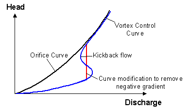
Suggested modification to vortex control curve
|
|
|
|
E2259
|
Subcatchment <subcatchment id> has been deleted/renamed since meshing was performed
|
Info
|
2D Zone ID, Subcatchment ID
|
|
Cause
|
The Subcatchment identified was used to create the current mesh in the 2D Zone, but no longer exists.
(Subcatchments are only used to create a mesh when the 2D Zone option Apply rainfall etc directly to mesh elements is selected and the Apply rainfall etc option is set to outside subcatchments.)
This error may be caused as a result of renaming of the Subcatchment.
|
|
Advice
|
Re-mesh the 2D Zone using the current set of subcatchments.
Alternatively, if the Subcatchment was renamed, reset the Subcatchment ID to the value used when the 2D mesh was created.
|
|
|
|
E2260
|
Subcatchment <subcatchment id> has had its boundary changed since meshing was performed
|
Info
|
2D Zone ID, Subcatchment ID
|
|
Cause
|
The boundary of a Subcatchment used to create the 2D Zone mesh was edited after the 2D mesh was created.
(Subcatchments are only used to create a mesh when the 2D Zone option Apply rainfall etc directly to mesh elements is selected and the Apply rainfall etc option is set to outside subcatchments.)
|
|
Advice
|
Re-mesh the 2D Zone using the current set of Subcatchment boundaries.
|
|
|
|
E2261
|
Subcatchment <subcatchment id> has been added since meshing was performed
|
Info
|
2D Zone ID, Subcatchment ID
|
|
Cause
|
The Subcatchment identified intersects a 2D Zone that has been meshed, but was not used to create the current mesh in the 2D Simulation Polygon.
(Subcatchments are only used to create a mesh when the 2D Zone option Apply rainfall etc directly to mesh elements is selected and the Apply rainfall etc option is set to outside subcatchments.)
This error may be caused by renaming of the Subcatchment.
|
|
Advice
|
Re-mesh the 2D Zone using the current set of Subcatchments.
Alternatively, if the Subcatchment was renamed, reset the Subcatchment ID to the value used when the 2D mesh was created.
|
|
|
|
E2263
|
River reach <river reach id> has been deleted/renamed since meshing was performed
|
Info
|
2D Zone ID, River Reach ID
|
|
Cause
|
The River Reach identified was used to create the current mesh in the 2D Zone, but no longer exists.
This error may be caused as a result of renaming of the nodes to which the River Reach is connected.
|
|
Advice
|
Re-mesh the 2D Zone using the current set of River Reaches.
Alternatively, if the River Reach was renamed, reset the IDs of the connecting nodes to the value used when the 2D mesh was created.
|
|
|
|
E2264
|
River reach <river reach id> has had its boundary changed since meshing was performed
|
Info
|
2D Zone ID, River Reach ID
|
|
Cause
|
The boundary of a River Reach used to create the 2D Zone mesh was edited after the 2D mesh was created.
|
|
Advice
|
Re-mesh the 2D Zone using the current River Reach boundary.
|
|
|
|
E2267
|
River reach <river reach id> has been added since meshing was performed
|
Info
|
2D Zone ID, River Reach ID
|
|
Cause
|
The River Reach identified intersects a 2D Zone that has been meshed, but was not used to create the current mesh in the 2D Zone.
This error may be caused by renaming of the nodes to which the River Reach is connected.
|
|
Advice
|
Re-mesh the 2D Zone using the current set of River Reaches.
Alternatively, if the River Reach was renamed, reset the IDs of the connecting nodes to the value used when the 2D mesh was created.
|
|
|
|
E2268
|
A value must be specified for this field when applying rainfall directly to mesh elements
|
Info
|
2D Zone ID
|
|
Cause
|
The Apply rainfall etc directly to mesh elements option of the 2D Zone has been selected, but a Rainfall Profile value has not been entered.
|
|
Advice
|
Enter a Rainfall Profile value.
|
|
|
|
E2270
|
Bridge <bridge id> has been deleted/renamed since meshing was performed
|
Info
|
2D Zone ID, Bridge ID
|
|
Cause
|
The Bridge identified was used to create the current mesh in the 2D Zone, but no longer exists.
This error may be caused as a result of renaming of the nodes to which the Bridge is connected.
|
|
Advice
|
Re-mesh the 2D Zone using the current set of Bridges.
Alternatively, if the Bridge was renamed, reset the IDs of the connecting nodes to the value used when the 2D mesh was created.
|
|
|
|
E2271
|
Bridge <bridge id> has had its boundary changed since meshing was performed
|
Info
|
2D Zone ID, Bridge ID
|
|
Cause
|
The boundary of a Bridge used to create the 2D Zone mesh was edited after the 2D mesh was created.
|
|
Advice
|
Re-mesh the 2D Zone using the current Bridge boundary.
|
|
|
|
E2272
|
Bridge <bridge id> has been added since meshing was performed
|
Info
|
2D Zone ID, Bridge ID
|
|
Cause
|
The Bridge identified intersects a 2D Zone that has been meshed, but was not used to create the current mesh in the 2D Zone.
This error may be caused by renaming of the nodes to which the Bridge is connected.
|
|
Advice
|
Re-mesh the 2D Zone using the current set of Bridges.
Alternatively, if the Bridge was renamed, reset the IDs of the connecting nodes to the value used when the 2D mesh was created.
|
|
|
|
E2273
|
Storage area <storage area id> has been deleted/renamed since meshing was performed
|
Info
|
2D Zone ID, Storage Area ID
|
|
Cause
|
The Storage Area identified was used to create the current mesh in the 2D Zone, but no longer exists.
This error may be caused as a result of renaming of the Storage Area.
|
|
Advice
|
Re-mesh the 2D Zone using the current set of Storage Areas.
Alternatively, if the Storage Area was renamed, reset the Storage Area ID to the value used when the 2D mesh was created.
|
|
|
|
E2274
|
Storage area <storage area id> has had its boundary changed since meshing was performed
|
Info
|
2D Zone ID, Storage Area ID
|
|
Cause
|
The boundary of a Storage Area used to create the 2D Zone mesh was edited after the 2D mesh was created.
|
|
Advice
|
Re-mesh the 2D Zone using the current Storage Area boundary.
|
|
|
|
E2275
|
Storage area <storage area id> has been added since meshing was performed
|
Info
|
2D Zone ID, Storage Area ID
|
|
Cause
|
The Storage Area identified intersects a 2D Zone that has been meshed, but was not used to create the current mesh in the 2D Zone.
This error may be caused by renaming of the Storage Area.
|
|
Advice
|
Re-mesh the 2D Zone using the current set of Storage Areas.
Alternatively, if the Storage Area was renamed, reset the Storage Area ID to the value used when the 2D mesh was created.
|
|
|
|
E2276
|
More than initial infiltration
|
Info
|
Runoff Surface ID
|
|
Cause
|
Applicable to Runoff Surfaces with Runoff Volume Type = Horton or HortonSWMM.
Limiting infiltration value > Initial infiltration value.
|
|
Advice
|
Check the Infiltration parameters of the reported Runoff Surface.
|
|
|
|
E2279
|
Not greater than 0.000
|
Info
|
Runoff Surface ID
|
|
Cause
|
Applicable to Runoff Surfaces with Runoff Volume Type = HortonSWMM.
Horton drying time value < 0
|
|
Advice
|
Check the Infiltration parameters of the reported Runoff Surface.
|
|
|
|
E2280
|
Less than minimum runoff
|
Info
|
Runoff Surface ID
|
|
Cause
|
Applicable to Runoff Surfaces with Runoff Volume Type = Wallingfrd.
Wal. Proc. Minimum runoff value > Wal. Proc. Maximum runoff value.
|
|
Advice
|
Check the runoff parameters of the reported Runoff Surface.
|
|
|
|
E2281
|
Infiltration zone (2D) <infiltration zone id> has been
added since meshing was performed
|
Info
|
2D Zone ID, Infiltration Zone ID
|
|
Cause
|
The Infiltration Zone identified intersects a 2D Zone that has been meshed, but was not used to create the current mesh in the 2D Zone.
This error may be caused by renaming of the Infiltration Zone.
|
|
Advice
|
Re-mesh the 2D Zone using the current set of infiltration zones.
Alternatively, if the Infiltration Zone was renamed, reset the Infiltration Zone ID to the value used when the 2D mesh was created.
|
|
|
|
E2281
|
This runoff volume type is inappropriate
for impervious surfaces
|
Info
|
Runoff Surface ID
|
|
Cause
|
Applicable to Runoff Surfaces with Runoff Volume Type = Horton, HortonSWMM, NewUK, GreenAmpt, ConstInf and UKWIRPerv.
Surface Type field has been set to Impervious.
|
|
Advice
|
Check the Runoff Surface parameters are as expected.
|
|
|
|
E2282
|
SCS initial loss is only valid on
SCS and CN runoff volumes
|
Info
|
Runoff Surface ID
|
|
Cause
|
Applicable to Runoff Surfaces using Runoff Volume Types other than SCS and CN.
Initial Loss Type field has been set to SCS.
|
|
Advice
|
Check the Runoff Surface parameters are as expected.
|
|
|
|
E2283
|
ReFH runoff volume type must have ReFH runoff routing type
|
Info
|
Runoff Surface ID
|
|
Cause
|
Runoff Volume Type is ReFH but Routing Model is not ReFH or vice versa.
|
|
Advice
|
Check the Runoff Surface parameters are as expected.
|
|
|
|
E2284
|
This runoff volume type is inappropriate
for pervious surfaces
|
Info
|
Runoff Surface ID
|
|
Cause
|
Applicable to Runoff Surfaces with Runoff Volume Type = UKWIRPaved.
Surface Type field has been set to Pervious.
|
|
Advice
|
Check the Runoff Surface parameters are as expected.
|
|
|
|
E2287
|
Minimum element area has changed since meshing was performed
|
Info
|
2D Zone ID
|
|
Cause
|
The value of the Minimum element area field has been changed since the current 2D mesh was created.
|
|
Advice
|
Re-mesh the 2D Zone using the current minimum element area.
|
|
|
|
E2287
|
The 'Cascade' routing model does not support the 'Rel' routing type, except when the number of reservoirs is zero
|
Info
|
Runoff Surface
|
|
Cause
|
The Routing model is set to Cascade, the Runoff routing type is set to Rel and the specified Number of reservoirs is greater than zero, but the Cascade model can only be used with a Rel routing type if the number of reservoirs is set to 0.
|
|
Advice
|
Either select a different Routing model or Runoff routing type, or if you want to use the Cascade model with Runoff routing type set to Rel, change the Number of reservoirs to 0.
|
|
|
|
E2288
|
Mesh zone <mesh zone id> has had its minimum element area changed since meshing was performed
|
Info
|
2D Zone ID, Mesh Zone ID
|
|
Cause
|
The value of the Minimum element area field or the status of the Override 2D zone minimum element area field has been changed since the current 2D mesh was created.
|
|
Advice
|
Re-mesh the 2D Zone using the current mesh zone settings.
|
|
|
|
E2292
|
Terrain-sensitive meshing option has changed since meshing was performed
|
Info
|
2D Zone ID
|
|
Cause
|
The status of the Terrain-sensitive msehing field of the 2D Zone has been changed since the current 2D mesh was created.
|
|
Advice
|
Re-mesh the 2D Zone using the current settings.
|
|
|
|
E2294
|
Maximum height variation must be specified for terrain-sensitive meshing
|
Info
|
2D Zone ID
|
|
Cause
|
The Terrain-sensitive meshing option for the 2D Zone has been checked, but a value has not been entered in the Maximum height variation field.
|
|
Advice
|
Enter a Maximum height variation for the 2D Zone.
|
|
|
|
E2295
|
Linear Structure (2D) <linear structure id> has
been deleted/renamed since meshing was performed
|
Info
|
2D Zone ID, Linear Structure (2D) ID
|
|
Cause
|
The Linear Structure (2D) identified was used to create the current mesh in the 2D Zone, but no longer exists.
This error may be caused as a result of renaming of the Linear Structure (2D).
|
|
Advice
|
Re-mesh the 2D Zone using the current set of Linear Structure (2D) objects.
Alternatively, if the Linear Structure (2D) was renamed, reset the ID to the value used when the 2D mesh was created.
|
|
|
|
E2296
|
Linear Structure (2D) <linear structure id> has had
its boundary changed since meshing was performed
|
Info
|
2D Zone ID, Linear Structure (2D) ID
|
|
Cause
|
The Linear Structure (2D) identified intersects a 2D Zone that has been meshed, but was not used to create the current mesh in the 2D Zone.
This error may be caused by renaming of the Linear Structure (2D).
|
|
Advice
|
Re-mesh the 2D Zone using the current set of Linear Structure (2D) objects.
Alternatively, if the Linear Structure (2D) was renamed, reset the ID to the value used when the 2D mesh was created.
|
|
|
|
E2297
|
Linear Structure (2D) <linear structure id> has
been added since meshing was performed
|
Info
|
2D Zone ID, Linear Structure (2D) ID
|
|
Cause
|
The Linear Structure (2D) identified intersects a 2D Zone that has been meshed, but was not used to create the current mesh in the 2D Zone.
This error may be caused by renaming of the Linear Structure (2D).
|
|
Advice
|
Re-mesh the 2D Zone using the current set of Linear Structure (2D) objects.
Alternatively, if the Linear Structure (2D) was renamed, reset the ID to the value used when the 2D mesh was created.
|
|
|
|
E2298
|
Base linear Structure (2D) <base linear structure id> has
had its sluice/bridge (2D) sub-structures changed since meshing was performed
|
Info
|
2D Zone ID, Base Linear Structure (2D) ID
|
|
Cause
|
May be caused by the following:
- Fields affecting the geometry of a Sluice / Bridge Linear Structure (2D) object associated with the Base Linear Structure (2D) identified have been changed since the 2D Zone was meshed.
- A new Sluice / Bridge Linear Structure (2D) object has been associated with the Base Linear Structure (2D), or an existing associated object has been renamed.
- A Sluice /Bridge Linear Structure (2D) object that was associated with the Base Linear Structure (2D) is no longer associated with the structure, or has been renamed.
|
|
Advice
|
Re-mesh the 2D Zone using the current set of Sluice /Bridge Linear Structure (2D) objects.
|
|
|
|
E2299
|
Mesh zone <mesh zone id> has had its ground level modification type changed since meshing was performed
|
Info
|
Mesh Zone ID
|
|
Cause
|
The Ground level modification field of the Mesh Zone identified has been changed since the current mesh in the 2D Zone was created.
|
|
Advice
|
Re-mesh the 2D Zone using the current mesh zone settings.
|
|
|
|
E2300
|
Mesh zone <mesh zone id> has had its level adjustment changed since meshing was performed
|
Info
|
Mesh Zone ID
|
|
Cause
|
The Raise by or Level field (used for ground level modification) of the Mesh Zone identified has been changed since the current mesh in the 2D Zone was created.
|
|
Advice
|
Re-mesh the 2D Zone using the current mesh zone settings.
|
|
|
|
E2301
|
No corresponding surface index in
land use
|
Info
|
Subcatchment ID
|
|
Cause
|
A value has been specified in a Subcatchment Runoff Area with no corresponding Surface ID defined in the associated Land Use.
|
|
Advice
|
Check that all Surface IDs have been defined in Land Use associated with the reported Subcatchment.
|
|
|
|
E2302
|
Not in land use set
|
Info
|
Subcatchment ID
|
|
Cause
|
Node selected in Subcatchment Land Use ID field does not exist or Land Use ID has not been specified.
|
|
Advice
|
Check that correct Subcatchment Land Use ID has been selected.
|
|
|
|
E2304
|
Time to peak must be greater than or equal to zero
|
Info
|
Subcatchment ID
|
|
Cause
|
Time to peak field on the Runoff Page of the Subcatchment Property Sheet is less than zero and the Routing Model field on the Runoff Surfaces grid is set to Unit, SCS Unit or ReFH.
|
|
Advice
|
Enter a Time to peak value greater than or equal to zero for the Subcatchment.
|
|
|
|
E2305
|
Base time must be greater than or equal to zero
|
Info
|
Subcatchment ID
|
|
Cause
|
Base time field on the Runoff Page of the Subcatchment Property Sheet is less than zero and the Routing Model field on the Runoff Surfaces grid is set to Unit or SCS Unit.
|
|
Advice
|
Enter a Base time value for the Subcatchment.
|
|
|
|
E2306
|
Catchment dimension must be non-zero
|
Info
|
Subcatchment ID
|
|
Cause
|
Applies to Subcatchments where Runoff Surfaces use Routing Model: SWMM, Desbordes or LargeCatch:
The warning message will be displayed if there is a contributing surface area (sum of the Subcatchment Runoff Areas > 0) but the Subcatchment Dimension field <= 0.
|
|
Advice
|
Check the Subcatchment Parameters.
|
|
|
|
E2307
|
Not in node set
|
Info
|
Subcatchment ID
|
|
Cause
|
Node selected in the Subcatchment Node ID or Ground infiltration node field does not exist or Node ID has not been specified.
|
|
Advice
|
Check that correct Subcatchment Node ID has been selected.
|
|
|
|
E2308
|
Nonexistent link <link sufffix> specified to drain to
|
Info
|
Subcatchment
|
|
Cause
|
The subcatchment is specified to drain to a link but the specified link suffix does not exist.
|
|
Advice
|
Check the subcatchment definition is as expected.
|
|
|
|
E2310
|
Subcatchments cannot drain to outfalls
|
Info
|
Subcatchment
|
|
Cause
|
Node selected in Subcatchment Node ID field is of type Outfall.
|
|
Advice
|
Check that the correct node has been selected in the Subcatchment Node ID field.
|
|
|
|
E2311
|
Not in ground infiltration set
|
Info
|
Subcatchment ID
|
|
Cause
|
Ground Infiltration data selected in the Ground Infiltration ID field of the Subcatchment object has not been defined.
|
|
Advice
|
Define new Ground Infiltration data or select an existing Ground Infiltration.
|
|
|
|
E2315
|
An ReFH unit hydrograph must be defined if the routing model is of type ReFH
|
Info
|
Subcatchment ID
|
|
Cause
|
The runoff surface associated with the subcatchment is an ReFH surface, but the Unit hydrograph definition specified is not ReFH.
|
|
Advice
|
Set Unit hydrograph definition to ReFH for ReFH runoff surfaces.
|
|
|
|
E2317
|
Incorrect routing definition for this routing model
|
Info
|
Subcatchment ID
|
|
Cause
|
The Unit hydrograph definition specified for the subcatchment can not be used with the Routing Model selected for the associated runoff surface.
For example, a Routing Model of Snyder Unit can only use a Unit Hydrograph Definition of Snyder.
|
|
Advice
|
Check Subcatchment Unit hydrograph definition and Runoff Surface Routing Model fields are set as expected.
|
|
|
|
E2318
|
Network results line (2D) <results line ID> has
been deleted/renamed since meshing was performed
|
Info
|
2D Zone ID, Network Results Line (2D) ID
|
|
Cause
|
The Network Results Line (2D) identified was used to create the current mesh in the 2D Zone, but no longer exists.
This error may be caused as a result of renaming of the network results line.
|
|
Advice
|
Re-mesh the 2D Zone using the current set of Network Results Lines.
Alternatively, if the results line was renamed, reset the results line ID to the value used when the 2D mesh was created.
|
|
|
|
E2319
|
Network results line (2D) <results line ID> has
had its boundary changed since meshing was performed
|
Info
|
2D Zone ID, Network Results Line (2D) ID
|
|
Cause
|
The boundary of a Network Results Line (2D) used to create the 2D Zone mesh was edited after the 2D mesh was created.
|
|
Advice
|
Re-mesh the 2D Zone using the current Network Results Line boundary.
|
|
|
|
E2319
|
Inline Bank has RTC but invalid 2D Zone
|
Info
|
Inline Bank ID
|
|
Cause
|
RTC Definitions have been specified in the Section data of the Inline Bank and either a 2D Zone ID has not been specified, or a 2D Zone ID that does not exist in the network has been specified.
|
|
Advice
|
Connect the Inline Bank to a 2D Zone by specifying a valid 2D zone ID.
|
|
|
|
E2320
|
Network results line (2D) <results line ID> has
been added since meshing was performed
|
Info
|
2D Zone ID, Network Results Line (2D) ID
|
|
Cause
|
The Network Results Line (2D) identified intersects a 2D Zone that has been meshed, but was not used to create the current mesh in the 2D Zone.
This error may be caused by renaming of the Network Results Line (2D).
|
|
Advice
|
Re-mesh the 2D Zone using the current set of Network Results Lines.
Alternatively, if the line was renamed, reset the ID to the value used when the 2D mesh was created.
|
|
|
|
E2321
|
Network results polygon (2D) <results polygon ID> has
been deleted/renamed since meshing was performed
|
Info
|
2D Zone ID, Network Results Polygon (2D) ID
|
|
Cause
|
The Network Results Polygon (2D) identified was used to create the current mesh in the 2D Zone, but no longer exists.
This error may be caused as a result of renaming of the network results polygon.
|
|
Advice
|
Re-mesh the 2D Zone using the current set of Network Results Polygons.
Alternatively, if the results polygon was renamed, reset the results polygon ID to the value used when the 2D mesh was created.
|
|
|
|
E2322
|
Network results polygon (2D) <results polygon ID> has
had its boundary changed since meshing was performed
|
Info
|
2D Zone ID, Network Results Polygon (2D) ID
|
|
Cause
|
The boundary of a Network Results Polygon (2D) used to create the 2D Zone mesh was edited after the 2D mesh was created.
|
|
Advice
|
Re-mesh the 2D Zone using the current Network Results Polygon boundary.
|
|
|
|
E2323
|
Network results polygon (2D) <results polygon ID> has
been added since meshing was performed
|
Info
|
2D Zone ID, Network Results Polygon (2D) ID
|
|
Cause
|
The Network Results Polygon (2D) identified intersects a 2D Zone that has been meshed, but was not used to create the current mesh in the 2D Zone.
This error may be caused by renaming of the Network Results Polygon (2D).
|
|
Advice
|
Re-mesh the 2D Zone using the current set of Network Results Polygons.
Alternatively, if the polygon was renamed, reset the ID to the value used when the 2D mesh was created.
|
|
|
|
E2326
|
Runoff surfaces have different routing
models
|
Info
|
Land Use ID
|
|
Cause
|
The Runoff Surfaces associated with the Land Use object have different Routing Models.
|
|
Advice
|
Check the correct Runoff Surfaces have been associated with the reported Land Use object.
|
|
|
| E2326 |
Stream name required
|
Info
|
Spatial rain source ID
|
|
Cause
|
The Stream name or category field is blank.
|
|
Advice
|
Specify a TSDB or STDSB data stream or a TVD connector Category.
|
|
|
|
E2327
|
This surface is not defined in runoff
surfaces
|
Info
|
Land Use ID
|
|
Cause
|
The ID of a Runoff Surface that does not exist has been included in the Land Use Surfaces grid.
|
|
Advice
|
Define a new Runoff Surface or select an existing Runoff Surface.
|
|
|
|
E2328
|
A value must be specified for this field
|
Info
|
Subcatchment ID
|
|
Cause
|
The runoff routing model selected for the Runoff Surface for this subcatchment requires a Time to Peak (Tp) value, but a value for Tp has not been specified.
|
|
Advice
|
Specify a value for Tp on the Runoff page of the Subcatchment property sheet.
|
|
|
|
E2329
|
1D Results object associated with invalid upstream node
|
Info
|
Network Results Point (1D) ID
|
|
Cause
|
The node specified in the US node ID field of the Network Results Point (1D) does not exist in the network.
|
|
Advice
|
Specify a valid US node ID.
|
|
|
|
E2329
|
A value must be specified for this field
|
Info
|
Subcatchment ID
|
|
Cause
|
The runoff routing model selected for the Runoff surface for this subcatchment requires a Base time (Tb) value, but a value for Tb has not been specified.
|
|
Advice
|
Specify a value for Tb on the Runoff page of the Subcatchment property sheet.
|
|
|
|
E2329
|
You can only mix New UK runoff volume surfaces with fixed runoff volume surfaces
|
Info
|
Land Use ID
|
|
Cause
|
Runoff Surfaces associated with the reported Land Use include those of Runoff Volume Type = NewUK and Runoff Volume Type other than Fixed
|
|
Advice
|
Check that the correct Runoff Surfaces have been associated with the reported Land Use object.
Check the Runoff Volume Types assigned to associated Runoff Surfaces.
|
|
|
|
E2330
|
A Green-Ampt runoff volume surface
can only be the last defined surface for a land use
|
Info
|
Land Use ID
|
|
Cause
|
More than one Runoff Surface associated with the reported Land Use is of Runoff Volume Type = GreenAmpt
or
A Runoff Surface of Runoff Volume Type = GreenAmpt is associated with the reported Land Use but is not the last surface in the Surfaces Tab of the Runoff Surfaces Property Sheet
|
|
Advice
|
Check that the correct Runoff Surfaces have been associated with the reported Land Use object.
Check the Runoff Volume Types assigned to associated Runoff Surfaces.
|
|
|
|
E2330
|
1D Results object associated with invalid link suffix
|
Info
|
Network Results Point (1D) ID
|
|
Cause
|
The link specified by the US node ID and Link suffix field of the Network Results Point (1D) does not exist in the network.
The node exists, but the link suffix is incorrect.
|
|
Advice
|
Specify a valid Link suffix.
|
|
|
|
E2331
|
1D Results object associated with invalid bridge opening
|
Info
|
Network Results Point (1D) ID
|
|
Cause
|
The bridge opening specified by the Bridge opening ID field of the Network Results Point (1D) does not exist in the network.
|
|
Advice
|
Specify a valid Bridge opening ID.
|
|
|
|
E2332
|
1D Results object must be associated with a link or bridge opening
|
Info
|
Network Results Point (1D) ID
|
|
Cause
|
Neither a Bridge opening ID or US node ID and Link suffix has been specified for the Network Results Point 1D
|
|
Advice
|
Specify a valid Bridge opening ID or valid US node ID and Link suffix.
|
|
|
|
E2332
|
Can only mix Wallingford runoff volume
surfaces with fixed runoff volume surfaces
|
Info
|
Land Use ID
|
|
Cause
|
Runoff Surfaces associated with the reported Land Use include those of Runoff Volume Type = Wallingford and Runoff Volume Type other than Fixed
|
|
Advice
|
Check that the correct Runoff Surfaces have been associated with the reported Land Use object.
Check the Runoff Volume Types assigned to associated Runoff Surfaces.
|
|
|
|
E2333
|
Damage receptor <damage receptor id> has been deleted/renamed since 2d elements were last assigned
|
Info
|
2D Zone ID, Damage Receptor ID
|
|
Cause
|
The Damage Receptor identified was used to assign 2D elements to Damage Receptors, but no longer exists.
This error may be caused as a result of renaming of the Damage Receptor.
|
|
Advice
|
Re-assign the 2D elements using the current set of Damage Receptors.
Alternatively, if the Damage Receptor was renamed, reset the Damage Receptor ID to the value used when the 2D elements were assigned.
|
|
|
|
E2334
|
PDM runoff volume surface must be the first and only runoff surface
|
Info
|
Land Use ID
|
|
Cause
|
Multiple runoff surfaces associated with the reported Land Use including those of Runoff Volume Type = PDM.
A PDM runoff surface must be the only runoff surface associated with a subcatchment.
|
|
Advice
|
Check that the correct Runoff Surfaces have been associated with the reported Land Use object.
Check the Runoff Volume Types assigned to associated Runoff Surfaces.
|
|
|
|
E2335
|
Can only mix UKWIR surfaces with other UKWIR surfaces
|
Info
|
Land Use ID
|
|
Cause
|
Runoff Surfaces associated with the reported Land Use include those of Runoff Volume Type = UKWIRPaved or UKWIRPerv and Runoff Volume Type other than a UKWIR type.
|
|
Advice
|
Check that the correct Runoff Surfaces have been associated with the reported Land Use object.
Check the Runoff Volume Types assigned to associated Runoff Surfaces.
|
|
|
|
E2336
|
Cannot have more than one CNSWMM runoff volume surface
|
Info
|
Land use ID
|
|
Cause
|
Runoff surfaces associated with the reported Land use include more than one whose Runoff volume type is set to CNSWMM.
|
|
Advice
|
Check that there is only one Runoff surface, which is associated with the reported Land use object, that has a Runoff volume type set to CNSWMM.
|
|
|
|
E2337
|
Can only mix CNSWMM runoff volume surfaces with Fixed runoff volume surfaces
|
Info
|
Land use ID
|
|
Cause
|
Runoff surfaces associated with the reported Land Use include those of Runoff volume type = CNSWMM and Runoff volume type other than a Fixed type.
|
|
Advice
|
Check that the correct Runoff surfaces have been associated with the reported Land use object.
Check the runoff volume types assigned to the associated Runoff surfaces.
|
|
|
|
E2340
|
Inline Bank has 2D Zone specified but is not connected to an Outfall node
|
Info
|
Inline Bank ID
|
|
Cause
|
A 2D Zone ID has been specified for the Inline Bank, but the inline bank is not connected to an Outfall node.
Note: to model flow between the 1D network and a 2D mesh, the inline bank must be connected to a node of type Outfall, not Outfall 2D. An inline bank connected to a node of type Outfall 2D will be treated as a 1D link with flow entering the 2D zone at a point.
|
|
Advice
|
Connect the Inline Bank to a node of Node type Outfall.
|
|
|
|
E2341
|
A value must be specified for this field
|
Info
|
Subcatchment ID
|
|
Cause
|
An RefH runoff surface is associated with the subcatchment, but no unit hydrograph Time to peak, tp value has been specified.
|
|
Advice
|
Enter a Time to peak, tp value for the subcatchment.
|
|
|
|
E2342
|
Unit hydrograph peak must be greater than or equal to zero
|
Info
|
Subcatchment ID
|
|
Cause
|
Unit hydrograph Time to peak, tp value specified is less than zero.
|
|
Advice
|
Enter a Time to peak, tp value greater than or equal to zero for the subcatchment.
|
|
|
|
E2343
|
A value must be specified for this field
|
Info
|
Subcatchment ID
|
|
Cause
|
An RefH runoff surface is associated with the subcatchment, but no unit hydrograph Degree of kink value has been specified.
|
|
Advice
|
Enter a Degree of kink value for the subcatchment.
|
|
|
|
E2344
|
Degree of kink must be greater than or equal to zero
|
Info
|
Subcatchment ID
|
|
Cause
|
Unit hydrograph Degree of kink value specified is less than zero.
|
|
Advice
|
Enter a Degree of kink value greater than or equal to zero for the subcatchment.
|
|
|
|
E2348
|
A value must be specified for this field when runoff volume type is SRM or PDM on first runoff surface referenced
|
Info
|
Subcatchment ID
|
|
Cause
|
Runoff surface 1 of the Land Use associated with the reported Subcatchment is set to runoff surface with Runoff Volume Type = SRM or PDM and a value has not been entered in subcatchment SRM field, Baseflow calculation field or Soil moisture deficit field.
|
|
Advice
|
Enter value in subcatchment field causing validation error.
|
|
|
|
E2349
|
Must reference a PDM descriptor when baseflow calculation or soil moisture deficit set to 'PDM' and runoff surface runoff volume type is SRM
|
Info
|
Subcatchment ID
|
|
Cause
|
Runoff surface 1 of the Land Use associated with the reported Subcatchment is set to runoff surface with Runoff Volume Type = SRM and subcatchment Baseflow calculation and/or Soil moisture deficit fields are set to PDM, but a value has not been entered in the PDM descriptor field.
|
|
Advice
|
Enter value in subcatchment PDM descriptor field.
|
|
|
|
E2350
|
Must reference a PDM descriptor when runoff surface runoff volume type is PDM
|
Info
|
Subcatchment ID
|
|
Cause
|
Runoff surface 1 of the Land Use associated with the reported Subcatchment is set to runoff surface with Runoff Volume Type = PDM and a value has not been entered in subcatchment PDM descriptor field.
|
|
Advice
|
Enter value in subcatchment PDM descriptor field.
|
|
|
|
E2351
|
HOST SPR calculations need HOST soil class set
|
Info
|
Subcatchment ID
|
|
Cause
|
SPR calculation is set to HOST_Soils or HOST_FEH, but HOST soil class is not set.
|
|
Advice
|
Enter value in subcatchment HOST soil class field.
|
|
|
|
E2352
|
HOST predominant soils cannot have HOST soil class 28
|
Info
|
Subcatchment ID
|
|
Cause
|
SPR calculation is set to HOST_Soils and HOST soil class is set to 28.
(HOST predominant soils has no SPR defined for HOST=28)
|
|
Advice
|
Enter value in subcatchment HOST soil class field other than 28.
|
|
|
|
E2353
|
Standard percentage runoff must be set
|
Info
|
Subcatchment ID
|
|
Cause
|
Associated runoff surface is of type UKWIR, but Standard percentage runoff has not been set.
|
|
Advice
|
Enter value in subcatchment Standard percentage runoff field.
|
|
|
|
E2354
|
Value must be strictly greater than zero
|
Info
|
Subcatchment ID
|
|
Cause
|
Associated runoff surface has Routing model of type Non-linear, but subcatchment Slope has not been set or is less than zero.
(Slope is used to calculate values of K, p and lag time.)
or
Subcatchment Total area is greater than 2km2, Unit hydrograph definition is set to Rational and Time of concentration method is set to Kraven, but subcatchment Slope, Equivalent Manning's n or Hydraulic radius have been set to value less than or equal to zero.
(Slope, equivalent roughness and hydraulic radius are used to calculate flood wave celerity when catchment area is greater than 2km2.)
|
|
Advice
|
Enter value in subcatchment field.
|
|
|
|
E2355
|
ReFH/ReFH2 parameters are inconsistent with catchment descriptors
|
Info
|
Subcatchment ID
|
|
Cause
|
A catchment descriptor or option such as Country has been edited and is its parameter is no longer consistent with the specified ReFH or ReFH2 model.
or
The catchment descriptors are loaded and are different from the existing descriptors.
or
The parameters are imported from ReFH2 but the descriptors don’t match those on the dialog and they have not been updated.
or
The method for a descriptor is switched to “Design” and the design value is not available (either because it hasn’t been calculated yet or because the method was “User” when the dialog was opened).
|
|
Advice
|
Check that either the correct parameters or the model value is specified in subcatchment field.
|
|
|
|
E2356
|
Can only specify one of Node ID, To subcatchment ID, Lateral Links, 2D point source
|
Info
|
Subcatchment
|
|
Cause
|
More than one of the Drains to options has been specified for the subcatchment.
|
|
Advice
|
Check that the subcatchment only drains to either a Node ID or a To subcatchment ID or a set of Lateral links or a 2D point ID.
|
|
|
|
E2357
|
Must specify either a node , a link, a subcatchment, a 2D point source or a set of lateral links to drain to
|
Info
|
Subcatchment
|
|
Cause
|
The Drains to option for the subcatchment has not been specified.
|
|
Advice
|
Select the applicable option from the Drains to field and ensure that the name of the relevant object this subcatchment is to drain to is specified in the applicable Node ID, Link ID, To subcatchment ID or 2D point source field or in the Lateral links grid.
|
|
|
|
E2358
|
No subcatchment exists with this ID
|
Info
|
Subcatchment
|
|
Cause
|
The specified To subcatchment ID does not correspond to any subcatchment in the network.
|
|
Advice
|
Choose a subcatchment from the drop-down list in the To subcatchment ID field or create a new subcatchment with the required name/ID.
|
|
|
|
E2359
|
Cannot specify own ID as subcatchment to drain to
|
Info
|
Subcatchment
|
|
Cause
|
The name specified in the To subcatchment ID has the same name as the subcatchment. A subcatchment cannot drain into itself.
|
|
Advice
|
Choose a different subcatchment to drain to from the drop-down list in the To subcatchment ID field.
|
|
|
|
E2360
|
Specified ID results in a closed loop of drain to subcatchments
|
Info
|
Subcatchment
|
|
Cause
|
Following the chain of subcatchments specified in successive To subcatchment ID forms a closed loop.
|
|
Advice
|
To break the loop, choose a different subcatchment to drain to from the drop-down list in the To subcatchment ID field.
|
|
|
|
E2362
|
Uses ReFH2 version <number>. Other subcatchments in network use ReFH2 version <number>
|
Info
|
Subcatchment
|
|
Cause
|
The subcatchments in the network use different versions of ReFH2.
|
|
Advice
|
Ensure that all the subcatchments use the same version of ReFH2.
|
|
|
|
E2366
|
Unit hydrograph definition must be 'Name' if runoff surface has routing model 'Name'
|
Info
|
Subcatchment
|
|
Cause
|
The unit hydrograph selected in the Unit hydrograph definition field is different to that used by the routing model specified for the runoff surface. These must be the same.
|
|
Advice
|
Choose the relevant unit hydrograph from the drop-down list in the Unit hydrograph definition field.
|
|
|
|
E2367
|
Runoff surface must have routing model 'Name' if unit hydrograph definition is 'Name'
|
Info
|
Subcatchment
|
|
Cause
|
The routing model specified for the runoff surface uses a different unit hydrograph to that selected in the Unit hydrograph definition field. These must be the same.
|
|
Advice
|
Choose the relevant model from the dropdown list in the Routing model field on the Runoff surface tab in the Subcatchment grid.
Alternatively, access the Routing model field from the subcatchment property sheet by clicking  next to the Land use ID field and selecting the option from the context menu to display the Land use Object Properties sheet. Then click next to the relevant Runoff Surface field on the Land use Object Properties sheet and select the option from the context menu. This displays the Runoff surface Object Properties sheet from which the relevant Routing model can be selected. next to the Land use ID field and selecting the option from the context menu to display the Land use Object Properties sheet. Then click next to the relevant Runoff Surface field on the Land use Object Properties sheet and select the option from the context menu. This displays the Runoff surface Object Properties sheet from which the relevant Routing model can be selected.
|
|
|
|
E2368
|
Must specify a set of lateral links to drain to
|
Info
|
Subcatchment
|
|
Cause
|
You have specified that subcatchment must Drain to Multiple links but have not specified which links should be used.
|
|
Advice
|
Specify which links the subcatchment should drain to in the Lateral links field.
|
|
|
| E2370 |
Groundwater cannot drain to outfalls
|
Info
|
Subcatchment
|
|
Cause
|
The Ground infiltration node is currently set to an outfall type of node but ground water cannot drain to an outfall node.
|
|
Advice
|
Select another ground infiltration node for the ground water to flow to.
|
|
|
| E2374 |
SUDS structures' total area greater than that of the subcatchment
|
Info
|
Subcatchment
|
|
Cause
|
The total area of all the SUDS structures (Area x Number of units) located within this subcatchment is greater than the area of the subcatchment.
|
|
Advice
|
Check the Area and Number of units entries for each SUDS structure.
|
|
|
|
E2376
|
A headloss curve must contain 2-15
entries
|
Info
|
Headloss Curve ID
|
|
Cause
|
Ratio / Value Grid of the Headloss Curve contains < 2 or > 15 rows.
|
|
Advice
|
Check the Ratio / Value Grid entries of the reported Headloss Curve.
|
|
|
|
E2377
|
A headloss curve must contain 2-15
entries
|
Info
|
Headloss Curve ID
|
|
Cause
|
Velocity / Value Grid of the Headloss Curve contains < 2 or > 15 rows.
|
|
Advice
|
Check the Velocity / Value Grid entries of the reported Headloss Curve.
|
|
|
|
E2380
|
When not 'None' must have 'Recharge and Runoff' set to 'Standard' and 'Soil moisture distribution' set to 'Pareto'
|
Info
|
PDM Descriptor ID
|
|
Cause
|
The Interflow field of the PDM descriptor has been set to a value other than None and Recharge and runoff is not set to Standard and/or Soil moisture distribution is not set to Pareto.
|
|
Advice
|
Review the settings for the Interflow, Recharge and runoff and Soil moisture distribution fields.
|
|
|
| E2381 |
A subcatchment with an RTK hydrograph must drain to a node if sim parameter "Use SWMM5 RDII" is selected
|
Info
|
RTK hydrograph
|
|
Cause
|
The Drains to field for the subcatchment is not currently set to Node.
|
|
Advice
|
Check that the Drains to field for the subcatchment is set to Node if SWMM5 RDII is to be used in the simulation.
Alternatively, uncheck the Use SWMM5 RDII option in the simulation parameters if this subcatchment is to drain to an object other than a node. Note that Monthly RTK Hydrographs can only be used in a simulation if the Use SWMM5 RDII option is selected.
|
|
|
|
E2382
|
Unit Hydrograph <ID> associated with multiple rainfall profiles (<Profile numbers>)
|
Info
|
Subcatchment
|
|
Cause
|
Subcatchments cannot use the same RTK hydrograph with different rainfall profiles.
|
|
Advice
|
Ensure that the subcatchments that use the same RTK hydrograph use the same rainfall profile.
|
|
|
|
E2384
|
Another subcatchment also with an RTK hydrograph drains to the same node and SWMM5 RDII is selected
|
Info
|
Node ID
|
|
Cause
|
The Use SWMM5 RDII option is selected in the simulation parameters but this subcatchment drains to the same node as another subcatchment for which an RTK Hydrograph is also specified; only one subcatchment with an RTK Hydrograph defined for it can drain to this node.
|
|
Advice
|
Check the specified Node ID and change if necessary.
Alternatively, uncheck the Use SWMM5 RDII box in the simulation parameters. Note that Monthly RTK Hydrographs can only be used in a simulation if the Use SWMM5 RDII option is selected.
|
|
|
|
E2385
|
<SUDS Structure ID> has product Area X (number of Units) greater than the area of surface(s) it occupies
|
Info
|
SUDS controls
|
|
Cause
|
The total area occupied by a SUDS structure (i.e. SUDS structure area × number of units) exceeds the area of the surface(s) on which they are located.
|
|
Advice
|
Check that the correct values have been entered in the Area and /or Number of units fields, or that the correct Surface has been selected for the SUDS control object.
|
|
|
|
E2388
|
Must not be less than 0.01 when routing model is 'RAFTS'
|
Info
|
Subcatchment
|
|
Cause
|
The value specified for the Equivalent Manning's n field is less than the permitted minimum value of 0.01, when the runoff routing model is set to RAFTS.
|
|
Advice
|
Either change the value for the Equivalent Manning's n field to one that is within the permitted range of 0.01 to 0.1, or choose a different routing model.
|
|
|
|
E2389
|
Must not exceed 0.10 when routing model is 'RAFTS'
|
Info
|
Subcatchment
|
|
Cause
|
The value specified for the Equivalent Manning's n field is more than the permitted maximum value of 0.1, when the runoff routing model is set to RAFTS.
|
|
Advice
|
Change the value for the Equivalent Manning's n field to one that is within the permitted range of 0.01 to 0.1, or choose a different routing model.
|
|
|
|
E2390
|
Value must be greater than zero
|
Info
|
Subcatchment
|
|
Cause
|
The value specified for the Storage factor K is not greater than zero (0).
If the runoff routing model is set to Cascade or Non-linear, then Storage factor K must be greater than zero.
|
|
Advice
|
Change the value for the Storage factor K field to one that is greater than zero (>0), or check that the correct routing model has been specified.
If you want to use the Cascade routing model with a Storage factor K set to 0, then ensure, for all subcatchment surfaces, that either the Number of reservoirs is set to 0, or, the Runoff routing type is set to ABS and the Runoff routing value is greater than zero.
If you want to use the Non-linear routing model with a Storage factor K set to 0, then ensure, for all subcatchment surfaces, that either the Number of reservoirs is set to 0, or, the Runoff routing value is greater than zero.
|
|
|
| E2392 |
When unit hydrograph definition is set to 'Rational' a time of concentration method must be selected
|
Info
|
Subcatchment ID
|
|
Cause
|
No option has been selected for the time of concentration method. When the Unit hydrograph definition is set to Rational, a method for calculating the time of concentration must be specified. |
|
Advice
|
Select a method in the Time of concentration method field for the subcatchment identified in the message. |
|
|
| E2393 |
Element <element_ID>: Assigned node not found
|
Info
|
Subcatchment ID
|
|
Cause
|
A node has been specified in the Drain to node field of the SUDs control structure that is associated with this subcatchment, but this node does not exist.
|
|
Advice
|
Ensure that the applicable node is specified in the Drain to node field of the SUDs control structure properties. If the correct node has been specified, then check that it has been added to the relevant network.
|
|
|
| E2394 |
Element <element_ID>: Assigned subcatchment not found
|
Info
|
Subcatchment ID
|
|
Cause
|
A subcatchment has been specified in the Drain to subcatchment field of the SUDs control structure that is associated with this subcatchment, but this subcatchment does not exist.
|
|
Advice
|
Ensure that the applicable subcatchment is specified in the Drain to subcatchment field of the SUDs control structure properties. If the correct subcatchment has been specified, then check that it has been added to the relevant network.
|
|
|
|
E2395
|
Must specify 2D point source to drain to
|
Info
|
Subcatchment
|
|
Cause
|
The Drains to field is set to 2D point source but you have not specified a 2D point source in the 2D point ID field.
|
|
Advice
|
Specify which 2D point source, in the 2D point ID field, that this subcatchment is to drain to.
|
|
|
|
E2396
|
2D point source to drain to not defined
|
Info
|
Subcatchment
|
|
Cause
|
The Drains to field has been specified as a 2D point source, but the 2D point source, specified in the 2D point ID field does not exist in this network.
|
|
Advice
|
Check that the appropriate 2D point source has been specified in the 2D point ID field, and either change if necessary, or ensure that the relevant 2D point source has been added for this network.
|
|
|
|
E2397
|
For Exceedance flow type '2D mesh' the subcatchment must drain to a node located inside a 2D mesh element.
|
Info
|
Subcatchment
|
|
Cause
|
The Exceedance flow type is set to 2D mesh but the subcatchment does not Drain to a node within a 2D mesh element.
|
|
Advice
|
Check that the Drains to field is set to Node, and that the node is located in a 2D mesh element. This can be any type of node except Outfall or Outfall 2D. Alternatively, change the Exceedance flow type.
|
|
|
|
E2402
|
Unit flow values must either be in ascending or descending order
|
Info
|
Head Unit Flow ID
|
|
Cause
|
The Unit flow values in the Head unit flow table editor must be specified in either ascending or descending order.
|
|
Advice
|
Review the Head and Unit flow values in the Head unit flow editor.
|
|
|
|
E2406
|
Overlaps with sluice/bridge linear structure (2D) <sluice/bridge linear structure (2D) id> on base linear structure <base linear structure (2D) id>
|
Info
|
Sluice/Bridge Linear Structure (2D) ID, Base Linear Structure (2D) ID
|
|
Cause
|
The Sluice/Bridge Linear Structure (2D) has Start length and Length values resulting in an overlap with another Sluice/Bridge Linear Structure (2D) object associated with the identified base linear structure.
|
|
Advice
|
Review the Start length and Length values of the 2D sluice/bridge.
|
|
|
|
E2407
|
Overlaps boundary of 2D zone <2D zone id>
|
Info
|
Bridge Linear Structure (2D) ID
|
|
Cause
|
The Bridge Linear Structure (2D) has Start length and Length values resulting in an overlap with a 2D zone boundary.
|
|
Advice
|
Review the Start length and Length values of the 2D bridge.
|
|
|
|
E2408
|
Must enter crest level values for all section data points
|
Info
|
Bridge Linear Structure (2D) ID
|
|
Cause
|
One or more Invert level values not specified in the Section data editor.
|
|
Advice
|
Enter Invert level values for all section data points.
|
|
|
|
E2409
|
Must enter opening height values for all section data points
|
Info
|
Bridge Linear Structure (2D) ID
|
|
Cause
|
One or more Opening height values not specified in the Section data editor.
|
|
Advice
|
Enter Opening height values for all section data points.
|
|
|
|
E2410
|
Must enter deck thickness values for all section data points
|
Info
|
Bridge Linear Structure (2D) ID
|
|
Cause
|
One or more Deck thickness values not specified in the Section data editor.
|
|
Advice
|
Enter Deck thickness values for all section data points.
|
|
|
|
E2426
|
Value must be strictly greater than zero
|
Info
|
Ground Infiltration ID, Ground Infiltration data field.
|
|
Cause
|
A value less than or equal to zero has been specified in a field of the Ground Infiltration object:
- Soil depth
- Percolation coefficient
- Baseflow coefficient
- Infiltration coefficient
|
|
Advice
|
Enter a value greater than zero in the data field identified.
|
|
|
|
E2426
|
Sediment fraction weights total to a value other than 1
|
Info
|
Sediment Grading ID
|
|
Cause
|
The sum of the sediment fraction weight values in the Sediment Grading is not equal to 1.
|
|
Advice
|
Review sediment fraction weights.
|
|
|
|
E2427
|
Must reference a linear structure (2D)
|
Info
|
Bridge Linear Structure (2D) ID
|
|
Cause
|
A value has not been specified in the Base linear structure (2D) ID field of the Bridge Linear Structure (2D).
|
|
Advice
|
Enter a Base linear structure (2D) ID for the 2D bridge.
|
|
|
|
E2428
|
Referenced linear structure (2D) does not exist in network
|
Info
|
Bridge Linear Structure (2D) ID
|
|
Cause
|
The linear structure specified in the Base linear structure (2D) ID field of the Bridge Linear Structure (2D) does not exist in the network.
|
|
Advice
|
Enter a valid Base linear structure (2D) ID for the 2D bridge.
|
|
|
|
E2436
|
Completely outside 2D zone boundary
|
Info
|
Bridge Linear Structure (2D) ID
|
|
Cause
|
The Bridge Linear Structure (2D) has Start length and Length values resulting in the structure being outside of any 2D zone.
|
|
Advice
|
Review the Start length and Length values of the 2D bridge.
|
|
|
|
E2451
|
Below attached node's lowest storage level
|
Info
|
Flume ID
|
|
Cause
|
Applicable to Flume objects linked to Nodes of type Storage.
Throat Level of downstream/upstream link < lowest level in connected Storage Node Level / Plan Area grid.
|
|
Advice
|
Check throat level of connected Flume and Storage Node Level values.
|
|
|
|
E2452
|
Mesh level zone <mesh level zone ID> has
been deleted/renamed since meshing was performed
|
Info
|
2D Zone ID, Mesh Level Zone ID
|
|
Cause
|
The Mesh Level Zone identified was used to create the current mesh in the 2D Zone, but no longer exists.
This error may be caused as a result of renaming of the Mesh Level Zone.
|
|
Advice
|
Re-mesh the 2D Zone using the current set of Mesh Level Zones.
Alternatively, if the Mesh Level Zone was renamed, reset the Mesh Level Zone ID to the value used when the 2D mesh was created.
|
|
|
|
E2453
|
Mesh level zone <mesh level zone ID> has
had its boundary changed since meshing was performed
|
Info
|
2D Zone ID, Mesh Level Zone ID
|
|
Cause
|
The boundary of a Mesh Level Zone used to create the 2D Zone mesh was edited after the 2D mesh was created.
|
|
Advice
|
Re-mesh the 2D Zone using the current Mesh Level Zone boundary.
|
|
|
|
E2454
|
Mesh level zone <mesh level zone ID> has
been added since meshing was performed
|
Info
|
2D Zone ID, Mesh Level Zone ID
|
|
Cause
|
The Mesh Level Zone identified intersects a 2D Zone that has been meshed, but was not used to create the current mesh in the 2D Zone.
This error may be caused by renaming of the Mesh Level Zone.
|
|
Advice
|
Re-mesh the 2D Zone using the current set of Mesh Level Zones.
Alternatively, if the zone was renamed, reset the ID to the value used when the 2D mesh was created.
|
|
|
|
E2455
|
Mesh level zone <mesh level zone ID> has
had its use lower limit setting changed since meshing was performed
|
Info
|
2D Zone ID, Mesh Level Zone ID
|
|
Cause
|
The setting of the Use lower limit field of the Mesh Level Zone identified was edited after the 2D mesh was created.
|
|
Advice
|
Re-mesh the 2D Zone, or re-level the mesh using the Resample 2D Zone Elevations Dialog.
|
|
|
|
E2456
|
Mesh level zone <mesh level zone ID> has
had its lower limit level changed since meshing was performed
|
Info
|
2D Zone ID, Mesh Level Zone ID
|
|
Cause
|
The value of the Lower limit level field of the Mesh Level Zone identified was edited after the 2D mesh was created.
|
|
Advice
|
Re-mesh the 2D Zone, or re-level the mesh using the Resample 2D Zone Elevations Dialog.
|
|
|
|
E2457
|
Mesh level zone <mesh level zone ID> has
had its use upper limit setting changed since meshing was performed
|
Info
|
2D Zone ID, Mesh Level Zone ID
|
|
Cause
|
The setting of the Use upper limit field of the Mesh Level Zone identified was edited after the 2D mesh was created.
|
|
Advice
|
Re-mesh the 2D Zone, or re-level the mesh using the Resample 2D Zone Elevations Dialog.
|
|
|
|
E2458
|
Mesh level zone <mesh level zone ID> has
had its upper limit level changed since meshing was performed
|
Info
|
2D Zone ID, Mesh Level Zone ID
|
|
Cause
|
The value of the Upper limit level field of the Mesh Level Zone identified was edited after the 2D mesh was created.
|
|
Advice
|
Re-mesh the 2D Zone, or re-level the mesh using the Resample 2D Zone Elevations Dialog.
|
|
|
|
E2459
|
Mesh level zone <mesh level zone ID> has
had its type changed since meshing was performed
|
Info
|
2D Zone ID, Mesh Level Zone ID
|
|
Cause
|
The value of the Type field of the Mesh Level Zone identified was edited after the 2D mesh was created.
|
|
Advice
|
Re-mesh the 2D Zone, or re-level the mesh using the Resample 2D Zone Elevations Dialog.
|
|
|
|
E2460
|
Mesh level zone <mesh level zone ID> has
had its vertices elevation data changed since meshing was performed
|
Info
|
2D Zone ID, Mesh Level Zone ID
|
|
Cause
|
Edits were made to the values in the Vertices editor of the Mesh Level Zone identified after the 2D mesh was created.
|
|
Advice
|
Re-mesh the 2D Zone, or re-level the mesh using the Resample 2D Zone Elevations Dialog.
|
|
|
|
E2461
|
2D line source <line ID> has been deleted/renamed since meshing was performed
|
Info
|
2D Zone
|
|
Cause
|
The 2D Line Source has been deleted or renamed since the 2D mesh was created |
|
Advice
|
Re-mesh the 2D Zone |
|
|
|
E2462
|
2D line source <line ID> has been deleted/renamed since meshing was performed
|
Info
|
2D Zone, Z1
|
|
Cause
|
The 2D Line Source has had its boundary changed since the 2D mesh was created. |
|
Advice
|
Check the geometry of the 2D line source, edit if necessary and then re-mesh.
|
|
|
|
E2463
|
2D line source <line ID> has been deleted/renamed since meshing was performed
|
Info
|
2D Zone, Z1
|
|
Cause
|
The 2D Line Source has been added since the 2D mesh was created. |
|
Advice
|
Re-mesh the 2D zone.
|
|
|
|
E2465
|
Turbulence zone (2D) <turbulence zone id> has been deleted/renamed since meshing was performed
|
Info
|
2D Zone, Z2
|
|
Cause
|
The Turbulence Zone (2D) has been deleted or renamed since the 2D mesh was created. |
|
Advice
|
Re-mesh the 2D zone.
|
|
|
|
E2466
|
Turbulence zone (2D) <turbulence zone id> has had its boundary changed since meshing was performed
|
Info
|
2D Zone, Z2
|
|
Cause
|
The Turbulence Zone (2D) has had its boundary changed since the 2D mesh was created. |
|
Advice
|
Check the geometry of the Turbulence Zone (2D), edit if necessary and then re-mesh.
|
|
|
|
E2467
|
Turbulence zone (2D) <turbulence zone id> has been added since meshing was performed
|
Info
|
2D Zone, Z2
|
|
Cause
|
The Turbulence Zone (2D) has been added since the 2D mesh was created. |
|
Advice
|
Re-mesh the 2D zone.
|
|
|
|
E2468
|
Turbulence zone (2D) <turbulence zone id> has had its exclude from 2d meshing flag changed since meshing was performed
|
Info
|
2D Zone, Z2
|
|
Cause
|
The setting for the Exclude turbulence zone boundary when creating 2D mesh field for the Turbulence Zone (2D) has changed since meshing was performed. |
|
Advice
|
Check the setting, change if necessary, and then re-mesh the 2D zone.
|
|
|
|
E2469
|
Permeable zone (2D) <permeable zone id> has been deleted/renamed since meshing was performed
|
Info
|
2D Zone
|
|
Cause
|
The Permeable Zone (2D) has been deleted or renamed since the 2D mesh was created. |
|
Advice
|
Re-mesh the 2D zone.
|
|
|
|
E2470
|
Permeable zone (2D) <permeable zone id> has had its boundary changed since meshing was performed
|
Info
|
2D Zone
|
|
Cause
|
The Permeable Zone (2D) has had its boundary changed since the 2D mesh was created. |
|
Advice
|
Check the geometry of the Permeable Zone (2D), edit if necessary and then re-mesh.
|
|
|
|
E2471
|
Permeable zone (2D) <permeable zone id> has been added since meshing was performed
|
Info
|
2D Zone
|
|
Cause
|
The Permeable Zone (2D) has been added since the 2D mesh was created. |
|
Advice
|
Re-mesh the 2D zone.
|
|
|
|
E2472
|
Permeable zone (2D) <permeable zone id> has had its exclude from 2d meshing flag changed since meshing was performed
|
Info
|
2D Zone
|
|
Cause
|
The setting for the Exclude permeable zone boundary when creating 2D mesh field for the Permeable Zone (2D) has changed since meshing was performed. |
|
Advice
|
Check the setting, change if necessary, and then re-mesh the 2D zone.
|
|
|
|
E2473
|
Conduit of type 'Linear Drainage 2D' <conduit_id> has been deleted/renamed since meshing was performed
|
Info
|
2D Zone
|
|
Cause
|
The Linear Drainage 2D type of conduit has been renamed or deleted since the 2D mesh was created. |
|
Advice
|
Re-mesh the 2D zone.
|
|
|
|
E2474
|
Conduit of type 'Linear Drainage 2D' <conduit_id> has had its boundary changed since meshing was performed
|
Info
|
2D Zone
|
|
Cause
|
The Linear Drainage 2D type of conduit has had its boundary changed since the 2D mesh was created. |
|
Advice
|
Check the geometry of the appropriate Linear Drainage 2D type of conduit, edit if necessary and then re-mesh.
|
|
|
|
E2475
|
Conduit of type 'Linear Drainage 2D' <conduit_id> has been added since meshing was performed
|
Info
|
2D Zone
|
|
Cause
|
The Linear Drainage 2D type of conduit has been added since the 2D mesh was created. |
|
Advice
|
Re-mesh the 2D zone.
|
|
|
|
E2476
|
The crown level must be above the
crest level
|
Info
|
Siphon ID
|
|
Cause
|
Value entered in the Crest field of the Siphon object is >= Crown level.
|
|
Advice
|
Check the level values of the siphon object.
|
|
|
|
E2476
|
Below attached node's lowest storage level
|
Info
|
Siphon ID
|
|
Cause
|
Applicable to Siphon objects linked to Nodes of type Storage.
Outlet Level of Siphon < lowest level in connected Storage Node Level / Plan Area grid.
|
|
Advice
|
Check siphon outlet level and storage node level values.
|
|
|
|
E2477
|
The outlet level must be lower than
the crest level
|
Info
|
Siphon ID
|
|
Cause
|
Value entered in the Crest field of the Siphon object is < Outlet level.
|
|
Advice
|
Check the level values of the siphon object.
|
|
|
|
E2477
|
Below attached node's chamber floor
|
Info
|
Siphon ID
|
|
Cause
|
Applicable to Siphon objects linked to Nodes of type Manhole.
Outlet Level of Siphon < Chamber Floor Level of connected node.
|
|
Advice
|
Check the siphon and node levels.
|
|
|
|
E2478
|
The priming level must be between
the crest and crown levels
|
Info
|
Siphon ID
|
|
Cause
|
Value entered in the Priming field of the Siphon object is <= Crest or >= Crown level values.
|
|
Advice
|
Check the level values of the siphon object.
|
|
|
|
E2479
|
Hood soffit level must be between
the crest and priming levels
|
Info
|
Siphon ID
|
|
Cause
|
Value entered in the Hood soffit level field of the Siphon object is <= Crest or > Priming level values.
|
|
Advice
|
Check the level values of the siphon object.
|
|
|
|
E2480
|
Conduit <conduit-id> has had its conduit type from 'Linear Drainage (2D)' changed since meshing was performed
|
Info
|
2D Zone
|
|
Cause
|
The setting for the Conduit type field has changed from Linear Drainage (2D) since meshing was performed. Only Linear Drainage (2D) types of conduits will be included in the mesh operation. |
|
Advice
|
Check the setting, change if necessary, and then re-mesh the 2D zone.
|
|
|
|
E2481
|
Mesh generation has changed since meshing was performed
|
Info
|
2D Zone
|
|
Cause
|
The selected type of Mesh generation has changed since meshing was last performed. |
|
Advice
|
Check the setting of the Mesh generation field, change if necessary, and then re-mesh the 2D zone.
|
|
|
|
E2488
|
Overlaps with other 2D IC zone <2D
IC Zone ID>
|
Info
|
2D IC Zone
|
|
Cause
|
The 2D IC Zone identified overlaps with another 2D IC Zone.
|
|
Advice
|
Edit the boundaries of the 2D IC Zones to remove overlaps.
|
|
|
|
E2501
|
Below attached node's lowest storage level
|
Info
|
Screen ID
|
|
Cause
|
Applicable to Screen objects linked to Nodes of type Storage.
Crest Level of Screen < lowest level in connected Storage Node Level / Plan Area grid.
|
|
Advice
|
Check Screen crest level and Storage Node Level values.
|
|
|
|
E2502
|
Below attached node's chamber floor
|
Info
|
Screen ID
|
|
Cause
|
Applicable to Screen objects linked to Nodes of type Manhole.
Invert Level of Screen < Chamber Floor Level of connected node.
|
|
Advice
|
Check invert levels of connected links and Node Levels.
|
|
|
|
E2517
|
Must be contained within a 2D simulation
polygon mesh element
|
Info
|
2D Point Source ID
|
|
Cause
|
The 2D Point Source identified is not located inside a meshed 2D simulation polygon.
|
|
Advice
|
Move 2D Point Source so that it is located inside a 2D Zone.
|
|
|
|
E2525
|
No profile specified
|
Info
|
Channel ID
|
|
Cause
|
There is no entry in the Shape ID field of the Channel object.
|
|
Advice
|
Enter a Channel Shape ID in the Shape ID field for the Channel object.
|
|
|
|
E2526
|
Below attached node's lowest storage level
|
Info
|
Channel ID
|
|
Cause
|
Applicable to Channel objects linked to Nodes of type Storage.
Upstream/Downstream Invert Level of downstream/upstream link < lowest level in connected Storage Node Level / Plan Area grid.
|
|
Advice
|
Check invert levels of connected links and Storage Node Level values.
|
|
|
|
E2527
|
Below attached node's chamber floor
|
Info
|
Channel ID
|
|
Cause
|
Applicable to Channel objects linked to Nodes of type Manhole.
Invert Level of Channel < Chamber Floor Level of connected node.
|
|
Advice
|
Check invert levels of connected links and Node Levels.
|
|
|
|
E2528
|
Channel sections must have at least
one non-zero roughness value
|
Info
|
Channel Shape ID
|
|
Cause
|
In the Channel Profile grid of the Channel Shape object, all roughness values are set to zero.
|
|
Advice
|
Check roughness values in the Channel Profile grid of the Channel Shape object.
|
|
|
|
E2530
|
Invalid Date
|
Info
|
Water Quality and Sediment Parameters (Wash off)
|
|
Cause
|
An invalid date, such as February 31, has been specified for sweep start or end date.
|
|
Advice
|
Check the values specified in the Sweep start month, Sweep start day, Sweep end month and Sweep end day fields.
|
|
|
|
E2535
|
Bridge referenced by bridge opening not found in network
|
Info
|
Bridge Opening ID
|
|
Cause
|
The bridge object referenced by the Bridge US node ID and Bridge link suffix fields of the opening does not exist in the network.
|
|
Advice
|
Check Bridge US node ID and Bridge link suffix values.
|
|
|
|
E2543
|
Table must contain at least two entries
|
Info
|
Flow Efficiency Table ID
|
|
Cause
|
Flow / Efficiency Grid of the Flow Efficiency Table contains < 2 rows.
|
|
Advice
|
Check the Flow / Efficiency Grid entries of the reported Flow Efficiency table
|
|
|
|
E2545
|
Element <element id> Efficiency must be expressed as a fraction (between 0 and 1)
|
Info
|
Flow Efficiency Table ID
|
|
Cause
|
An efficiency value in the Flow / Efficiency Grid of the Flow Efficiency Table is not between the values of 0 and 1.
|
|
Advice
|
Enter efficiency values as a fraction.
|
|
|
|
E2545
|
Partially collinear with boundary of 2D simulation
polygon <2D Zone ID>
|
Info
|
2D Boundary Line ID
|
|
Cause
|
The 2D Boundary Line identified does not fully coincide with the boundary of a 2D Zone.
|
|
Advice
|
Edit the 2D boundary line so that it is fully snapped to the boundary of the 2D Zone boundary.
|
|
|
|
E2546
|
Must be collinear with the boundary of a
2D Zone
|
Info
|
2D Boundary Line ID
|
|
Cause
|
The 2D Boundary line identified does not coincide exactly with the boundary of a 2D Zone.
|
|
Advice
|
Edit the 2D boundary line so that it is snapped to the boundary of the 2D Zone boundary.
|
|
|
|
E2549
|
Must enter a head unit flow table present in the network
|
Info
|
Head unit flow table
|
|
Cause
|
The Boundary line type has been set to Level & Head/discharge but the head unit flow table specified in the Head unit flow table field does not exist for this network.
|
|
Advice
|
Check that the correct head unit flow table has been specified. Note that the required head unit flow table may not have yet been added to this network.
|
|
|
|
E2551
|
A culvert inlet must have one outgoing
link
|
Info
|
Culvert Inlet ID
|
|
Cause
|
The downstream node of the Culvert Outlet object is not connected to a link or is connected to more than one link.
|
|
Advice
|
Check the connectivity of the Culvert Inlet object.
|
|
|
|
E2551
|
Below attached node's lowest storage level
|
Info
|
Culvert Inlet ID
|
|
Cause
|
Applicable to Culvert Inlet objects linked to Nodes of type Storage.
Invert Level of Culvert Inlet < lowest level in connected Storage Node Level / Plan Area grid.
|
|
Advice
|
Check invert levels of connected links and Storage Node Level values.
|
|
|
|
E2552
|
The outgoing link for a culvert inlet must be a conduit of type other than 'culvert'
|
Info
|
Culvert Inlet ID
|
|
Cause
|
The downstream node of the Culvert Inlet object is connected to a link that is either not a conduit or is a conduit whose Conduit type is set to Culvert.
|
|
Advice
|
Check the connectivity of the Culvert Inlet object.
|
|
|
|
E2552
|
Below attached node's chamber floor
|
Info
|
Culvert Inlet ID
|
|
Cause
|
Applicable to Culvert Inlet objects linked to Nodes of type Manhole.
Invert Level of Culvert Inlet < Chamber Floor Level of connected node
|
|
Advice
|
Check invert levels of connected links and Node Levels.
|
|
|
|
E2553
|
A culvert inlet/conduit of type 'culvert' with the OUTLET reverse flow model must have one incoming link
|
Info
|
Culvert Inlet ID
|
|
Cause
|
Applicable to Culvert Inlet objects or, a Conduit with a Conduit type set to Culvert, which have a Reverse flow model set to OUTLET.
The upstream node of the Culvert Inlet object is connected to more than one link.
|
|
Advice
|
Check the connectivity of the Culvert Inlet object.
|
|
|
|
E2554
|
The incoming link for a culvert inlet/conduit of type 'culvert' with the OUTLET reverse flow model must be a conduit (not type 'culvert'), a channel or a river reach
|
Info
|
Culvert Inlet ID
|
|
Cause
|
The upstream node of the Culvert Inlet object, or a Conduit with a Conduit type set to Culvert, must be connected to either a channel, a river reach or a conduit (but not to a conduit whose Conduit type is set to Culvert).
|
|
Advice
|
Check the connectivity of the Culvert Inlet object.
|
|
|
|
E2555
|
FHWA is not valid as a US/DS headloss type for a channel, river reach or bridge
|
Info
|
Channel ID
|
|
Cause
|
The US/DS headloss type field of the channel has been set to FHWA.
(FHWA headloss condition is only valid for closed conduits.)
|
|
Advice
|
Review the US headloss type / DS headloss type values.
|
|
|
|
E2576
|
A culvert outlet must have one incoming
link
|
Info
|
Culvert Outlet ID
|
|
Cause
|
The upstream node of the Culvert Outlet object is not connected to a link or is connected to more than one link.
|
|
Advice
|
Check the connectivity of the Culvert Outlet object.
|
|
|
|
E2576
|
Below attached node's lowest storage level
|
Info
|
Culvert Outlet ID
|
|
Cause
|
Applicable to Culvert Outlet objects linked to Nodes of type Storage.
Invert Level of Culvert Outlet < lowest level in connected Storage Node Level / Plan Area grid.
|
|
Advice
|
Check invert levels of connected links and Storage Node Level values.
|
|
|
|
E2577
|
The incoming link for a culvert outlet must be a conduit of type other than 'culvert'
|
Info
|
Culvert Outlet ID
|
|
Cause
|
The upstream node of the Culvert Outlet object must be connected to a conduit whose Conduit type is NOT set to Culvert.
|
|
Advice
|
Check the connectivity of the Culvert Outlet object.
|
|
|
|
E2577
|
Below attached node's chamber floor
|
Info
|
Culvert Outlet ID
|
|
Cause
|
Applicable to Culvert Outlet objects linked to Nodes of type Manhole
Invert Level of Culvert Outlet < Chamber Floor Level of connected node
|
|
Advice
|
Check invert levels of connected links and Node Levels.
|
|
|
|
E2578
|
A culvert outlet/conduit of type 'culvert' must have one outgoing
link
|
Info
|
Culvert Outlet ID
|
|
Cause
|
The downstream node of the Culvert Outlet object or, a Conduit whose Conduit type is set to Culvert, is not connected to a link or is connected to more than one link.
|
|
Advice
|
Check the connectivity of the Culvert Outlet object.
|
|
|
|
E2579
|
The outgoing link for a culvert outlet/conduit of type 'culvert' must be a conduit (not type 'culvert'), a channel or a river reach
|
Info
|
Culvert Outlet ID
|
|
Cause
|
The downstream node of the Culvert Inlet object, or a Conduit with a Conduit type set to Culvert, must be connected to either a channel, a river reach or a conduit (but not to a conduit whose Conduit type is set to Culvert).
|
|
Advice
|
Check the connectivity of the Culvert Outlet object.
|
|
|
|
E2616
|
Overlaps boundaries of multiple 2D zones, Z1, Z2
|
Info
|
2D Line Source (X,Y line)
|
|
Cause
|
The 2D Line Source overlaps the boundaries of multiple 2D zones.
|
|
Advice
|
Check the position of the 2D Line Source to ensure that it does not overlap more than one 2D zone.
|
|
|
|
E2628
|
Channel shape profiles must have at least one non-zero roughness value
|
Info
|
Channel Shape ID
|
|
Cause
|
The Channel Shape identified does not have any roughness values specified in its profile.
|
|
Advice
|
Check the profile of the Channel Shape.
|
|
|
|
E2629
|
You cannot mix zero and non-zero
roughness values in a panel
|
Info
|
Channel Shape ID
|
|
Cause
|
In the Channel Profile grid of the Channel Shape object, there are a mixture of zero roughness values and non-zero roughness values in the same panel.
|
|
Advice
|
Check the roughness values in the Channel Profile grid of the Channel Shape object.
|
|
|
| E2652 |
Roughness value is missing
|
Info
|
Channel shape ID
|
|
Cause
|
A roughness value is missing for the Channel profile for this channel shape.
|
|
Advice
|
Specify a value in the applicable Roughness Colebrook-White, Roughness Manning's or Roughness Manning's n field for the channel profile for this channel shape.
|
|
|
|
E2656
|
Blockage type 'Entry' must have exactly one outgoing link
|
Info
|
Downstream node ID
|
|
Cause
|
If the Blockage type is set to Entry, then the specified DS Node ID must only have one link connected to it.
|
|
Advice
|
Review the choices selected in the Blockage type and DS Node ID fields.
|
|
|
|
E2657
|
For blockage type 'Entry' the outgoing link must be a closed conduit
|
Info
|
Downstream node ID
|
|
Cause
|
If the Blockage type is set to Entry, then the link that is connected to the specified DS Node ID must be a closed conduit.
|
|
Advice
|
Ensure that the link connected to the specified DS Node ID field does not have one of the following shapes: open rectangle (OREC), open U (OU), open broad egg (OEGB), open narrow egg (OEGN), open trapezoidal (OTn:m, where n, m are integers), or User-defined with non-zero width at the soffit, or asymmetric shapes with non-equal left-hand side/right hand side values for height 1.0.
|
|
|
|
E2658
|
Blockage type 'Exit' must have exactly one incoming link
|
Info
|
Upstream node ID
|
|
Cause
|
If the Blockage type is set to Exit, then the specified US Node ID must only have one link connected to it.
|
|
Advice
|
Review the choices selected in the Blockage type and US Node ID fields.
|
|
|
|
E2659
|
For blockage type 'Exit' the incoming link must be a closed conduit
|
Info
|
Upstream node ID
|
|
Cause
|
If the Blockage type is set to Exit, then the link that is connected to the specified US Node ID must be a closed conduit.
|
|
Advice
|
Ensure that the link connected to the specified US Node ID field does not have one of the following shapes: open rectangle (OREC), open U (OU), open broad egg (OEGB), open narrow egg (OEGN), open trapezoidal (OTn:m, where n, m are integers), or User-defined with non-zero width at the soffit, or asymmetric shapes with non-equal left-hand side/right hand side values for height 1.0.
|
|
|
|
E2660
|
Must have at least one outgoing link
|
Info
|
Downstream node ID
|
|
Cause
|
The specified DS Node ID must have a minimum of one outgoing link connected to it.
|
|
Advice
|
Ensure that at least one outgoing link has been selected in the DS Node ID field.
|
|
|
|
E2661
|
Must have at least one incoming link
|
Info
|
Upstream node ID
|
|
Cause
|
The specified US Node ID must have a minimum of one incoming link connected to it.
|
|
Advice
|
Ensure that at least one incoming link has been selected in the US Node ID field.
|
|
|
|
E2662
|
Outgoing link <Link_ID> has invalid type. Must be a conduit, a channel or a river section.
|
Info
|
Downstream node ID
|
|
Cause
|
The specified DS Node ID is not connected to a conduit, channel or river section type of link.
|
|
Advice
|
Check that the required link is a conduit, channel or river section and that it is connected to the specified DS Node ID, or change the selection in the DS Node ID field.
|
|
|
|
E2663
|
Incoming link <Link_ID> has invalid type. Must be a conduit, a channel or a river section.
|
Info
|
Upstream node ID
|
|
Cause
|
The specified US Node ID is not connected to a conduit, channel or river section type of link.
|
|
Advice
|
Check that the required link is a conduit, channel or river section and that it is connected to the specified US Node ID, or change the selection in the US Node ID field.
|
|
|
|
E2676
|
Must correspond to field name in <tablename> table
|
Info
|
Damage Receptor ID
|
|
Cause
|
The selected Linked shapes reference field is not a field in the specified Linked shapes table.
|
|
Advice
|
Review the choices selected in the Linked shapes table and Linked shapes reference field fields.
|
|
|
|
E2677
|
Enclosing 2D zone has been re-meshed since 2D elements were last assigned
|
Info
|
Damage Receptor ID
|
|
Cause
|
The 2D zone in which the Damage Receptor is located has been remeshed since 2D elements were assigned.
|
|
Advice
|
Re-assign the 2D elements using the current 2D mesh.
|
|
|
|
E2678
|
No 2D elements have been assigned from enclosing 2D zone
|
Info
|
Damage Receptor ID
|
|
Cause
|
2D elements have not been assigned to the Damage Receptor.
|
|
Advice
|
Assign the 2D elements using the current 2D mesh.
|
|
|
|
E2679
|
Damage receptor position or associated polygon boundaries have changed since 2D elements were last assigned
|
Info
|
Damage Receptor ID
|
|
Cause
|
The Damage Receptor has been moved, or changes have been made to the associated polygon set. Polygon set changes may occur when:
|
|
Advice
|
Re-assign the 2D elements using the current Damage Receptor location and associated polygon set.
|
|
|
|
E2697
|
Overlaps with other Turbulence zone (2D) <number of overlapping zones>
|
Info
|
Turbulence Zone (2D)
|
|
Cause
|
The boundary of this Turbulence Zone (2D) overlaps with other Turbulence Zone (2D). |
|
Advice
|
Check the geometry of the Turbulence Zone (2D).
|
|
|
|
E2702
|
No infiltration surface (2D) defined with this ID
|
Info
|
Infiltration Zone ID
|
|
Cause
|
Infiltration surface associated with the infiltration zone identified does not exist
|
|
Advice
|
Select an existing object from the Infiltration surface choice list
|
|
|
|
E2724
|
Overlaps with other Permeable zone (2D) <ID(s) of overlapping zone(s)>
|
Info
|
Permeable Zone ID
|
|
Cause
|
The boundary of the 2D permeable zone overlaps with other 2D permeable zones.
|
|
Advice
|
Check the geometry of the 2D permeable zones.
|
|
|
|
E2725
|
Must specify a set of lateral links to drain to
|
Info
|
Lateral links
|
|
Cause
|
The Drains to field is set to Multiple links but you have not specified any links in the Lateral links grid editor.
|
|
Advice
|
Click on the  button, located in Lateral links field, to display the grid editor which you can use to specify which lateral links this zone is to drain to. button, located in Lateral links field, to display the grid editor which you can use to specify which lateral links this zone is to drain to.
|
|
|
|
E2726
|
Not in Node set
|
Info
|
Node ID
|
|
Cause
|
The Drains to field is set to Node but you have not specified a node in the Node ID field.
|
|
Advice
|
Specify which node, in the Node ID field, that this zone is to drain to.
|
|
|
|
E2727
|
No subcatchment exists with this ID
|
Info
|
To Subcatchment ID
|
|
Cause
|
The Drains to field has been specified as a Subcatchment, but the subcatchment specified in the To subcatchment ID field does not exist in this network.
|
|
Advice
|
Check that the appropriate subcatchment that this zone is to drain to has been specified in the To subcatchment ID field, and change if necessary.
|
|
|
|
E2728
|
Non-existent link <link ID> specified to drain to
|
Info
|
Link suffix/lateral links
|
|
Cause
|
The Drains to field has been set to Link, but the link ID (formed by the specified Node ID and Link suffix fields) does not exist in the network.
|
|
Advice
|
Ensure that you have specified the correct link.
|
|
|
|
E2730
|
Permeable zone (2D)s cannot drain to outfalls
|
Info
|
Node ID
|
|
Cause
|
The Drains_to field is set to Node but the type of node specified in the Node ID field is an outfall type of node. A permeable zone (2D) can only drain to a manhole, storage, break or pond type of node.
|
|
Advice
|
Ensure that the node, specified in the Node ID field, is a manhole, storage, break or pond type of node.
|
|
|
|
E2733
|
Must be less than Initial infiltration
|
Info
|
Infiltration Surface (2D) ID
|
|
Cause
|
Applicable to Infiltration Surface (2D) with Infiltration Type = Horton
Limiting infiltration value > Initial infiltration value
|
|
Advice
|
Check the surface definition parameters of the reported Infiltration Surface.
|
|
|
|
E2751
|
Below attached node's lowest storage level
|
Info
|
River Reach ID
|
|
Cause
|
The River Reach is connected to a Storage or Pond node.
One or more vertices of the River section closest to the connecting node has a River elevation less than the lowest Level value in the Storage array of the node.
|
|
Advice
|
Check river section elevations and connecting node storage array levels.
|
|
|
|
E2776
|
Below attached node's lowest storage level
|
Info
|
Bridge ID, DS link section data / US link section data
|
|
Cause
|
The Bridge is connected to a Storage or Pond node.
One or more vertices of the US/DS link section data adjacent to the connecting node has an Elevation less than the lowest Level value in the Storage array of the node.
|
|
Advice
|
Check bridge section elevations and connecting node storage array levels.
|
|
|
|
E2826
|
Chainage elevation table must contain at least two entries
|
Info
|
Irregular Weir ID
|
|
Cause
|
The Irregular Weir identified has only one entry in its Chainage elevation profile. A minimum of two entries are required.
|
|
Advice
|
Check the Chainage elevation profile of the Irregular Weir
|
|
|
|
E2854
|
Infinite crest level type invalid for weir
|
Info
|
Linear Structure (2D) ID
|
|
Cause
|
The Linear Structure identified has Structure type set to Weir and Crest level set to Infinite.
|
|
Advice
|
Review the Crest level setting of the linear structure.
|
|
|
|
E2855
|
Must enter crest level values for all section data points
|
Info
|
Linear Structure (2D) ID
|
|
Cause
|
The Linear Structure identified has Crest level set to Irregular and one or more Crest level values in the Section data is missing.
|
|
Advice
|
Review the Section data values of the linear structure.
|
|
|
|
E2861
|
RTC definition <RTC id> at offset covered by bridge/sluice linear structure (2D) <linear strucutre id>
|
Info
|
Base Linear Structure (2D) ID
|
|
Cause
|
The Base Linear Structure identified has RTC definition value set in the Section data editor at a vertex that coincides with a bridge/sluice linear structure vertex.
|
|
Advice
|
Review the RTC definition values of the linear structure.
|
|
|
|
E2870
|
Lower limit cannot exceed upper limit
|
Info
|
Mesh Level Zone ID
|
|
Cause
|
The value of the Lower limit level field of the Mesh Level Zone identified is greater than the value of the Upper limit level field.
|
|
Advice
|
Review the Lower limit level and Upper limit level values of the Mesh Level Zone.
|
|
|
|
E2881
|
Overlaps with sluice (2D) <sluice (2D) id> on base linear structure (2D) <base linear structure (2D) id>
|
Info
|
Sluice Linear Structure (2D) ID
|
|
Cause
|
The Sluice Linear Structure (2D) has Start length and Length values resulting in an overlap with another Sluice Linear Structure (2D) object associated with the identified base linear structure.
|
|
Advice
|
Review the Start length and Length values of the 2D sluice.
|
|
|
|
E2882
|
Overlaps boundary of 2D zone <2D zone id>
|
Info
|
Sluice Linear Structure (2D) ID
|
|
Cause
|
The Sluice Linear Structure (2D) has Start length and Length values resulting in an overlap with a 2D zone boundary.
|
|
Advice
|
Review the Start length and Length values of the 2D sluice.
|
|
|
|
E2885
|
Base linear structure (2D) crosses multiple 2D zone boundaries
|
Info
|
Base Linear Structure (2D) ID
|
|
Cause
|
The Base linear structure crosses more than one 2D zone boundary.
|
|
Advice
|
Create separate base linear structures for each 2D zone or merge 2D zones into one zone.
|
|
|
|
E2886
|
Head unit flow <head unit flow id> not present in network
|
Info
|
Base Linear Structure (2D) ID
|
|
Cause
|
A value has been specified in the Head unit flow table field of the Base linear structure, but a Head unit flow object of that name does not exist in the network.
|
|
Advice
|
Select an existing Head unit flow object or create a Head unit flow with ID set to value specified in Head unit flow table.
|
|
|
|
E2887
|
Overlaps base linear structure (2D) <base linear structure id>
|
Info
|
Base Linear Structure (2D) ID
|
|
Cause
|
The Base linear structure overlaps another base linear structure.
|
|
Advice
|
Join base linear structure objects or remove overlap.
|
|
|
|
E2888
|
Overlaps river reach <river reach id> left bank/right bank
|
Info
|
Base Linear Structure (2D) ID
|
|
Cause
|
The Base linear structure overlaps the left bank or right bank or a river reach.
|
|
Advice
|
Review location of base linear structure object.
|
|
|
|
E2902
|
Must reference a linear structure (2D)
|
Info
|
Sluice Linear Structure (2D) ID
|
|
Cause
|
A value has not been specified in the Base linear structure (2D) ID field of the Sluice Linear Structure (2D).
|
|
Advice
|
Enter a Base linear structure (2D) ID for the 2D sluice.
|
|
|
|
E2903
|
Referenced linear structure (2D) does not exist in network
|
Info
|
Sluice Linear Structure (2D) ID
|
|
Cause
|
The linear structure specified in the Base linear structure (2D) ID field of the Sluice Linear Structure (2D) does not exist in the network.
|
|
Advice
|
Enter a valid Base linear structure (2D) ID for the 2D sluice.
|
|
|
|
E2911
|
Completely outside 2D zone boundary
|
Info
|
Sluice Linear Structure (2D) ID
|
|
Cause
|
The Sluice Linear Structure (2D) has Start length and Length values resulting in the structure being outside of any 2D zone.
|
|
Advice
|
Review the Start length and Length values of the 2D sluice.
|
|
|
|
E7777
|
Illegal or missing roughness values. Error repeated <no. of errors> times
|
Info
|
Object ID, field name
|
|
Cause
|
Roughness values have not been specified.
|
|
Advice
|
Enter roughness values.
|
|
|
|
E7778
|
Opening doesn't exist in bridge openings table, or left and right sides are reversed
|
Info
|
Bridge ID, bridge section
|
|
Cause
|
An opening has been defined in the bridge section data but the opening object does not exist or the sides have been specified the wrong way round.
|
|
Advice
|
Review data entered in the Opening and Side fields of the section editor.
|
|
|
|
E7780
|
Distance between opening left and right sides on section (after projection) must be at least the opening width
|
Info
|
Bridge ID, bridge section
|
|
Cause
|
The distance between left and right opening markers is less than the width of the opening associated with the bridge.
When the Skew openings and piers field of the bridge is unchecked, the width checked is the projected width of the opening.
|
|
Advice
|
Rebuild bridge openings.
|
|
|
|
E7780
|
Chainage of section <section id> is not at least 1 mm greater than preceding section
|
Info
|
River Reach ID, river section
|
|
Cause
|
The distance between the identified river section and the next upstream section at the point at which the sections intersect the river reach link is less than 1 mm.
|
|
Advice
|
Rebuild reach sections.
|
|
|
|
E7780
|
Bridge section and deck have different numbers of openings
|
Info
|
Bridge ID, bridge section
|
|
Cause
|
A different number of openings has been defined in the US bridge section data/DS bridge section data editor and the Bridge deck data editor.
|
|
Advice
|
Review opening data in the bridge section editors.
|
|
|
|
E7780
|
Section XXX does not cross the bridge link
|
Info
|
Bridge ID, bridge section
|
|
Cause
|
The section, indicated by XXX in the message, does not cross the bridge link (i.e. the centre line of the bridge) but it should.
|
|
Advice
|
Review the data in the bridge section editor, or inspect on the GeoPlan, and ensure that the offending section crosses the bridge link.
|
|
|
|
E7780
|
u/s bed is at or above soffit of opening / d/s bed is at or above soffit of opening
|
Info
|
Bridge ID
|
|
Cause
|
There are points on the bridge'sUS bridge section data or DS bridge section data whose levels are above its opening soffit (i.e the bridge opening'sHeight + US invert level or DS invert level) but they must be below it.
|
|
Advice
|
Ensure that all points on the bridge's US bridge section data or DS bridge section data are below the bridge opening's Height + US invert level or DS invert level.
|
|
|
|
E7780
|
No openings specified
|
Info
|
Bridge ID, bridge section
|
|
Cause
|
An bridge opening has been specified for a bridge in its US bridge section data or DS bridge section data but no bridge opening with that ID has been defined.
|
|
Advice
|
Check that the ID specified in the Opening field of the bridge’s US bridge section data or DS bridge section data is correct. If it is the correct ID, then ensure that a bridge opening with the specified ID is defined.
|
|
|
|
E7780
|
Bridge section and deck have different openings
|
Info
|
Bridge ID, bridge section
|
|
Cause
|
The bridge opening ID that has been specified in the US bridge section data or US bridge section data editor is different to the ID specified in its corresponding Bridge deck data editor, and they should be the same.
|
|
Advice
|
Review opening data in the bridge section editors.
|
|
|
|
E7781
|
d/s bed is at or above soffit of opening near left/right ends. Try inserting openings into bridge sections.
|
Info
|
Bridge ID
|
|
Cause
|
There are points on the bridge's US bridge section data or DS bridge section data whose levels are above its opening soffit (i.e the bridge opening's Height + US invert level or DS invert level) but only in the vicinity of the openings left/right ends.
These points need to be between the left/right side of the opening but more than 0.5 *Width from the mid-point of the opening.
|
|
Advice
|
Use the option from the menu to reposition the opening's left/right ends so that these points are outside the opening. See the Bridges topic for further information about using this menu option.
|
|
|
|
E7782
|
River reaches may not be connected to manholes
|
Info
|
River Reach ID
|
|
Cause
|
The us node or ds node of a River Reach is a node of type manhole.
|
|
Advice
|
Connect the River Reach to a node of type other than manhole.
|
|
|
|
E7783
|
River reach must contain at least two sections
|
Info
|
River Reach ID
|
|
Cause
|
The River Reach identified is made up of less than two sections.
|
|
Advice
|
Add more sections to the River Reach
|
|
|
|
E7785
|
FHWA is not valid as a US/DS headloss type for a channel, river reach or bridge
|
Info
|
River Reach / Bridge ID
|
|
Cause
|
The US/DS headloss type field of the River Reach or Bridge has been set to FHWA.
(FHWA headloss condition is only valid for closed conduits.)
|
|
Advice
|
Review the US headloss type / DS headloss type values.
|
|
|
|
E7788
|
Missing bank for bank connection
|
Info
|
River Reach ID
|
|
Cause
|
A bank connection has been specified, but there is no bank section data defined.
|
|
Advice
|
Define bank section data.
|
|
|
|
E7793
|
Bank section marker <section marker id> not found in river reach sections
|
Info
|
River Reach ID, Left river bank/Right river bank
|
|
Cause
|
The Section marker ID specified in the Left river bank or Right river bank editor of the River Reach does not correspond to the ID of any of the River Sections defined in the River Sections editor of the reach
|
|
Advice
|
Check the Section marker values in the Left/Right river bank editor
|
|
|
|
E7794
|
Bank section marker <section marker id> is either, not in order or non-continuous
|
Info
|
River Reach ID, Left river bank/Right river bank
|
|
Cause
|
The Section marker IDs specified in the Left river bank or Right river bank editor of the River Reach are not in the same order as the River Sections defined in the River Sections editor of the reach.
Section markers must be specified in the same order as River sections and must not skip River sections.
|
|
Advice
|
Check the Section marker values in the Left/Right river bank editor.
|
|
|
|
E7798
|
Bank connection for 2D zone has no overlap between bank and 2D mesh. There will be no overbank flow
|
Info
|
River Reach ID
|
|
Cause
|
A 2D zone bank connection has been specified, but the corresponding bank section does not overlap the 2D mesh.
|
|
Advice
|
Review bank and 2D zone geometry.
|
|
|
|
E7803
|
Bank connection for 2D zone is invalid. Bank geometry between vertices <vertex 1> and <vertex 2> incompatible with 2D mesh
|
Info
|
River Reach ID, Left river bank/Right river bank
|
|
Cause
|
River reach bank geometry is not compatible with connected 2D mesh geometry.
|
|
Advice
|
Review bank geometry data and re-mesh connected 2D zone.
|
|
|
|
E7808
|
A value must be specified for the discharge coeff- cd. Error repeated <x> times
|
Info
|
River Reach ID/Inline Bank ID, Left river bank/Right river bank
|
|
Cause
|
There are x number of Discharge coeff - cd fields that have no value specified in one of the following:
- Left river bank or Right river bank editor of the River Reach
- Section data editor of an Inline bank
A Discharge coeff- cd must be specified for all bank vertices.
|
|
Advice
|
Enter Discharge coeff - cd values for the bank.
An SQL query can be used to set multiple values e.g.
set left_bank.discharge_coeff = 0.9 where left_bank.discharge_coeff = NULL;
set right_bank.discharge_coeff = 0.9 where right_bank.discharge_coeff = NULL
|
|
|
|
E7809
|
A value must be specified for the modular limit. Error repeated <x> times
|
Info
|
River Reach/Inline Bank ID, Left river bank/Right river bank
|
|
Cause
|
There are x number of Modular limit fields that have no value specified in one of the following:
- Left river bank or Right river bank editor of a River Reach
- Section data editor of an Inline bank
A Modular limit must be specified for all bank vertices.
|
|
Advice
|
Enter Modular limit values for the bank.
An SQL query can be used to set multiple values.
The example query below uses example modular limit values for river reach banks. Replace these with suitable values for the river reach(es) to be updated.
set left_bank.modular_ratio = 0.7 where left_bank.modular_ratio = NULL;
set right_bank.modular_ratio = 0.8 where right_bank.modular_ratio = NULL
|
|
|
|
E7811
|
Zero and non-zero manning values mixed within a panel on section <section ID> at point <point number>
|
Info
|
River Reach ID, section ID, section row number
|
|
Cause
|
In the River Sections Editor of the River Reach, there are a mixture of zero roughness values and non-zero roughness values within the same panel for the identified section at the identified point.
Within each panel, all values must either be zero (representing a panel that stores but does not convey flow), or all zero (representing a conveying panel).
|
|
Advice
|
Check the roughness values in the River Sections editor of the River Reach object.
|
|
|
|
E7813
|
Section <section ID> contains no panels with a non-zero manning value
|
Info
|
River Reach ID, section ID
|
|
Cause
|
In the River Sections Editor of the River Reach, all Roughness Manning's n values are set to zero for the identified section.
A panel with all roughness values set to zero represents a panel that stores but does not convey flow. There must be at least one conveying panel (non-zero roughness values) on a section.
|
|
Advice
|
Check the roughness values in the River Sections editor of the River Reach object.
|
|
|
|
E7815
|
Not referenced in sections of related bridge <bridge id>
|
Info
|
Bridge opening ID, bridge ID
|
|
Cause
|
The bridge opening is not defined in the bridge sections of the bridge identified by the Bridge US node ID and Bridge link suffix fields of the opening.
The opening may have been added, but not yet inserted into the bridge sections.
|
|
Advice
|
Insert the opening into related bridge sections.
|
|
|
|
E7817
|
Roughness values have a mix of zero and non zero in a panel
|
Info
|
Bridge ID, bridge section
|
|
Cause
|
In the bridge section, there are a mixture of zero roughness values and non-zero roughness values in the same panel.
|
|
Advice
|
Review section roughness data.
|
|
|
|
E7822
|
Sediment grading not found in list
|
Info
|
Bridge/River Reach ID, sediment grading field
|
|
Cause
|
The Sediment Grading specified in the sediment grading field does not exist in the network.
|
|
Advice
|
Select an existing Sediment Grading or create a new user defined grading.
|
|
|
|
E7823
|
'Limit erosion by' must be an option that includes Depth
|
Info
|
Bridge/River Reach ID
|
|
Cause
|
Limit erosion by is set to Level or Unlimited and Bed updating is set to Invert.
Limit erosion by must be set to Depth or Depth and Level when Bed updating set to Invert.
|
|
Advice
|
Review Limit erosion by and Bed updating settings. |
|
|
|
E7824
|
Erosion depth limit must be zero
|
Info
|
Bridge/River Reach ID
|
|
Cause
|
Bed updating is set to Invert but Erosion depth limit is not set to zero or null. |
|
Advice
|
Review Erosion depth limit and Bed updating settings. |
|
|
|
E7825
|
<Column name Row number> in the user-defined conveyance curve for section <name> not defined
|
Info
|
River Reach, Conveyance data field
|
|
Cause
|
The depth or conveyance for a given row of a section is not defined in the user-defined conveyance table |
|
Advice
|
Specify the missing depth or conveyance in the user-defined conveyance table |
|
|
|
E7826
|
<Column name Row number> in the user-defined conveyance curve for section <name> must not be lower than previous value
|
Info
|
River Reach, Conveyance data field |
|
Cause
|
The value for an area, width or perimeter entry in the user-defined conveyance table is lower than that in the previous line. A value may be unchanged in comparison to the previous one, it just may not decrease.
|
Advice |
Change the value for the applicable area, width or perimeter in the user-defined conveyance table. |
|
|
|
E7827
|
Area, Width and Perimeter for section <name> must either be all null or all defined
|
Info
|
River Reach, Conveyance data field |
|
Cause
|
If a conveyance table has any entry with area, width or perimeter defined, every entry in that row must have an area, width and perimeter defined. |
|
Advice
|
Ensure that there is an entry, even if it is 0, in every area, width or perimeter for every row that has an area, width or perimeter defined in the user-defined conveyance table |
|
|
|
E9000
|
A value must be specified for this
field
|
Info
|
Object ID, field name
|
|
Cause
|
A value has not been entered in a required field.
|
|
Advice
|
Enter a value in the reported field.
|
|
|
|
E9001
|
Value too small. Minimum value is
<minimum value>
|
Info
|
Object Type. Object name. Field name. Minimum acceptable value
|
|
Cause
|
The value in the field indicated by the error message is less than the minimum acceptable value.
|
|
Advice
|
Enter a valid value in this field
|
|
|
|
E9001
|
Value too large. Maximum value is
<maximum value>
|
Info
|
Object Type. Object name. Field name. Maximum acceptable value
|
|
Cause
|
The maximum acceptable value in the field indicated by the error message has been exceeded.
|
|
Advice
|
Enter a valid value in this field.
|
|
|
|
E9001
|
Invalid value. Value should be less than <value>
|
Info
|
Object Type. Object name. Field name. Value.
|
|
Cause
|
The value specified in the field indicated in the error message must be less than the value indicated in the error message.
|
|
Advice
|
Enter a valid value in this field.
|
|
|
|
E9002
|
<field><(index)> Value too
small. Minimum value is <minimum value>
|
Info
|
Object Type. Object name. Field name. Field entry index. Minimum acceptable value
|
|
Cause
|
The value in the field indicated by the error message is less than the minimum acceptable value
|
|
Advice
|
Enter a valid value in this field
|
|
|
| E9003 |
<field> Value is not one of the permitted values of <field options>
|
Info
|
Object Type. Object name. Field name. Field value |
|
Cause
|
The value in the field indicated by the error message is not one of the valid options.
|
|
Advice
|
Select another option for this field. |
|
|
|
E10553
|
Bank geometry incompatible with 2D mesh
|
Info
|
River Reach ID, Left river bank/Right river bank
|
|
Cause
|
Unable to match river/inline bank points with vertices in 2D mesh belonging to 2D Zone associated with bank via overbank flow.
|
|
Advice
|
Review bank geometry data and re-mesh connected 2D zone.
|
|
|
|
E11300
|
A value must be specified for this field
|
Info
|
Subcatchment
|
|
Cause
|
The Drain to field has been specified as either a Node, Link or Subcatchment but a value has not been specified in either the Node ID, Link suffix or To subcatchment ID fields.
|
|
Advice
|
Enter a valid value in the appropriate field.
|
|
|
|
E11550
|
A value must be specified for this field
|
Info
|
Permeable Zone 2D
|
|
Cause
|
The Drains to field has been specified as either a Node, Link, Subcatchment or Multiple links, but a value has not been specified in either the Node ID, Link suffix, To subcatchment ID, or Lateral links fields.
|
|
Advice
|
Enter a valid value in the appropriate field. A link requires that a value is specified in the Node ID and Link suffix fields.
|
|
|
| E22101 |
Element <element ID> : <Land use ID> not found in land use table
|
Info
|
Subcatchment ID |
|
Cause
|
The land use, whose name is indicated in the message, is not currently defined.
|
|
Advice
|
Either define the land use or select a different option in the Subcatchment's Land uses field.
|
|
|
| E22101 |
Drainage system has no acceptable outlet nodes
|
Info
|
|
|
Cause
|
The SWMM network does not contain any Outfall type of nodes but a minimum of one is required for dynamic flow routing.
|
|
Advice
|
Ensure that at least one Node type is set to Outfall.
|
|
|
| E22102 |
Element <element ID> : Entry for Land use <Land use ID> already present
|
Info
|
Subcatchment ID |
|
Cause
|
The land use, whose name is indicated in the message, has been specified more than once for this subcatchment. Each type of land use may only be used once for each subcatchment.
|
|
Advice
|
Either delete this type of land use from the Subcatchment's Land uses field, or select a different land use.
|
|
|
| E22103 |
Element <element ID> : <pollutant_name> not found in pollutant table
|
Info
|
Subcatchment ID |
|
Cause
|
The pollutant, whose name is indicated in the message, is not currently defined.
|
|
Advice
|
Either define the pollutant or select a different pollutant for the subcatchment in the Initial buildup field. |
|
|
| E22104 |
Element <element ID> : Entry for pollutant <pollutant_name> already present
|
Info
|
Subcatchment ID |
|
Cause
|
The pollutant, whose name is indicated in the message, is defined more than once.
|
|
Advice
|
Either select a different pollutant for the subcatchment in the Initial buildup field, or delete the duplicate pollutant or change its name.
|
|
|
| E22106 |
Element <element_ID>: No type specified for LID <LID_Control_ID>
|
Info
|
Subcatchment ID
|
|
Cause
|
No type of LID control has been specified for a LID control structure that is associated with this subcatchment.
|
|
Advice
|
Ensure that the Control type is specified for the applicable LID control structure in the LID control properties.
|
|
|
| E22107 |
Element <element_ID>: LID area exceeds total area for Subcatchment <Subcatchment_ID>
|
Info
|
Subcatchment ID
|
|
Cause
|
The area specified for a LID control structure cannot be greater than the area specified for the subcatchment it is associated with.
|
|
Advice
|
Check the value specified in the applicable subcatchment's Area parameter and ensure that it is greater than the value specified for the Area parameter for the LID control.
|
|
|
| E22208 |
Duplicate objects with outlet ID name
|
Info
|
Subcatchment ID
|
|
Cause
|
The name assigned to the Receiving node is used for both a node and a subcatchment in the network.
|
|
Advice
|
Check the name specified in the subcatchment’sReceiving node property, and change as required. If the name of the Receiving node is correct, then check the names of all subcatchments in the network and ensure that none of the subcatchments have the same name as the Receiving node.
|
|
|
| E22210 |
Elevation is below Aquifer Initial ground water elevation for Subcatchment
|
Info
|
Subcatchment ID
|
|
Cause
|
The value assigned to a subcatchment’s groundwater Elevation parameter cannot be less than the value assigned to the intial ground water elevation of the aquifer associated with the subcatchment.
|
|
Advice
|
Check the values specified in the subcatchment’s Elevation and Aquifer initial ground water elevation properties, and change as required. If no value is specified for Aquifer initial ground water elevation in the subcatchment's properties, then check the Elevation value set in the Aquifer's properties, and ensure that it is less than the value specified for the subcatchment's Elevation.
|
|
|
| E22111 |
<Curve ID> not found in the underdrain curve table
|
Info
|
Subcatchment ID
|
|
Cause
|
A LID control of the type Permeable pavement, Bio-retention, Infiltration trench or Rain barrel has been selected for this subcatchment, but the underdrain curve specified for it does not exist in the database.
|
|
Advice
|
Check that the correct type of LID control has been specified, and change if not. Or, if the LID control type is correct, then either add the applicable underdrain curve or choose a different underdrain curve for the LID control.
|
|
|
| E22112 |
Element <element_ID>: Assigned node not found
|
Info
|
Subcatchment ID
|
|
Cause
|
A node has been specified in the Drain to node field of the LIDs control structure that is associated with this subcatchment, but this node does not exist.
|
|
Advice
|
Check that the applicable node is specified in the Drain to node field of the LIDs control structure properties. If the correct node has been specified, then check that it has been added to the relevant network.
|
|
|
| E22113 |
Element <element_ID>: Assigned subcatchment not found
|
Info
|
Subcatchment ID
|
|
Cause
|
A subcatchment has been specified in the Drain to subcatchment field of the LIDs control structure that is associated with this subcatchment, but the specified subcatchment does not exist.
|
|
Advice
|
Check that the applicable subcatchment is specified in the Drain to subcatchment field of the LIDs control structure properties. If the correct subcatchment has been specified, then check that it has been added to the relevant network.
|
|
|
| E22151 |
Element <element ID> : Node treatment pollutant <pollutant_name> is undefined
|
Info
|
Node ID |
|
Cause
|
The pollutant (<pollutant name>) is not currently defined.
|
|
Advice
|
Either define the pollutant or select a different pollutant in the Pollutant column in the grid of the NodeTreatment field. |
|
|
| E22152 |
Element <element ID> : Node treatment expression is undefined
|
Info
|
Node ID |
|
Cause
|
An expression is missing from the Fraction field.
|
|
Advice
|
Enter an expression in the Fraction column in the grid of the Node Treatment field. |
|
|
| E22153 |
Element <element ID> : Node treatment pollutant <pollutant_name> is a duplicate
|
Info
|
Node ID |
|
Cause
|
The pollutant (<pollutant name>) has already been used for this node.
|
|
Advice
|
Only one treatment fraction for effluent concentration or for fractional removal can be applied to a selected pollutant for a particular node. Either select a different pollutant to apply the fraction to or check that the correct result type has been specified. See the Node Treatment field for further information. |
|
|
| E22154 |
Node <Node_ID> has initial water depth greater than maximum depth
|
Info
|
Node ID
|
|
Cause
|
A node cannot have an initial water depth that is greater than its specified maximum depth.
|
|
Advice
|
Check the value specified in the node's Initial water depth parameter and ensure that it is less than the value specified in its Max depth parameter.
|
|
|
| E22213 |
The sum of the soil area should be less than or equal to 100%
|
Info
|
Subcatchment ID
|
|
Cause
|
The total % area of all soils assigned to this subcatchment cannot be greater than 100.
|
|
Advice
|
Check that the total of the % areas for all soils, specified in the Soils grid, is less than or equal to 100.
|
|
|
| E22214 |
Width cannot be less than or equal to 0
|
Info
|
Subcatchment ID
|
|
Cause
|
The width of a subcatchment is less than 0. But it must be greater than or equal to 0.
|
|
Advice
|
Check the specified subcatchment Width and ensure that it is equal to or greater than 0.
|
|
|
| E22215 |
Outlet is not of type (sw_node/sw_subcatchment) as specified by the Drains to field
|
Info
|
Subcatchment ID
|
|
Cause
|
A subcatchment's Drains to field has either been set to sw_node but a node has not been selected in the Outlet field, or it has been set to sw_subcatchment but a subcatchment has not been selected in the Outlet field.
|
|
Advice
|
Ensure that a node name has been selected in the Outlet field if the Drains to field is set to sw_node. Or, if the Drains to field is set to sw_subcatchment, ensure that a name of a subcatchment has been selected in the Outlet field.
|
|
|
| E22216 |
Referenced Rain gage ID does not exist
|
Info
|
Subcatchment ID
|
|
Cause
|
The name or identifier of the Rain Gage associated with this subcatchment does not exist.
|
|
Advice
|
Check the name of the rain gage specified in the subcatchment's Rain gage property. If it is correct, then ensure that rain gage with that name has been defined.
|
|
|
|
E22218
|
Drying time should not be less than 0 when using an SCS runoff model type
|
Info
|
Subcatchment ID
|
|
Cause
|
The Runoff model type is set to either SCS_curvilinear or SCS_triangular. Both these runoff models use a Curve number type of Infiltration model which requires a drying time to be specified, and this drying time must be equal to or greater than zero.
|
|
Advice
|
Specify a value equal to or greater than 0 in the Drying time field for the subcatchment.
|
|
|
|
E22219
|
Infiltration should be 'Curve number' when using an SCS runoff model type
|
Info
|
Subcatchment ID
|
|
Cause
|
The Runoff model type is set to either SCS_curvilinear or SCS_triangular. These types of runoff models must be used with an Infiltration model set to Curve_number.
|
|
Advice
|
Review the choice of Infiltration model or Runoff model type for the subcatchment.
|
|
|
| E22312 |
Max depth cannot be null or empty
|
Info
|
Node ID
|
|
Cause
|
No maximum depth or a maximum depth of 0 has been specified for the node.
|
|
Advice
|
Ensure that a non-zero value is specified in the Max depth field for this node.
|
|
|
| E22313 |
Max depth cannot be less than 0
|
Info
|
Node ID
|
|
Cause
|
A negative value has been specified as the maximum depth for this node but this is not allowed.
|
|
Advice
|
Check the specified Max depth value and ensure that it is greater than zero.
If the system default flag (#D) has been set on the Max depth field for this node, ICM automatically calculates the Max depth as the Ground level minus the Invert elevation which may have resulted in a negative maximum depth. Therefore check the values in the Ground level and Invert elevation fields, and change as required.
If you do not want ICM to calculate the maximum depth, remove the #D flag from the Max depth property and ensure that the specified Max depth value is greater than zero.
|
|
|
|
E22314
|
This junction (flood type '2D') is not contained within a
2D zone
|
Info
|
Node ID
|
|
Cause
|
The 2D node is not within a 2D Zone.
2D nodes are nodes
whose Type is set to Junction and Flood Type is set to 2D.
|
|
Advice
|
Add a 2D Zone that includes the 2D node within its boundary.
|
|
|
|
E22315
|
This junction (flood type '2D') is not contained within a
2D zone mesh element
|
Info
|
Node ID
|
|
Cause
|
A 2D node is within a 2D Zone, but not within a mesh element.
2D nodes are nodes
whose Type is set to Junction and Flood Type is set to 2D.
|
|
Advice
|
The 2D node may be within a void in the 2D mesh.
Check that the node location is as expected.
Check that the objects or file used to define voids are as expected.
|
|
|
| E22460 |
Rainfall polygon TVD connectors are applied spatially and so should not have a connected object type
|
Info
|
TVD Connector ID
|
|
Cause
|
A Connected object type has been specified for a TVD connector but one is not required for this type of TVD connector.
|
|
Advice
|
Check that you are viewing the properties of the correct TVD connector and, if you are, ensure that the Connected object type field is not set.
|
|
|
| E22466 |
TVD connector with level units must connect to an Outfall node with type Timeseries
|
Info
|
TVD Connector ID
|
|
Cause
|
The selected Output units type for the TVD connector is Z but the Connected object type is not an outfall type of node with an Outfall type set to Timeseries. Only this type of node can be connected to a TVD connector with Output units set to Z.
|
|
Advice
|
Check the properties of the node (selected in the TVD connector's Connected object type field) and ensure that its Node type is set to Outfall, and its Outfall type is set to Timeseries.
If the correct node has been specified in the TVD connector's Connected object type field, change the type of Output units to a value other than Z.
|
|
|
| E22467 |
TVD connector with pollutant mass flow or concentration units must connect to a node
|
Info
|
TVD Connector ID
|
|
Cause
|
The Output units for the TVD connector have been set to MFU or MCU but the Connected object type is not set to Node. A TVD connector can only be connected to a node when the Output units are set to MFU or MCU.
|
|
Advice
|
Ensure that the Connected object type field is set to Node or, if the specified Connected object type is correct, change the Output units to a type other than MFU or MCU.
|
|
|
| E22468 |
TVD connector with undefined pollutant
|
Info
|
TVD Connector ID
|
|
Cause
|
The Output units for the TVD connector have been set to MFU or MCU and the Connected object type is set to Node but a pollutant has not been selected in the Input attribute field.
|
|
Advice
|
Ensure that a node is selected in the Connected object id field and that you choose which pollutant provides the input to the selected node in the Input attribute field.
|
|
|
| E22950 |
Invalid cross section for Link
|
Info
|
Link ID
|
|
Cause
|
Either an invalid shape or invalid set of dimensions was specified for a conduit with an irregular or custom type of shape.
|
|
Advice
|
Either check the specified transect or conduit shape, and change as required, or change the selected type of Shape.
|
|
|
| E22951 |
Invalid value. Value must be greater than 0
|
Info
|
Link ID
|
|
Cause
|
The length of a conduit must be greater than 0.
|
|
Advice
|
Check the specified conduit Length and ensure that it is greater than 0.
|
|
|
| E22952 |
Invalid value. Value must be greater than 0
|
Info
|
Link ID
|
|
Cause
|
The width of a conduit must be greater than 0.
|
|
Advice
|
Check the specified conduit Width and ensure that it is greater than 0.
|
|
|
| E23050 |
Missing or invalid pump curve assigned to Pump
|
Info
|
Pump ID
|
|
Cause
|
No pump curve or an invalid type of pump curve has been specified for the pump.
|
|
Advice
|
There are four different types of pump curves so ensure that the name of the correct pump curve type has been specified in the Pump curve ID field, or if this pump is meant to be an ideal pump, add a check in the Ideal pump check box.
|
|
|
| E23051 |
Multiple ideal pumps have the same node connections
|
Info
|
Pump ID
|
|
Cause
|
More than one ideal pump is connected to the same start and end nodes. Only one ideal pump can be connected between the same start and end nodes.
|
|
Advice
|
Remove the check from the Ideal pump check box for the additional pumps that are connected between the same start and end nodes, or ensure that the additional ideal pumps are located between different start and end nodes.
|
|
|
| E23104 |
Roof height cannot be null or zero
|
Info
|
Weir ID
|
|
Cause
|
No roof height or a roof height of 0 has been specified for the weir.
|
|
Advice
|
Ensure that a Roof height is specified for this weir and that the height is greater than 0. If the weir being modelled does not have a roof, then ensure that the specified value is higher than the water could possibly reach.
|
|
|
| E23301 |
Transect profile must have two or more points defined
|
Info
|
Transect ID |
|
Cause
|
The transect profile has only one or no points specified for it.
|
|
Advice
|
Ensure that two consecutive rows in the transect profile grid contain a point (a Station and its corresponding Elevation), and that Station values are specified in ascending order. |
|
|
| E23302 |
Element <element ID> : This element in the transect profile has no data for '<Field name>'
|
Info
|
Transect ID |
|
Cause
|
No value has been specified in the identified field.
|
|
Advice
|
Ensure that a value is specified for both a Station and its corresponding Elevation field on each grid row in the transect profile, and that Station values are specified in ascending order. |
|
|
| E23303 |
Element <element ID> : The 'Station' value of this element must be greater than or equal to the previous one
|
Info
|
Transect ID |
|
Cause
|
The Station values in the transect profile must be specified in ascending order. The value, specified in the row indicated in the <element ID>, is less than the value specified for the Station in the preceding row.
|
|
Advice
|
Check the values in the transect profile and ensure that they are specified in ascending order. |
|
|
| E23401 |
Element <element ID> : <pollutant_name> not found in pollutant table
|
Info
|
Landuse ID |
|
Cause
|
The pollutant, whose name is indicated in the message, is not currently defined.
|
|
Advice
|
Either define the pollutant or select a different pollutant in the Landuse Build-up field. |
|
|
| E23402 |
Element <element ID> : Entry for pollutant <pollutant_name> already present
|
Info
|
Landuse ID |
|
Cause
|
The pollutant, whose name is indicated in the message, is defined more than once.
|
|
Advice
|
Either select a different pollutant in the Landuse Build-up field, or delete the duplicate pollutant or change its name.
|
|
|
| E23403 |
Element <element ID> : <pollutant_name> not found in pollutant table
|
Info
|
Landuse ID |
|
Cause
|
The pollutant, whose name is indicated in the message, is not currently defined.
|
|
Advice
|
Either define the pollutant or select a different pollutant in the Landuse Washoff field. |
|
|
| E23404 |
Element <element ID> : Entry for pollutant <pollutant_name> already present
|
Info
|
Landuse ID |
|
Cause
|
The pollutant, whose name is indicated in the message, is defined more than once.
|
|
Advice
|
Either select a different pollutant in the Landuse Washoff field, delete the duplicate pollutant or change its name.
|
|
|
| E23501 |
The sum of all response ratios (Short/ Medium /Long Term) cannot be greater than 1.0
|
Info
|
Unit Hydrograph ID
|
|
Cause
|
The values specified in the Response ratio R - short term, Response ratio R - medium term and Response ratio R - long term for a Unit Hydrograph add up to more than 1. The sum of all three response ratios must not be greater than 1.
|
|
Advice
|
Ensure that the sum of the values specified in the applicable Unit Hydrograph's response ratios fields do not exceed a total of 1.0.
|
|
|
| E23523 |
Transect has too few stations
|
Info
|
Transect ID
|
|
Cause
|
The minimum number of stations that can be specified for a transect's cross section channel profile is 2.
|
|
Advice
|
Ensure that at least 2 Station values have been specified for the applicable transect's profile.
|
|
|
| E23525 |
Transect has too many stations
|
Info
|
Transect ID
|
|
Cause
|
The maximum number of stations that can be specified for a transect's cross section channel profile is 1500.
|
|
Advice
|
Ensure that less than 1500 Station values have been specified for the applicable transect's profile.
|
|
|
| E23527 |
Transect has no Manning's N
|
Info
|
Transect ID
|
|
Cause
|
No Manning's N roughness value has been specified for transect's right bank, left bank and/or channel properties.
|
|
Advice
|
Ensure that a Manning's N roughness value is specified in the transect's Left bank roughness and Right bank roughness and Channel roughness parameters.
|
|
|
| E23529 |
Transect has invalid overbank locations
|
Info
|
Transect ID
|
|
Cause
|
The value specified for the offset at the start of a transect's right bank and/or the end of its left bank are not specified as the first and/or last station in its cross section channel profile.
|
|
Advice
|
Check the values specified in the transect's Left bank offfset and/or Right bank offset properties with the first and/or last Station values specified for its profile, and change as required.
|
|
|
| E23531 |
Transect has no depth
|
Info
|
Transect ID
|
|
Cause
|
The same elevation has been specified for the transect's cross section channel profile, therefore the profile has no 'depth'.
|
|
Advice
|
Ensure that at least 2 different Elevation values are specified for the applicable transect's profile.
|
|
|
| E23550 |
ID contains invalid characters (" ")
|
Info
|
Control curve ID
|
|
Cause
|
A space has been included in the name of the control curve but spaces are not allowed. Only letters, numbers and underscore characters can be used in a control curve ID.
|
|
Advice
|
Remove the space from the name specified in the Curve ID field or replace with a valid character.
|
|
|
| E23650 |
ID contains invalid characters (" ")
|
Info
|
Pump curve ID
|
|
Cause
|
A space has been included in the name of the pump curve but spaces are not allowed. Only letters, numbers and underscore characters can be used in a pump curve ID.
|
|
Advice
|
Remove the space from the name specified in the Curve ID field or replace with a valid character.
|
|
|
| E23700 |
ID contains invalid characters (" ")
|
Info
|
Rating curve ID
|
|
Cause
|
A space has been included in the name of the rating curve but spaces are not allowed. Only letters, numbers and underscore characters can be used in a rating curve ID.
|
|
Advice
|
Remove the space from the name specified in the Rating curve ID field or replace with a valid character.
|
|
|
| E23750 |
ID contains invalid characters (" ")
|
Info
|
Shape curve ID
|
|
Cause
|
A space has been included in the name of the shape curve but spaces are not allowed. Only letters, numbers and underscore characters can be used in a shape curve ID.
|
|
Advice
|
Remove the space from the name specified in the Curve ID field or replace with a valid character.
|
|
|
| E23800 |
ID contains invalid characters (" ")
|
Info
|
Tidal curve ID
|
|
Cause
|
A space has been included in the name of the tidal curve but spaces are not allowed. Only letters, numbers and underscore characters can be used in a tidal curve ID.
|
|
Advice
|
Remove the space from the name specified in the Tidal curve ID field or replace with a valid character.
|
|
|
| E23850 |
ID contains invalid characters (" ")
|
Info
|
Storage curve ID
|
|
Cause
|
A space has been included in the name of the storage curve but spaces are not allowed. Only letters, numbers and underscore characters can be used in a storage curve ID.
|
|
Advice
|
Remove the space from the name specified in the Curve ID field or replace with a valid character.
|
|
|
| E23858 |
Curve <Shape curve ID> has its data out of sequence. Unable to create
|
Info
|
Shape curve ID
|
|
Cause
|
The X values of the points specified for the applicable shape curve in the Shape Curve Editor are not in the correct sequence. The X values of a curve object must be entered in increasing order.
|
|
Advice
|
Check the X values for the applicable curve and change as required.
|
|
|
| E23901 |
The soil field capacity is greater than or equal to the soil porosity
|
Info
|
Aquifier ID
|
|
Cause
|
The value specified for an aquifier's Soil field capacity cannot be greater than, or the same as, the value specified for its Soil porosity.
|
|
Advice
|
Check the specified values and ensure that the Soil field capacity value is less than the Soil porosity value.
|
|
|
| E23902 |
The soil wilting point is greater than or equal to the soil field capacity
|
Info
|
Aquifier ID
|
|
Cause
|
The value specified for an aquifier's Soil wilting point cannot be greater than, or the same as, the value specified for its Soil field capacity.
|
|
Advice
|
Check the specified values and ensure that the Soil wilting point value is less than the Soil field capacity value.
|
|
|
| E23903 |
The initial groundwater elevation is less than the elevation
|
Info
|
Aquifier ID
|
|
Cause
|
The value specified for an aquifier's groundwater elevation is less than the value specified for the elevation at the bottom of the aquifer.
|
|
Advice
|
Check the specified values and ensure that the Initial groundwater value is more than the Elevation value.
|
|
|
| E23904 |
The initial moisture content is greater than the soil porosity
|
Info
|
Aquifier ID
|
|
Cause
|
The value specified for an aquifier's Initial moisture content is greater than the value specified for its Soil porosity.
|
|
Advice
|
Check the specified values and ensure that the Initial moisture content value is less than the Soil porosity value.
|
|
|
| E23905 |
The initial moisture content is less than the soil wilting point
|
Info
|
Aquifier ID
|
|
Cause
|
The value specified for an aquifier's Initial moisture content is less than the value specified for its Soil wilting point.
|
|
Advice
|
Check the specified values and ensure that the Initial moisture content value is more than the Soil wilting point value.
|
|
|
| E23906 |
Cannot be less than or equal to 0
|
Info
|
Object type. Object name. Field name.
|
|
Cause
|
The minimum acceptable value in the field indicated by the error message must be greater than 0.
|
|
Advice
|
Enter a valid value in this field.
|
|
|
| E23955 |
Element <element_ID>: 'Pollutant name' not found in the pollutant table
|
Info
|
LID Control ID
|
|
Cause
|
A pollutant has been specified in the Underdrain pollutant removal grid for a LID control but the specified pollutant is not defined in the database.
|
|
Advice
|
Either define the pollutant whose name is indicated in the message or select a different pollutant in the grid.
|
|
|
| E23956 |
Element <element_ID>: Entry for pollutant 'Pollutant name' already present
|
Info
|
LID Control ID
|
|
Cause
|
The same pollutant has been specified more than once in the Underdrain pollutant removal grid for a LID control.
|
|
Advice
|
Ensure that there is only one entry in the grid for the pollutant whose name is indicated in the message.
|
|
|
| E23963 |
Storage curve's final area should not converge to zero
|
Info
|
Storage curve ID
|
|
Cause
|
The Depth and Surface area values defined in the Storage array field for this storage curve would result in a storage volume of less than zero for the node associated with the curve.
|
|
Advice
|
Check the specified Depth and Surface area values for the storage curve and change as necessary. If these are correct, then check the node's Max depth value.
|
|
|
| E24150 |
ID contains invalid characters (" ")
|
Info
|
Weir curve ID
|
|
Cause
|
A space has been included in the name of the weir curve but spaces are not allowed. Only letters, numbers and underscore characters can be used in a weir curve ID.
|
|
Advice
|
Remove the space from the name specified in the Weir curve ID field or replace with a valid character.
|
|
|
| E24200 |
ID contains invalid characters (" ")
|
Info
|
Underdrain curve ID
|
|
Cause
|
A space has been included in the name of the underdrain curve but spaces are not allowed. Only letters, numbers and underscore characters can be used in an underdrain curve ID.
|
|
Advice
|
Remove the space from the name specified in the Curve ID field or replace with a valid character.
|
|
|
| E24202 |
No data for underdrain curve
|
Info
|
Underdrain curve ID
|
|
Cause
|
An underdrain curve has been selected for a LID control but no values have been specified for the curve.
|
|
Advice
|
Either specify the values for the underdrain curve identified in the message, or check that the correct curve has been selected for the LID control.
|
|
|
| E24308 |
Curve <curve ID> has its data out of sequence. Unable to create
|
Info
|
Control/Pump/Rating/Tidal/Underdrain/Weir control curve ID
|
|
Cause
|
The X values of the points specified for the applicable curve in the Curve Editor are not in the correct sequence. The X values of a curve object must be entered in increasing order.
|
|
Advice
|
Check the X values for the applicable curve and change as required.
|
|
|
|
E24330
|
Boundary of 2D zone has changed since
meshing was performed
|
Info
|
2D Zone ID
|
|
Cause
|
The 2D Zone boundary was edited after the current 2D mesh was created.
|
|
Advice
|
Re-mesh the 2D Zone using the current polygon boundary.
|
|
|
|
E24331
|
Maximum triangle area has changed since
meshing was performed
|
Info
|
2D Zone ID
|
|
Cause
|
The value in the Maximum Triangle Area field of the 2D Zone is different to the area value used to create the current mesh.
|
|
Advice
|
Either reset the Maximum Triangle Area of the 2D Zone to the value used when the current mesh was created, or re-mesh the 2D Zone using the current Maximum Triangle Area value.
|
|
|
|
E24332
|
Minimum angle has changed since meshing
was performed
|
Info
|
2D Zone ID
|
|
Cause
|
The value in the Minimum Angle field of the 2D Zone is different to the minimum angle value used to create the current mesh.
|
|
Advice
|
Either reset the Minimum Angle of the 2D Zone to the value used when the current mesh was created, or re-mesh the 2D Zone using the current Minimum Angle value.
|
|
|
|
E24338
|
Polygons belonging to voids category
<category id> have changed since meshing was performed
|
Info
|
2D Zone ID, Polygon Category ID
|
|
Cause
|
The boundary of a Polygon object(s) belonging to the Polygon's Category used to identify voids at the time of creating the current 2D mesh, was edited after the mesh was created.
This includes edits to polygons in the voids category that do not intersect the 2D Zone.
(Where voids have been derived from a file or layer, changes to the file or layer are not validated.)
|
|
Advice
|
Re-mesh the 2D Zone using the current Polygon set.
|
|
|
|
E24339
|
Lines belonging to break lines category
<category id> have changed since meshing was performed
|
Info
|
2D Zone ID, Line Category ID
|
|
Cause
|
The geometry of a Line(s) belonging to the line Category used to identify Break Lines at the time of creating the current 2D mesh, was edited after the mesh was created.
This includes edits to Lines in the Break Lines category that do not intersect the 2D Zone.
(Where Break Lines have been derived from a file or layer, changes to the file or layer are not validated.)
|
|
Advice
|
Re-mesh the 2D Zone using the current Line set.
|
|
|
|
E24340
|
Lines belonging to walls category
<category id> have changed since meshing was performed
|
Info
|
2D Zone ID, Line Category ID
|
|
Cause
|
The geometry of a Line(s) belonging to the line Category used to identify Walls at the time of creating the current 2D mesh, was edited after the mesh was created.
This includes edits to Lines in the Walls category that do not intersect the 2D Zone.
(Where Walls have been derived from a file or layer, changes to the file or layer are not validated.)
|
|
Advice
|
Re-mesh the 2D Zone using the current Line set.
|
|
|
|
E24355
|
Mesh has not been created for 2D
zone
|
|
|
E24384
|
Subcatchment <subcatchment id> has been deleted/renamed since meshing was performed
|
Info
|
2D Zone ID, Subcatchment ID
|
|
Cause
|
The Subcatchment identified was used to create the current mesh in the 2D Zone, but no longer exists.
(Subcatchments are only used to create a mesh when the 2D Zone option Apply rainfall etc directly to mesh elements is selected and the Apply rainfall etc option is set to outside subcatchments.)
This error may be caused as a result of renaming of the Subcatchment.
|
|
Advice
|
Re-mesh the 2D Zone using the current set of subcatchments.
Alternatively, if the Subcatchment was renamed, reset the Subcatchment ID to the value used when the 2D mesh was created.
|
|
|
|
E24385
|
Subcatchment <subcatchment id> has had its boundary changed since meshing was performed
|
Info
|
2D Zone ID, Subcatchment ID
|
|
Cause
|
The boundary of a Subcatchment used to create the 2D Zone mesh was edited after the 2D mesh was created.
(Subcatchments are only used to create a mesh when the 2D Zone option Apply rainfall etc directly to mesh elements is selected and the Apply rainfall etc option is set to outside subcatchments.)
|
|
Advice
|
Re-mesh the 2D Zone using the current set of Subcatchment boundaries.
|
|
|
|
E24386
|
Subcatchment <subcatchment id> has been added since meshing was performed
|
Info
|
2D Zone ID, Subcatchment ID
|
|
Cause
|
The Subcatchment identified intersects a 2D Zone that has been meshed, but was not used to create the current mesh in the 2D Simulation Polygon.
(Subcatchments are only used to create a mesh when the 2D Zone option Apply rainfall etc directly to mesh elements is selected and the Apply rainfall etc option is set to outside subcatchments.)
This error may be caused by renaming of the Subcatchment.
|
|
Advice
|
Re-mesh the 2D Zone using the current set of Subcatchments.
Alternatively, if the Subcatchment was renamed, reset the Subcatchment ID to the value used when the 2D mesh was created.
|
|
|
|
E24393
|
A value must be specified for this field when applying rainfall directly to mesh elements
|
Info
|
2D Zone ID
|
|
Cause
|
The Apply rainfall etc directly to mesh elements option of the 2D Zone has been selected, but a Rainfall profile value has not been entered.
|
|
Advice
|
Enter a Rainfall profile value.
|
|
|
|
E24412
|
Minimum element area has changed since meshing was performed
|
Info
|
2D Zone ID
|
|
Cause
|
The value of the Minimum element area field has been changed since the current 2D mesh was created.
|
|
Advice
|
Re-mesh the 2D Zone using the current minimum element area.
|
|
|
| E24653 |
Must be greater than Depth threshold 1
|
Info
|
Roughness definition
|
|
Cause
|
The value specified for Depth threshold 2 is less than the value specified for Depth threshold 1 but it must be greater.
|
|
Advice
|
Check the Depth threshold 1 and Depth threshold 2 values for the relevant Roughness definition object, and ensure that the value specified for Depth threshold 2 is greater than the value specified for Depth threshold 1.
|
|
|
|
E24770
|
Lower limit level cannot exceed upper limit level
|
Info
|
Mesh Level Zone ID
|
|
Cause
|
The value of the Lower limit level field of the Mesh Level Zone identified is greater than the value of the Upper limit level field.
|
|
Advice
|
Review the Lower limit level and Upper limit level values of the Mesh Level Zone.
|
|
|
|
E24771
|
Must be collinear with the boundary of a
2D Zone
|
Info
|
2D Boundary Line ID
|
|
Cause
|
The 2D Boundary line identified does not coincide exactly with the boundary of a 2D Zone.
|
|
Advice
|
Edit the 2D boundary line so that it is snapped to the boundary of the 2D Zone boundary.
|
|
|
|
E24774
|
Must enter a head unit flow table present in the network
|
Info
|
Head unit flow table
|
|
Cause
|
The Boundary line type has been set to Level & Head/discharge but the head unit flow table specified in the Head unit flow table field does not exist for this network.
|
|
Advice
|
Check that the correct head unit flow table has been specified. Note that the required head unit flow table may not have yet been added to this network.
|
|
|
|
W0007
|
RTC definition for breach does not exist in the Global regulator
|
Info
|
Network object ID
|
|
Cause
|
An RTC definition has been specified in the Section data editor of the network object, but a definition of that ID does not exist in the Global regulator of the RTC.
|
|
Advice
|
Review RTC definition values.
|
|
|
|
W2025
|
Node is not connected to a link
|
Info
|
Node ID
|
|
Cause
|
Node is disconnected from the network.
|
|
Advice
|
Check node connectivity.
|
|
|
|
W2030
|
This might not be a sensible location for
a break node. Consider using a manhole or storage node instead
|
Info
|
Node ID
|
|
Cause
|
This warning will appear if the following conditions are NOT met for the location of a break node:
-
1 incoming and 1 outgoing link only
-
Connected link 1 = Conduit
-
Connected link 2 = Flap Valve / Pump / Conduit
or
- one or more connected links is a river reach or a bridge link
|
|
Advice
|
Check node connectivity.
|
|
|
|
W2041
|
Total unit hydrograph area is greater than
1.0
|
Info
|
RTK Hydrograph ID
|
|
Cause
|
R1 + R2 + R3 > 0
|
|
Advice
|
Check RTK Hydrograph RTK parameters.
|
|
|
|
W2042
|
SWMM5 feature only used if sim parameter "Use SWMM5 RDII" is selected
|
Info
|
Max depth - Short/Medium/Long term
Recovery rate - Short/Medium/Long term
Starting depth - Short/Medium/Long term
|
|
Cause
|
A value has been specified for one or more of the fields:
Max depth - Short term, Recovery rate- Short term, Starting depth - Short term, Max depth - Medium term, Recovery rate- Medium term, Starting depth - Medium term, Max depth - Long term, Recovery rate- Long term and Starting depth - Long term
But these Monthly RTk Hydrograph values can only be used in a simulation if the Use SWMM5 RDII option is selected in the simulation parameters.
|
|
Advice
|
Ensure that the Use SWMM5 RDII box is checked in the simulation parameters.
|
|
|
|
W2049
|
Storage should be defined in the storage area array or floodable area for this node
|
Info
|
Node ID
|
|
Cause
|
Applicable to nodes of Type = Manhole, Flood Type = Inlet.
There are no values defined in the .Storage Level / Plan Area grid or in the Floodable Area field.
|
|
Advice
|
Enter storage data either in the Storage Level / Plan Area grid or in the Floodable Area field.
|
|
|
|
W2053
|
Invert above ground level
|
Info
|
Conduit ID
|
|
Cause
|
Upstream Invert Level of conduit > Ground Level of upstream node.
|
|
Advice
|
Check level data.
|
|
|
|
W2054
|
Soffit above ground level
|
Info
|
Conduit ID
|
|
Cause
|
Conduit Upstream Invert Level + Cross Section Height > Ground Level of upstream node.
|
|
Advice
|
Check level data.
|
|
|
|
W2055
|
Invert above ground level
|
Info
|
Conduit ID
|
|
Cause
|
Downstream Invert Level of conduit > Ground Level of downstream node.
|
|
Advice
|
Check level data.
|
|
|
|
W2056
|
Soffit above ground level
|
Info
|
Conduit ID
|
|
Cause
|
Conduit Downstream Invert Level + Cross Section Height > Ground Level of downstream node.
|
|
Advice
|
Check level data.
|
|
|
|
W2075
|
The roughness value given is outside
suggested range (too low) - check whether correct roughness type has been
selected
|
Info
|
Conduit ID
|
|
Cause
|
Bottom Roughness value is less than the suggested lower limit:
|
Roughness Type
|
Lower Limit
|
Upper Limit
|
|
CW
|
0.1
|
999.0
|
|
Manning
|
1.0
|
999.0
|
|
N
|
0.009
|
0.8
|
| HW |
20.0 |
5000.0 |
|
|
Advice
|
Check that Roughness Type and Bottom Roughness values are as expected.
|
|
|
|
W2076
|
The roughness value given is outside
suggested range (too high) - check whether correct roughness type has
been selected
|
Info
|
Conduit ID
|
|
Cause
|
Top Roughness value is greater than the suggested upper limit:
|
Roughness Type
|
Lower Limit
|
Upper Limit
|
|
CW
|
0.1
|
999.0
|
|
Manning
|
1.0
|
999.0
|
|
N
|
0.009
|
0.8
|
| HW |
20.0 |
5000.0 |
|
|
Advice
|
Check that Roughness Type and Top Roughness values are as expected.
|
|
|
|
W2078
|
Not advisable to include manholes of a
'sealed' flood type as flood points
|
Info
|
Flood Point ID
|
|
Cause
|
A sealed manhole has been included as a flood mapping point. Flooding cannot occur at a sealed manhole.
|
|
Advice
|
Check that flood points have been specified as expected.
|
|
|
|
W2078
|
Not advisable to include outfalls as flood
points unless there is a level attached
|
Info
|
Flood Point ID
|
|
Cause
|
An outfall has been included as a flood mapping point.
|
|
Advice
|
Check that flood points have been specified as expected.
|
|
|
|
W2081
|
(Shaft plan area) * (2D element area factor) for 2d manhole exceeds area of containing element <mesh element id> in 2D zone <2d zone id>
|
Info
|
Node ID
|
|
Cause
|
The effective area of a 2d manhole calculated as
Shaft plan area x 2D element area factor
is greater than the area of the mesh element in which the node is located.
|
|
Advice
|
Check 2d element area factor value is as expected and re-mesh if necessary.
|
|
|
|
W2085
|
The cross slope is outside an accepted limit of 0.015 to 0.06
|
Info
|
Node ID
|
|
Cause
|
The value specified in the Cross slope field is less than 0.015 or greater than 0.06.
|
|
Advice
|
Review Cross slope value.
|
|
|
|
W2112
|
This 2d outfall has ground level not equal to downstream invert level on <link ID>
|
Info
|
Node ID
|
|
Cause
|
Applicable to nodes of Type Outfall 2D.
Value in Ground level field is not the same as the Downstream invert level of the connecting outfall link.
|
|
Advice
|
Review ground level value assigned to 2D outfall.
|
|
|
|
W2126
|
Minimum speed is equal to maximum speed
|
Info
|
Pump ID
|
|
Cause
|
Applicable to pumps of Link type VfdPmp.
Value in Minimum Speed field is the same as the value in the Maximum Speed field (specified on the Regulator Page of the Pump property sheet).
|
|
Advice
|
Review speed values for the pump.
|
|
|
| W2171 |
Overlaps risk impact zone <zone id> which has the same category
|
Info
|
Risk Impact Zone ID
|
|
Cause
|
Overlapping Risk Impact Zones have the same Category value.
Each Damage Receptor in the network can only be associated with a single risk impact zone for a given category (to avoid double counting damages within a category). If a Damage Receptor falls within more than one zone of the same category, it will be arbitrarily assigned to one of the zones only.
|
|
Advice
|
Review risk impact zone boundaries and categories.
|
|
|
| W2176 |
No output units type specified
|
Info
|
TVD Connector ID
|
|
Cause
|
The Output units type field is blank.
|
|
Advice
|
Valid if the data stream is unitless.
|
|
|
| W2177 |
Rainfall used for modelling must be specified as intensity, not depth. Rainfall depth data will be ignored.
|
Info
|
TVD Connector ID
|
|
Cause
|
Input units type and Output units type are set to RD - rainfall depth.
To use the TVD connector as a rain gauge, units must be set to R - rainfall intensity.
|
|
Advice
|
Set units to R- rainfall intensity.
|
|
|
| W2179 |
Input units do not match output units. No unit conversion takes place and the results may not be what was intended.
|
Info
|
TVD Connector ID
|
|
Cause
|
Input units type and Output units type are set to different values.
|
|
Advice
|
Set Output units type to same value as Input units type.
|
|
|
| W2180 |
TVD Connector ID should have at least one input or an expression.
|
Info
|
TVD Connector ID
|
|
Cause
|
A data stream must be referenced as an input to the TVD connector or an SQL expression must be specified.
|
|
Advice
|
Either specify a data stream in the Input A field or use the SQL Expression dialog which is displayed by clicking on the button located to the right of the Output expression field.
|
|
|
|
W2218
|
This 2D Zone contains no
2d/gully 2d manholes and no 2d outfalls
|
Info
|
2D Zone ID
|
|
Cause
|
There are no Nodes of Type manhole and Flood Type 2D within the 2D Simulation Polygon.
|
|
Advice
|
Check 2D Zone boundary has been drawn correctly.
Check nodes to be modelled as 2D nodes have been assigned Flood Type = 2D.
|
|
|
|
W2219
|
Minimum crest for VCWEIR not set. Minimum width will be used as minimum crest elevation
|
Info
|
Weirs
|
|
Cause
|
The type of weir is specified as a Variable Crest Weir (VCWEIR) but as a minimum elevation for a VCWEIR has not been set in the Minimum crest field, the Minimum width will be used instead.
|
|
Advice
|
If you do not want to use the Minimum width setting for a VCWEIR, then ensure that the minimum elevation is set in the Minimum crest field.
|
|
|
|
W2220
|
Maximum crest for VCWEIR not set. Maximum width will be used as maximum crest elevation
|
Info
|
Weirs
|
|
Cause
|
The type of weir is specified as a Variable Crest Weir (VCWEIR) but as a maximum elevation for a VCWEIR has not been set in the Maximum crest field, the Maximum width will be used instead.
|
|
Advice
|
If you do not want to use the Maximum width setting for a VCWEIR, then ensure that the maximum elevation is set in the Maximum crest field.
|
|
|
|
W2221
|
This 2D Zone contains no 2D manholes in
its mesh elements
|
Info
|
2D Zone ID
|
|
Cause
|
There are Nodes of Type manhole and Flood Type 2D within the 2D Zone, but all of them fall within voids in the 2D mesh.
|
|
Advice
|
Check that the node locations are as expected.
Check that the objects or file used to define voids are as expected.
|
|
|
|
W2243
|
Both maximum crest and maximum width specified. Maximum crest will be used for elevation
|
Info
|
Weirs
|
|
Cause
|
Both a Maximum crest and a Maximum width have been specified a Variable Crest Weir (VCWEIR).
|
|
Advice
|
InfoWorks ICM uses the specified Maximum crest as the maximum elevation for a Variable Crest Weir. Therefore, a Maximum width setting will not be used and may be removed if required.
|
|
|
|
W2244
|
Both minimum crest and minimum width specified. Minimum crest will be used for elevation
|
Info
|
Weirs
|
|
Cause
|
Both a Minimum crest and a Minimum width have been specified for a Variable Crest Weir (VCWEIR).
|
|
Advice
|
InfoWorks ICM uses the specified Minimum crest as the minimum elevation for a Variable Crest Weir. The Minimum width setting is only used if a Minimum crest is not specified.
|
|
|
|
W2245
|
Less than minimum crest/width value
|
Info
|
Weirs
|
|
Cause
|
The value specified for either the Minimum crest or Minimum width is lower than the permitted minimum value.
|
|
Advice
|
Change the value for the Minimum crest or Minimum width field to one that is within the permitted range.
|
|
|
|
W2246
|
Exceeds maximum crest/width value
|
Info
|
Weirs
|
|
Cause
|
The value specified for either the Minimum crest or Minimum width is higher than the permitted maximum value.
|
|
Advice
|
Change the value for the Minimum crest or Minimum width field to one that is within the permitted range.
|
|
|
|
W2262
|
Maximum triangle area recommended to be greater than minimum element area
|
Info
|
2D Zone ID
|
|
Cause
|
The value specified in the Maximum Triangle Area field of the 2D Zone is greater than or equal to the Minimum Element Area value specified for the polygon.
|
|
Advice
|
It is recommended that the Maximum Triangle Area of the 2D Zone be set to greater than the Minimum Element Area.
|
|
|
|
W2264
|
No value specified for this field so rainfall will be applied everywhere
|
Info
|
2D Zone ID
|
|
Cause
|
The Apply rainfall etc directly to mesh elements option for the 2D Zone is selected, but an option has not been selected for the Apply rainfall etc field.
Rainfall will be applied everywhere by default.
|
|
Advice
|
Select an option from the Apply rainfall etc dropdown list of options.
|
|
|
|
W2277
|
More than 0.2
|
Info
|
Runoff Surface ID
|
|
Cause
|
Applicable to Runoff Surfaces with Initial Loss Type = SCS.
Initial Loss > 0.2
|
|
Advice
|
Check Initial Loss value of reported Runoff Surface.
|
|
|
|
W2278
|
More than 0.02
|
Info
|
Runoff Surface ID
|
|
Cause
|
Applicable to Runoff Surfaces with Initial Loss Type = Abs or Slope.
Initial Loss > 0.02
|
|
Advice
|
Check Initial Loss value of reported Runoff Surface.
|
|
|
|
W2279
|
Less than 0.002
|
Info
|
Runoff Surface ID
|
|
Cause
|
0.0 < Ground Slope < 0.002
|
|
Advice
|
Check Ground Slope value of reported Runoff Surface.
|
|
|
|
W2283
|
Maximum triangle area recommended to be greater than minimum element area
|
Info
|
Mesh Zone ID
|
|
Cause
|
The Override 2D Zone minimum element area setting option for the mesh zone is checked and the value specified in the Maximum Triangle Area field is greater than or equal to the Minimum Element Area value specified for the zone.
|
|
Advice
|
It is recommended that the Maximum Triangle Area of the Mesh zone be set to greater than the Minimum Element Area.
|
|
|
|
W2285
|
Element <element id> has area (<element area>) less than 50% of minimum element area (<min element area>)
|
Info
|
Mesh Element ID
|
|
Cause
|
One or more elements in the mesh has area less than 50% of the specified Minimum element area for the zone.
In areas where a mesh zone overlaps the 2D zone; the Minimum element area of the mesh zone will be used if the mesh zone's Override 2D zone minimum element area setting is checked.
The warning will be displayed for one element per mesh only; although the warning may apply to more than one element in the mesh.
|
|
Advice
|
Smaller elements may impact on 2d simulation performance.
Simplify the mesh to improve performance.
|
|
|
|
W2286
|
Maximum triangle area recommended to be greater than minimum element area on 2d Zone <2d Zone id>
|
Info
|
Mesh Zone ID
|
|
Cause
|
This warning message will be displayed for a Mesh zone with:
- Override 2D Zone minimum element area setting option unchecked
- Maximum Triangle Area field greater than or equal to the Minimum Element Area value specified for the 2D Zone in which the mesh zone is located.
|
|
Advice
|
It is recommended that the Maximum Triangle Area of the Mesh zone be set to greater than the Minimum Element Area of the 2D Zone in which the mesh zone is located.
|
|
|
|
W2288
|
Runoff volume type 'DefConLoss' may be inappropriate for impervious surfaces
|
Info
|
Runoff surface ID
|
|
Cause
|
The Runoff volume type has been set to DefConLoss but this model may not be the most appropriate for an impervious type of surface.
|
|
Advice
|
This may be intentional. But if not, check that the correct parameters have been specified for the Surface type and Runoff volume type for this Runoff surface and change as required.
|
|
|
|
W2300
|
Roughness value given is outside suggested range (too low)
|
Info
|
Network object ID
|
|
Cause
|
The specified roughness value is greater than the suggested lower limit:
|
Roughness Type
|
Lower Limit
|
Upper Limit
|
|
CW (Colebrook-White)
|
0.1
|
999.0
|
|
Manning (Manning's 1/n)
|
1.0
|
999.0
|
|
N (Manning's N)
|
0.009
|
0.8
|
| HW (Hazen Williams) |
20.0 |
5000.0 |
|
|
Advice
|
Check the specified roughness value and ensure that it is within the permitted range.
|
|
|
|
W2301
|
Roughness value given is outside suggested range (too high)
|
Info
|
Network object ID
|
|
Cause
|
The specified roughness value is greater than the suggested upper limit:
|
Roughness Type
|
Lower Limit
|
Upper Limit
|
|
CW (Colebrook-White)
|
0.1
|
999.0
|
|
Manning (Manning's 1/n)
|
1.0
|
999.0
|
|
N (Manning's N)
|
0.009
|
0.8
|
| HW (Hazen Williams) |
20.0 |
5000.0 |
|
|
Advice
|
Check the specified roughness value and ensure that it is within the permitted range.
|
|
|
|
W2306
|
No rainfall profile specified for subcatchment which has runoff surface areas defined
|
Info
|
Subcatchment ID
|
|
Cause
|
A Rainfall profile, which provides the source of the rainfall data to be applied to the subcatchment during a simulation, is normally required for this subcatchment but none has been specified.
|
|
Advice
|
This may be intentional, for example, if you want to simulate infiltration only, then you may want to omit the rainfall profile from the subcatchment properties.
If not intentional, check the Subcatchment properties and ensure that a Rainfall profile is specified.
|
|
|
|
W2309
|
This subcatchment drains to a node (or
link) of a different system type
|
Info
|
Subcatchment ID
|
|
Cause
|
The System type of the subcatchment is different to the system type of the subcatchment's receiving node.
If the subcatchment drains to a link, the warning is displayed if the link to which the subcatchment drains is of a different System type to the subcatchment.
|
|
Advice
|
Check System Type of reported Subcatchment is as expected.
|
|
|
|
W2331
|
You are mixing Wallingford and Fixed
runoff volume surfaces. The fixed surfaces will use the default PR distribution
factor for the surface type
|
Info
|
Land Use ID
|
|
Cause
|
Runoff Surfaces associated with the reported Land Use include those of Runoff Volume Type = Wallingford and Runoff Volume Type = Fixed
|
|
Advice
|
This may be intentional.
If not, check that the correct Runoff Surfaces have been associated with the reported Land Use object.
Check the Runoff Volume Types assigned to associated Runoff Surfaces.
|
|
|
|
W2351
|
Results object not in 2D zone
|
Info
|
Network results polygon (2D) ID
|
|
Cause
|
The network results polygon (2D) identified is not fully within a 2D zone. There will be no results generated for the polygon.
|
|
Advice
|
Review location of results polygon.
|
|
|
|
W2361
|
User-defined lateral weights do not sum to unity
|
Info
|
Subcatchment
|
|
Cause
|
The specified weights of the lateral links do not add up to 1.
|
|
Advice
|
Check that proportion of the Weights specified for each Lateral links total 1.
|
|
|
|
W2376
|
Results object not in 2D zone
|
Info
|
Network results line (2D) ID
|
|
Cause
|
The network results line (2D) identified is not fully within a 2D zone. There will be no results generated for the line.
|
|
Advice
|
Review location of results line.
|
|
|
|
W2383
|
Monthly RTK hyrographs are only used if sim parameter "Use SWMM5 RDII" is selected
|
Info
|
RTK hydrograph ID
|
|
Cause
|
The Use SWMM5 RDII option in the simulation parameters is unchecked but a monthly RTK hydrograph has been specified for this network.
|
|
Advice
|
Monthly RTK Hydrographs can only be included if the Use SWMM5 RDII option is used for the simulation. Ensure that this box is checked in the simulation parameters.
Alternatively, check that the correct RTK hydrograph ID has been specified in the subcatchment parameters.
|
|
|
|
W2398
|
No limit is applied when capacity limit has a zero value
|
Info
|
Subcatchment ID
|
|
Cause
|
The Limit drain to capacity box has been checked for the subcatchment, but either no Capacity limit has been specified or it has been set to 0. This means that no limit will be applied to the runoff for this subcatchment.
|
|
Advice
|
Specify a non-zero value in the Capacity limit field if you want to apply a runoff limit for this subcatchment.
|
|
|
|
W2401
|
Results object not in 2D zone
|
Info
|
Network results point (2D) ID
|
|
Cause
|
The network results point (2D) identified is not within a 2D zone. There will be no results generated for the point.
|
|
Advice
|
Review location of results point.
|
|
|
|
W2433
|
Field not entered. 'Fully controlled' value will be assumed.
|
Info
|
Bridge linear structure (2D) ID
|
|
Cause
|
The Overtopping flow type field is set to null.
A value of 'Fully controlled' will be used.
|
|
Advice
|
Select an Overtopping flow type option.
|
|
|
|
W2482
|
Null mesh generation is interpreted as the 'Classic' mesh generation option
|
Info
|
2D Zone ID
|
|
Cause
|
A method of Mesh generation has not been specified for this 2D zone, therefore the Classic method will be used when the mesh is generated.
|
|
Advice
|
If you do not want the mesh for this 2D zone to be generated using the Classic method, then ensure that the Mesh generation property is set to the appropriate method.
|
|
|
|
W2516
|
Node exists in network with the same name
|
Info
|
Point Source ID
|
|
Cause
|
The 2D Point Source identified has the same ID as a node in the network. Inflow Event profiles using the ID as a node reference will be associated with the node and not the 2D Point Source.
|
|
Advice
|
Rename the 2D Point Source so that it uses a unique ID.
|
|
|
|
W2530
|
Manning values differ by more than 20 percent within a panel
|
Info
|
Channel ID
|
|
Cause
|
This message applies to the Channel Shape associated with the identified Channel.
The difference between Manning's n values within the same panel in the Channel Profile editor of the Channel Shape, is greater than 20%.
|
|
Advice
|
Review channel profile data.
|
|
|
|
W2553
|
Outgoing conduit US invert level mismatch
|
Info
|
Culvert Inlet ID
|
|
Cause
|
The US invert level of the conduit connected downstream of the culvert inlet is not the same as the Invert level of the culvert inlet.
Mismatch in invert level may result in simulation problems or failures.
|
|
Advice
|
Review invert levels at culvert inlet and connected downstream conduit.
|
|
|
|
W2580
|
Incoming conduit DS invert level mismatch
|
Info
|
Culvert Outlet ID
|
|
Cause
|
The DS invert level of the conduit connected upstream of the culvert outlet is not the same as the Invert level of the culvert outlet.
Mismatch in invert level may result in simulation problems or failures.
|
|
Advice
|
Review invert levels at culvert outlet and connected upstream conduit.
|
|
|
|
W2615
|
Not inside any 2D zone: Z1, Z2
|
Info
|
2D line source (Line X,Y) |
|
Cause
|
The 2D line source is not located within any 2D zone.
|
|
Advice
|
Check the location of the 2D line source to ensure that it is located within a 2D zone boundary.
|
|
|
|
W2617
|
Overlaps boundary of 2D zone Z1
|
Info
|
2D line source (Line X,Y) |
|
Cause
|
The 2D line source overlaps the boundary of the Z1 zone of the 2D boundary.
|
|
Advice
|
Check the location of the 2D line source to ensure that it is located within a 2D zone boundary.
|
|
|
|
W2650
|
The roughness value given is outside
suggested range (too low) - check whether correct roughness type has been
selected
|
Info
|
Channel Shape ID
|
|
Cause
|
Profile Roughness value is less than suggested lower limit:
|
Roughness Type
|
Lower Limit
|
Upper Limit
|
|
CW
|
0.1
|
999.0
|
|
Manning
|
1.0
|
999.0
|
|
N
|
0.009
|
0.2
|
|
|
Advice
|
This may be intentional if representing 'dead' flood plain storage.
Check that Roughness Type and Roughness values are as expected.
|
|
|
|
W2651
|
The roughness value given is outside
suggested range (too high) - check whether correct roughness type has
been selected
|
Info
|
Channel Shape ID
|
|
Cause
|
Profile Roughness value is greater than suggested upper limit:
|
Roughness Type
|
Lower Limit
|
Upper Limit
|
|
CW
|
0.1
|
999.0
|
|
Manning
|
1.0
|
999.0
|
|
N
|
0.009
|
0.2
|
|
|
Advice
|
Check that Roughness Type and Roughness values are as expected.
|
|
|
|
W2698
|
No Turbulence model (2D) assigned
|
Info
|
Turbulence Zone (2D)
|
|
Cause
|
A Turbulence Model (2D) has not been selected for the Turbulence Zone (2D).
|
|
Advice
|
Select a Turbulence Model (2D) from the list of available models or create a new one.
|
|
|
|
W2703
|
No infiltration surface (2D) assigned
|
Info
|
Infiltration Zone (2D)
|
|
Cause
|
An Infiltration Surface has not been selected for the Infiltration Zone (2D).
|
|
Advice
|
Select an Infiltration Surface from the list of available surfaces or create a new one.
|
|
|
|
W2729
|
User-defined lateral weights do not sum to unity
|
Info
|
Lateral weights
|
|
Cause
|
The Lateral weights field for the Permeable Zone (2D) is set to User but the values entered on the lateral links grid to not add up to 1.
|
|
Advice
|
Click on the button, located in Lateral links field, to display the lateral links grid editor and ensure that the weights specified for all the links add up to 1.
|
|
|
|
W2731
|
No 2D mesh elements associated with this permeable zone (2D)
|
Info
|
Permeable Zone (2D)
|
|
Cause
|
No 2D mesh elements are associated with this Permeable Zone (2D).
|
|
Advice
|
Check the geometry of the 2D permeable zone and mesh polygons and ensure that the mesh triangles have their centroids contained within the permeable zone.
|
|
|
|
W2889
|
Overlaps 2d zone boundary or void edges. 2D engine will treat overlapping portions as walls.
|
Info
|
Base Linear Structure (2D) ID
|
|
Cause
|
The Base linear structure overlaps a 2D mesh boundary.
The Base linear structure will be treated as an infinitely high wall during the simulation.
|
|
Advice
|
Review location of Base linear structure.
|
|
|
|
W2908
|
Field not entered: 'Fully controlled' value will be assumed
|
Info
|
Sluice linear structure (2D) ID
|
|
Cause
|
There is no value set in the Flow type or the Overtopping flow type field.
A value of Fully controlled will be assumed.
|
|
Advice
|
Review Flow type or Overtopping flow type values.
|
|
|
|
W7785
|
Headloss type is inappropriate for this object
|
Info
|
Object ID
|
|
Cause
|
US headloss type or DS headloss type field has been set to NORMAL or HIGH and one or more of the following conditions is met:
- object is of type Bridge, Bridge Opening or River Reach
- object is a conduit of an open channel type
- object is a conduit attached to a break node or pond at link end with NORMAL/HIGH headloss type
- object is a barrel conduit (connected immediately downstream of a culvert inlet or immediately upstream of a culvert outlet) attached to culvert at link end with NORMAL/HIGH headloss
NORMAL and HIGH headloss curves represent extra energy losses due to turbulence at a surcharged manhole or junction and are not appropriate in the above situations.
In the case of a barrel conduit, the culvert inlet/outlet should be handling any transition losses, so the only appropriate headloss types at the barrel end should be NONE or FIXED (to represent any bend losses in the barrel).
|
|
Advice
|
Set headloss type fields to FIXED or NONE.
|
|
|
|
W7795
|
Bank should have at least 2 section markers
|
Info
|
River Reach ID, Left/Right river bank
|
|
Cause
|
There are less than two Section marker IDs specified in the Left river bank or Right river bank field of the river reach. |
|
Advice
|
Check that Section marker IDs have been specified as expected.
|
|
|
|
W7799
|
Bank connection for 2d zone overlaps mesh more than once. Only one part of the bank will be used
|
Info
|
Bank line of a River Reach
|
|
Cause
|
The bank line of a River Reach intersects with more than one polygon, so only the first connection to the 2D zone is considered. |
|
Advice
|
Split the River Reach at the intersection of polygons.
|
|
|
|
W7810
|
Manning values differ by more than 20 percent within a panel on section <section ID> at point <row ID>
|
Info
|
River Reach ID, section ID
|
|
Cause
|
The difference between Manning's n values within the same panel in the identified section at the identified row, is greater than 20%.
|
|
Advice
|
Review section data.
|
|
|
|
W7812
|
Manning values on section <section ID> are outside of recommended range 0.009 - 0.2
|
Info
|
River Reach ID, section ID
|
|
Cause
|
Roughness Manning's n specified in River Sections Editor for identified section is less than 0.009 or more than 0.2.
|
|
Advice
|
Review section data.
|
|
|
|
W7814
|
Chainage of section <section ID> differs from the preceding section by less than the minimum space step
|
Info
|
River Reach ID, section ID
|
|
Cause
|
The distance between the identified section and its upstream section is less than the Minimum space step specified in the Simulation Parameters.
The distance validated is either the Distance to next section (set in the River Sections Editor) when using specified section spacing, or the length along the river reach link between sections otherwise.
|
|
Advice
|
Review section data.
|
|
|
|
W7816
|
Roughness values are outside of recommended range 0.009 - 0.2
|
Info
|
Bridge ID, Bridge section
|
|
Cause
|
Roughness Manning's n specified in the Section Editor for the identified section is less than 0.009 or more than 0.2.
|
|
Advice
|
Review section data.
|
|
|
|
W7818
|
Roughness values vary by more than 20 percent within a panel at point <row ID>
|
Info
|
Bridge ID, Bridge section
|
|
Cause
|
The difference between Manning's n values specified in the Section Editor for the identified section at the identified row, is greater than 20%.
|
|
Advice
|
Review section data.
|
|
|
|
W7819
|
Cross section/Bank line <line id> has had its geometry changed since sections were last built
|
Info
|
Cross section / Bank line ID
|
|
Cause
|
Vertex x, y coordinates of the cross section line or bank line used to build a river reach have been changed since the reach was built.
|
|
Advice
|
Rebuild river reach sections/banks from survey lines.
|
|
|
|
W7820
|
Cross section/Bank line <line id> has been deleted since sections/banks were last built
|
Info
|
Cross section / Bank line ID
|
|
Cause
|
Cross section line or bank line used to build a river reach has been deleted or renamed since the reach was built.
|
|
Advice
|
Rebuild river reach sections/banks from survey lines.
|
|
|
|
W7821
|
Sections/Banks have changed since the boundary was last built
|
Info
|
River reach ID
|
|
Cause
|
Vertex x, y coordinates of river reach sections or banks used to build the river reach boundary have been changed since the boundary was built.
|
|
Advice
|
Rebuild river reach boundary from banks and section ends.
|
|
|
|
W7829
|
Bank point at <X,Y> has level <Z> below the lowest point on section <section id>
|
Info
|
River reach
|
|
Cause
|
The bank line level is lower than the relevant river reach section invert (lowest point).
|
|
Advice
|
The bank line level (Z) should not be lower than the lowest point on the river reach section. Check the bank line level at the indicated point (X,Y) and change if necessary.
|
|
|
|
W9001
|
Value above recommended value of
<recommended upper limit>
|
Info
|
Object ID, Object Field, Recommended upper value
|
|
Cause
|
The recommended maximum value in the field indicated by the error message has been exceeded.
|
|
Advice
|
Check that values are as expected.
|
|
|
|
W9001
|
Value below recommended value of
<recommended lower limit>
|
Info
|
Object ID, Object Field, Recommended lower value
|
|
Cause
|
The value in the field indicated by the error message is less than the recommended minimum value.
|
|
Advice
|
Check that values are as expected.
|
|
|
| W22150 |
Max depth will be adjusted to match the top of the highest connecting conduit
|
Info
|
Node ID
|
|
Cause
|
The maximum depth specified for a node is less than the highest elevation of a connecting conduit but it must be at least the same.
|
|
Advice
|
InfoWorks ICM has automatically changed the node's Max depth value so that it is equal to the connected conduit with the highest Downstream elevation or Upstream elevation.
|
|
|
| W22151 |
Ground level is below invert elevation
|
Info
|
Node ID
|
|
Cause
|
The ground level for a node is less than its invert elevation but it must be at least the same or greater than it.
|
|
Advice
|
Check the values specified for the node's Ground level and Invert elevation and ensure that the Ground level value is the same or greater than the value for its Invert elevation.
|
|
|
|
W22218
|
Choosing a non-default value for the shape factor will result in a unit hydrograph that does not conserve volume
|
Info
|
Subcatchment ID
|
|
Cause
|
You have chosen to use a Runoff model type of SCS_Curvilinear for the subcatchment, but the value you have specified in the Shape factor field is not the default value of 484, so the resulting unit hydrograph will not conserve volume.
|
|
Advice
|
If you want the resulting unit hydrograph to conserve volume, then you must either specify a value of 484 in the Shape factor field, or choose a different Runoff model type.
|
|
|
| W22454 |
Fractions units are only for pumps, orifices, weirs and outlets
|
Info
|
TVD Connector ID
|
|
Cause
|
The selected type of Output units is FRAC (fraction) but this can only be used with a pump, orifice, weir or outlet type of connected object.
|
|
Advice
|
Either change the Connected object type to Pump, Orifice, Weir or Outlet or, if the correct type of connected object has been specified, choose a different type of Output units.
|
|
|
| W22951 |
Minimum elevation drop used
|
Info
|
Link ID
|
|
Cause
|
The difference between the specified Upstream elevation and Downstream elevation of the conduit is less than the minimum requirement of 0.00035 m (0.001 ft).
|
|
Advice
|
InfoWorks ICM used the minimum required elevation difference of 0.00035 m (0.001 ft) in order to calculate the conduit's slope.
|
|
|
| W22952 |
Depth threshold is greater than the current conduit height
|
Info
|
Link ID
|
|
Cause
|
The specified Depth threshold of a conduit is greater than its specified Conduit height.
|
|
Advice
|
Either change the Depth threshold value so that it is smaller than the specified Conduit height or increase the Conduit height value.
|
|
|
| W22954 |
Upstream/Downstream elevation is below the invert elevation of the upstream/downstream node. Value will be ignored
|
Info
|
Link ID
|
|
Cause
|
The specified Upstream elevation / Downstream elevation of a conduit is below the specified Invert elevation of the upstream /downstream node it is connected to but this not allowed.
|
|
Advice
|
InfoWorks ICM will ignore the conduit's specified Upstream elevation or Downstream elevation.
|
|
|
| W22955 |
Elevation drop exceeds the conduit's length
|
Info
|
Link ID
|
|
Cause
|
The difference between the specified upstream and downstream elevation (or vice versa) of a conduit is greater than the length of the same conduit.
|
|
Advice
|
Check the conduit's specified Upstream elevation and Downstream elevation and ensure that the difference between them is not greater than the conduit's specified Length.
|
|
|
| W23003 |
Crest elevation is below downstream invert for regulator link
|
Info
|
Link ID
|
|
Cause
|
The height of the opening for an orifice, weir, or an outlet is below the invert elevation of its downstream (end) node.
|
|
Advice
|
Check the Invert level value specified for the orifice, the Crest height for a weir, or the Outlet height for an outlet , and ensure that it is 'lower' than the relevant node's Invert level.
|
|
|
|
W24387
|
Maximum triangle area recommended to be greater than minimum element area
|
Info
|
2D Zone ID
|
|
Cause
|
The value specified in the Maximum triangle area field of the 2D Zone is greater than or equal to the Minimum element area value specified for the polygon.
|
|
Advice
|
It is recommended that the Maximum triangle area of the 2D Zone be set to greater than the Minimum element area.
|
|
|
|
W24394
|
No value specified for this field so rainfall will be applied everywhere
|
Info
|
2D Zone ID
|
|
Cause
|
The Apply rainfall etc directly to mesh elements option for the 2D Zone is selected, but an option has not been selected for the Apply rainfall etc field.
Rainfall will be applied everywhere by default.
|
|
Advice
|
Select an option from the Apply rainfall etc dropdown list.
|
|
|
|
I2040
|
This manhole (and possibly others) has
shaft area / chamber area below minimum in Simulation Parameters
|
Info
|
Node ID
|
|
Cause
|
The shaft or chamber area of the node is less than the Minimum Plan Area at Nodes defined in the Simulation Parameters Dialog.
|
|
Advice
|
Check that the shaft and chamber area of the node are as expected.
|
|

|
